INTRODUCTION

Where to begin? It was a dark and stormy night...  (Snoopy).  No. It was the best of times, it was the worst of times...  ...

Saturday, June 29, 2019

The Thin Blue Ride - Part 2 Day 20 - Darby, MT to Jackson, MT

Ride Report:  73 Miles, 1,117 Total Miles, 14.1 Avg mph, 4,314 Ft. Climbing, 6,125 Calories.  Susan is working on dinner right now.  We have guests coming over to the house for dinner tonight.  Apparently dinner won't be served till they get here.  Continue reading for more on this exciting development.  God Lord but I'm hungry...

AND - we're about 1/4 of the way thru The Thin Blue Ride.  Actually just a little over.  Seems to be going both well and quickly thus far.  Here's hoping for more of the same...

It was really a pretty good day today.  Even considering that right out of the chute Sig and I had to climb up to Chief Joesph Pass - Elevation: 7,241 ft.  Yowza.  And it all comes at once.  We overnighted in Darby which is right at 4k.  So, by my math that's 3,241 ft. of climbing.  We got a bit of a late start today, but it went really well.  The steep part of the mountain ran at 6-7% for seven miles.  But I was feeling comfortable and made what is, for me, excellent time up the mountain.  Even got there soon enough for an early lunch.  Then down the other side to Jackson.  However, this is the first mountain we've climbed in which the descent was pretty minimal.  Recall that we started at 4k - the descent only went down to 6.2k.  This from a peak of 7,241.  So - most of the "mountain" is on the side we climbed.  Again - Yowza.  But enough of this blather - this is what the day looked like.  Lotsa cool pics today...


It was a slow but steady climb up to Sula,where the real climbing would start.  But it was pretty.  Except for this part.  A forest fire ran thru the area and its ill intentions are still apparent.


As usual, we were following a river that kinda shrunk to well... nothing by the time we reached the summit.  Which, by the way, was 21 miles from the day's starting point.


There were also the unsightly remnants of past mining operations.  This stuff showed up periodically most of the way up.  Those grey piles are mine tailings.  Bah!


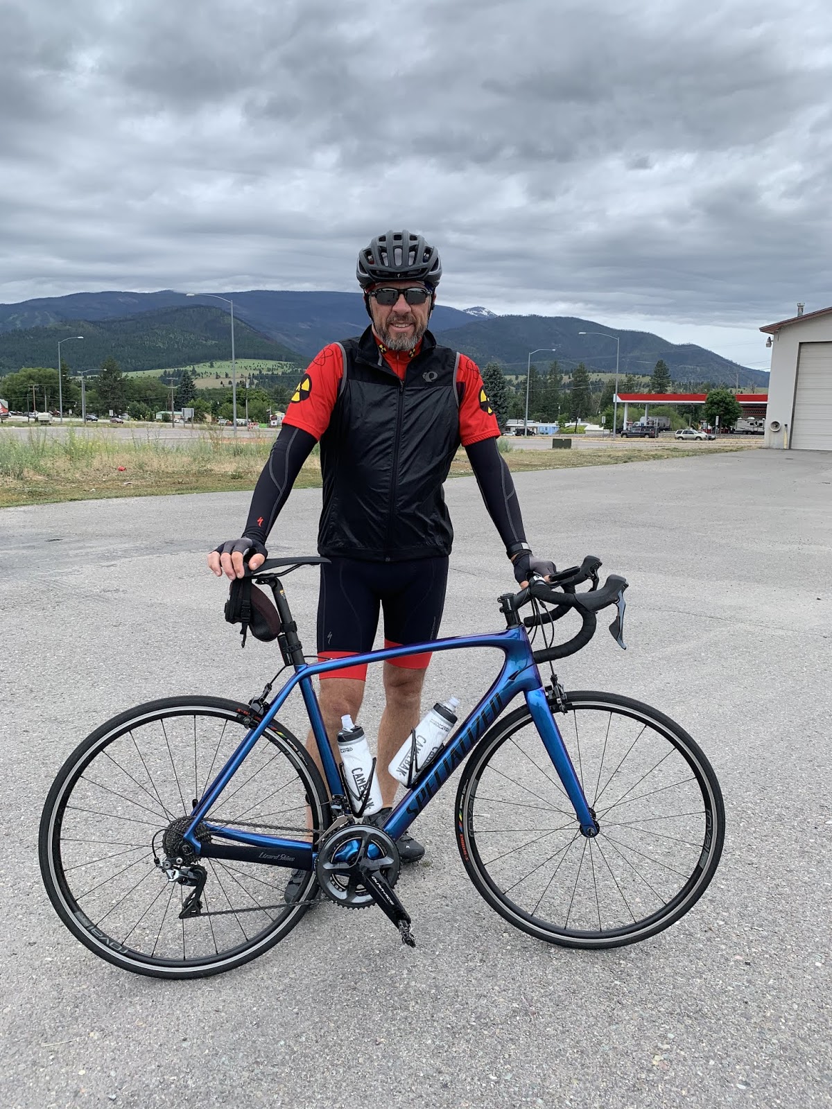
But there were some really scenic spots as well.  I chose this one because it looks kinda cool, it shows the grade (this was a 5% section) and because I'm in it.  Apparently Delta is rubbing off on me.


Oh yeah - this was kinda cool.  I was passed by what had to be a Corvette Owners Club on the way up.  Thirteen late model Corvettes that crept by Sig and me as they worked their way up the mountain.  We were working thru a 7% section at the time and I didn't ever bother to try and catch a pic.  Used by permission of Susan Schoen Photography, LLC.


Then it was time for a short break and some chow.  Kelsy and Parker were right about these darn avocados.  They're good on just about anything.


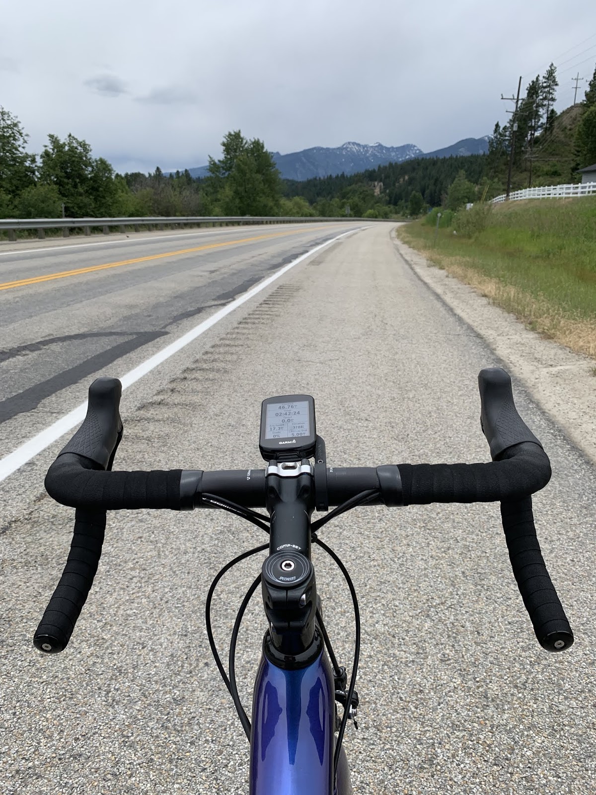
After my Oreo cookie garnished with avocado snack, it was back on the road - where I captured this shot.  Check out the road just above and right of center in the pic.  We just came from down there.  I'd love to get a shot from directly above, but I guess that's what Google Maps is for...


Now we're talkin.  Rest area.  I need me some rest.


But as it turns out, the rest area was for Lost Trail Pass.  We had to turn left on highway 43 and go another mile to get to Chief Joseph Pass.  How does that happen?  Did the guys on the Idaho side not talk to the guys on the Montana side before deciding what mountain they were gonna go up?  OK - what's another mile of 6% grade.  Oh - and ya know you've ridden up hill when you arrive at a SKI AREA!


And while standing in that very same spot, I observed that the Idaho tourism people do actually welcome some people to Idaho, just not me.  Recall the "Idaho State Line" sign I got when I rode out of Hell's Canyon.  Bah!  I've shaken the Idaho dust off of my proverbial sandals and shan't be returning to Idaho.  Chiefly because the route doesn't go there anyway...


Regardless, a mile later we made it to the top.   I think that deserves a thumbs up.  I felt really good for the whole climb and ready to take on the next 45 miles.


Sig, "This is what I came up here for?  This?  Let's go."


I couldn't resist.  A good way to show my softer side.  If you're a lady who likes flowers ya better post on the blog or ya won't see any more of this stuff...  I'm such a softie.


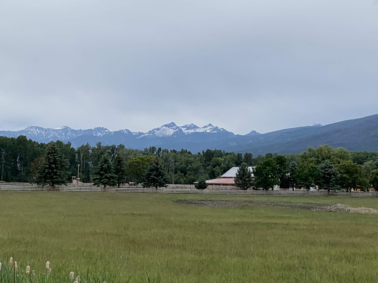
WOW - just...WOW.  I can't believe I took this pic.  And no, its not hanging over the dryers in a RV laundromat somewhere, its the real thing!!!!  After going over the mountain this was pretty much my view for the rest of the day.  Gorgeous.  Good thing, because we had to fight a headwind for the last 45 miles.


Susan was there as always taking care of us.  This is her flagging Sig down at the Big Hole Battleground National Historic site.  Good place for a break.  
As far as Sig is concerned, I'm apparently just along for the ride.


I've heard that Montana is called Big Sky Country.  After seeing this I understand.  Here's my theory.   The Travel and Tourism people came up with this as a way to take a rider's focus off the pavement seams that assault one's posterior with the regularity of a metronome.  Highway 41 was filled with these seams.  For more than 20 miles.  Big Sky only goes so far - and it doesn't go 20 miles, I can assure you.  But it was a sight to see.


Another one!  Holy cow, the scenery around here is to die for.  Unfortunately the mosquitoes were less interested in the scenery than they were in my anatomy.  There is actually a goodly bit of standing water in those lush green fields.  There were clouds of them around.  On one occasion I pulled up to The Rig to pick up some food and water.  Susan had a sign she held up against the window that said something like, "Mosquitoes are BAD here".  (slap)  No (slap) kidding (slap).  She rolled the driver's side window down long enough to hand me some consumables and water, then roared off down the road.  It's a rough life, I guess, driving the rig...  I wasn't troubled by this problematic behaviour as I was the one getting chewed on by mosquitoes and  needed to move along as well.


And then there was this.  I'd never seen such a sign before.  So when I got there I pulled mine out.  Not much happened.  There was a pick-up truck in the same pullout with either Georgia or Florida tags.  The guy had his cell phone out.  We looked at each other and I moved on.  Hey - when in Rome...


And this was the highlight of our day.  Susan found Sam (in blue) and Paul - both from Seattle - as they were leaving their overnight stop in Sula, MT which happened to be just as I was arriving in Sula from Darby.  Since they're loaded tourers and I'm not, I caught up with them in short order.  We chatted a bit before I went on down the road.  But we saw them again at the Battlefield Historical Site and took the opportunity to invite them over to The Rig for dinner when they got in to Jackson.  They showed up at The Rig at about 6:00 and Susan had made a great dinner for all of us.  They were grateful since for most loaded tourers it's difficult to get something close to a home cooked meal while on the road.  We traded cycling lies for almost 2 hours and then said our goodbyes.  They're not riding the same route I am and their route will diverge from ours after tomorrow.  So - we may run into them in Twin Bridges, MT - but maybe not.  That's the way it goes on the open road...

Till next time...

Friday, June 28, 2019

The Thin Blue Ride - Part 2 Day 19 - Lolo, MT to Darby, MT

Ride Report: 64 Miles, 1,044 Total Miles, 17.3 Avg mph, 1,430 Ft. Climbing, 4,826 Calories.

Not a bad ride report.   Nice distance, good average speed, a little climbing.  (OK - let's be honest, the worst grade I saw was 5% and at that only for maybe a half mile.  Mostly it was around 1% uphill all day.)  But as the reader will note form the pics, it was cloudy, and correspondingly cool, all day.  I tire of cold and long for some warm mornings.  Thus far I've had to start at around 0830 each day in order to give it time to warm up enough that I don't freeze.  When doing a BAK we're up and around at 0500-0530 in order to get out early and beat the heat.  Not so much the case here in Montana (or Idaho) as today's pics will bear out.


Susan took this one for me when she kicked me out of The Rig in Lolo.  This is the same parking lot where I met her yesterday before our side trip into Missoula.  Wouldn't want anyone to accuse me of cheating by using The Rig to "skip" a few miles.  1.  Note the fetching black vest, arm warmers, and matching black riding shorts.  I just LOOK fast. 2. Since the course is mostly flat today, Delta is handling the duties.  This is good because Sig got with me late last night and told me he thought he'd ought to pass on today in order to recover fully from yesterday's "events".  That's fine since tomorrow is Chief Joseph Pass and it'll be a big climbing day for him.


The snow capped mountains in the background lie on the West side of the valley we're riding up today.  There is a corresponding set on the East side that lie a bit further away.  Kudos to the reader who can predict what these mountains will do in relation to the valley floor as we continue up.


I worked fairly hard for the first 25 miles, which resulted in some "wet" gear.  (It was sweaty.)  Seeing as how it was cold outside, I didn't wanna put wet stuff back on, so Susan came to the rescue and pulled the old "dry em with the dash heat vents" trick again.  One snack later and they were dry - back on they went.  Hey - its either that or do laundry 4 times a week.


I'll just say that highway 93 out of Lolo to Darby sucked.  The surface wasn't too bad, even on the shoulder, but the traffic was horrific.  There was just so much of it, and all roaring by at 70 mph.  As a result, the ACA worked with local politicians and established a bike trail that runs all the way from Missoula down to just past Hamilton, MT - some 48 miles away.  We tried the shoulder for a while and moved to the bike path in short order.  I'm not usually a big fan of these bike paths since they tend to get taken over by people walking yappers on those stretchy leashes.  Nothing worse than a yapper wrapped around your cranks because his stretchy leash let him get on one side of the bike path while his fawning owner was on the other.   Unless, of course, its a cranky yapper lover bemoaning the demise of her Fluffy by bike.  Plus, then ya gotta get all that leftover Fluffy out of your front chain ring.  Yuk.  But in this case, the vast majority of the bike path was between the few small cities along its route, making for an absence of yapper lovers and a corresponding absence of yappers.  This was a good thing.


As always, when going up a valley between mountains, there is a river.  In this case the Bitterroot River.   And yes - Bitterroot is spelled that way.


If Delta and I saw one of these today we saw 30.  While its adjacent to the bike path most were not, leading us to conclude that they more likely memorialized people driving vehicles rather than cyclists.  I think if that many cyclists had died along a stretch of highway, I'd have heard about it - especially since it's on the T/A.  I'm not surprised.  I observed a plethora of stupid driving from the relative safety of the bike path.


This is Maria.  We met her in Hamilton where she was selling cherries from Mt. Ranier.  I couldn't buy a bag since I had nowhere to carry them.  She was very curious about what Delta and I were doing.  So I filled her in.  She gave me a good handful of cherries.  I thanked her and we were off.  Having nowhere to carry even a handful of cherries, I stuffed them all in my mouth (sorry Mom) and was spitting pits for a couple of blocks.  They were great!


This is The Rig in Hamilton for the prearranged lunch stop.  Apparently I'm not as fast as I think I am because while she was waiting, Susan elected to open up a fireworks stand to help pay for the trip. 
#whodathunk


We included this pic in order to prove we were in Hamilton.  We're a couple of days early tho.  Susan's nephew Scott, his wife Erin and their FOUR kids (two of which are twins) are moving to Hamilton, MT later this summer.  They are arriving on Monday to look for housing, etc.  Too bad - we were hoping to get a chance to see them on the trip.  So - Scott & Erin - we can see why you like the views around here...


One of the views around here...


And another one.  Delta likes this one better because because it has a road in it - and him.


This shot was taken from the same spot as the previous one. I just zoomed the camera a bit.  We were basically looking at this as we rode South all day.  It inspires both awe and dread.  Awe owing to the beauty of the geography of the region, dread because we have to drag ourselves over those cursed things tomorrow.


Ya see a lot of this around here.  This guy is watering a field of... grass.  That stuff must be 3-4 feet tall.  Somebody needs to tell him that the more he waters, the more he has to mow.  And I hope he's not planning on bagging that!

So - that's it from Darby (population 733) for the night.  God bless em for having internet access.  The next few days will take us to Jackson (38), Twin Bridges (381) and Cameron (262).  I don't think there is a snowball's chance in Hell that our luck will hold.  Its kinda like road construction - be prepared for delays.

Till next time... 

The Thin Blue Ride - Part 2 - Reader Alert

As I sit here eating my Reeces Pieces Puffs for breakfast (an entirely separate lecture from my children, let me assure you) it occurred to me that we’re heading to the boonies for a few days and will likely be entirely without cell service.  Result, once again, is no posts till we return from the beyond.

This is a pic of our spot in the Wally-World parking lot last night...

Our little corner of the world - and free for the night.  Tryin to find The Rig in all those RV’s was a task.  I accidentally walked into the wrong one last nite when I walked back from throwing away the trash.  There was a lady in there.  No, not Susan - a different one.  She was all upset...

I left forthwith...

Till next time - whenever that might be...

Thursday, June 27, 2019

The Thin Blue Ride - Part 2 Day 18 - Lolo Hot Springs, MT to Lolo, MT (W/ bonus side trip to Missoula, MT)

Ride Report: 25 Miles, 980 Total Miles, 21.5 Avg mph, 0 Ft. Climbing (Yes - you read that right!), 2,045 Calories.  The reader should note today's average speed: 21.5 mph, BABY!  The reader may also note the big fat ZERO in the climbing category.

This is the first time in three weeks that we've had a flat course to ride.   I was on the Sequoia since it looked like rain when we left Lolo Hot Springs.  The road was dry, so we were optimistic.  But it was  literally no more than a half mile later and the road was wet.  Approximately 200 yards later, my keester was wet. (Sigh).  Oh  - and it was also just barely 50 degrees when we left.  We got rained on for most of the ride.  When a rider is faced with both cold and wet, there is only one answer. (QUIT? No - C'mon...) Ride hard enough to stay warm - so that's what we did.  I ain't gonna lie, it was fun to crank off 25 miles at that pace.  We had actually averaged 22.8 at the 14 mile mark then decided to dial it back a bit for the last 9 miles.  What a blast.  Made me forget (almost) about the wet keester.  But this whole water thing caused problems later...

BTW - no ride pics.  It was largely unremarkable - and wet.  Given the whole cold thing, I wasn't gonna stop for pics unless something jumped up and bit me.  I did see two moose crossing signs.  Fortunately no moose (mooses, meese, moosen?) jumped out to bite me, or I'd have been forced to subdue him and take a pic...

Most of the day was about the bonus side trip to Missoula, that's where all the pics come from today.  Missoula happens to be the home of the Adventure Cycling Association (ACA).  They're the good folks who put out the map that made The Thin Blue Ride a reality.  So, when one is on the T/A (or one of the other 3-4 routes that come thru Missoula) a side trip to headquarters is a necessity.  Hey - when you're on a once in a lifetime hajj, you go to Mecca, right?  So, let's see Missoula...


This is Susan and me and standing just outside.


And the anticipation builds.  On the way in, they had this sign.  I think this is the right place.


This relic, readers, is one of the original signs marking the T/A.  They were placed after the first organized T/A ride in honor of the nation's bicentennial in 1976.  I happen to have one of these sacred relics myself hanging on the wall of our garage in Manhattan.  Found it in an antique shop in Abilene, KS.  To a T/A rider, it's like possessing a sliver of the cross...


(Takes big breath.)  OK - in we go.  Note the bicycle handlebars as door pulls.  Wrapped in handlebar tape, no less.  Very original.


Once inside we met this guy.  His name is Jim McTighe.  He's in charge of advertising, web content and marketing collateral.  Basically, he's their Art Director for the ACA.  Since I'm a member, he gave us a guided tour of Mecca.


And this...this is the Black Rock of the ACA.  This tandem was used by Jim Richardson and Linda Thorpe in 1974 to do route research for what eventually became the T/A in 1976.  It has five gears in the back - and they're road gears.  Not really set up for climbing - and tandems are absolute slugs on climbs.  I can't imagine doing the T/A on this bike.  In the interests of full disclosure and to inform the reader, Susan and I ride a tandem together.


Things have grown exponentially since 1976.  This map of the US shows every ACA route in the country.  They're designated by the thick red lines.  If you enlarge the pic you will see the red circle just to the West of Austin, TX.  That's the Texas Hill Country Loop that was the basis for the Texas Test Flight series of posts I did a few months ago. 


Oh yes - the water issue.  The Sequoia had increasingly been experiencing a creaking sound from his (he was embarrassed by this so keep it on the down low) bottom bracket.  I know, I know.  These things happen as one ages.  But he was worrying endlessly about it.  He was afraid it might affect his ability to perform on the road.  Anyway, I assured him that we'd get him to the Doc when we made it to a town with a specialist.  No generalists for my buddy, mind you.  So, once we hit Missoula - in we went.  The doctors (mechanics) there were very understanding and said they'd take a look.  Both Sig (Susan's name for him, BTW) and I were afraid he might need a bottom bracket transplant.  They took him to the rear and told me to go get my mind off it while they examined him and, "...did what was necessary."  I left with a sense of foreboding.  Sig looked sick about it as I left.


So, taking the Doctor's advice, I went to help Susan with the laundry.  This is what that looked like.  The wet ride this morning had resulted in an inordinate amount of (surprise) wet riding apparel.  Later that afternoon, I got the call.  Sig was OK and I could come pick him up.  He wasn't allowed to ride on his own owing to the "procedure" and all...


So, here he is out and about again with me along to keep an eye on him.  He was moving a little slowly.  Turns out he didn't need a bottom bracket transplant.  Somehow (???) he had managed to get a bunch of water in there and it was causing this ungodly creaking whenever I would really hit the cranks.  The Doc said, "We just had to clean him out and re-grease him.  He's fine now."  Sig was greatly relieved, but still hugely embarrassed by the entire affair and swears he'll never get water in his bottom bracket again.  I was just happy to have him back healthy.


And finally there was this.  As we were walking to the laundromat, we ran across a well cared for house, in the middle of town with - chickens.  This is how one knows one has returned to civilization.  Chickens where they are unnecessary.  Well, that and decent cell phone service.  Did I mention that Missoula is a University town?  Now, off to another marker of a civilized society: Wal-Mart.

Back on the road tomorrow.  First crossing of the continental divide the following day.  More on this as it develops.

Till next time.


The Thin Blue Ride - Part 2 Day 17 - Wilderness Gateway Campground, ID to Lolo Hot Springs, MT

Ride Report:  60 Miles, 955 Total Miles, 13.5 Avg mph, 3,284 Ft. Climbing, 4,155 Calories.  Minus an additional 1.5 pounds this morning.  I'm gonna feel like I'm starving when I have to cut back after this ride...

Big day today – and to illustrate I’ve included a pic of the elevation chart from the ACA map for today’s ride.  I’ve mentioned before that the ACA maps break The Thin Blue Ride (also known as the Trans-Am) into 12 segments.  On each segment, the map provides additional detail in the form of about a dozen 30ish mile sections for a total of roughly 360 miles per segment.  The sections are numbered sequentially starting in Astoria.  So, when the reader looks at this elevation chart, it roughly depicts the elevation gain over sections 32 and 33 of segment 3.  Got it?  If not call with any questions and leave a message.  We can talk when I get back to Manhattan in October and finally have decent cell service again.

We overnighted just to the left of the farthest left red line – we were just barely inside section 31.  The goal for the day was Lolo Hot Springs, to the right edge of section 33.  That’s a total of 60 miles.  As the reader can clearly see, the day was all uphill until Lolo Pass, with the exception of a couple minor descents.  Let me assure you, they weren’t significant enough to relieve the tedium of 52 miles uphill.  That’s how far it was to Lolo Pass, which at 5,235 feet is (I believe) the highest pass we’ve been over since McKenzie.  That, ladies and gentlemen, constitutes a big day.

I have to insert here the gist of a conversation Susan and I had with Kelsy and Parker a couple of days ago.  During the course of this conversation, I received a dissertation on the merits of eating healthy and how the food I was consuming was all “bad” sugar (somebody show me the good stuff then) and how I should consume better quality calories.  This in furtherance of avoiding that "tingly" sensation I described in my legs during the conversation.  Thanks – this set your mother out to buy better food for me.  As a result, I consumed this on one of my breaks…
Yup – an avocado  - and I’m eatin it right out of its shell – or whatever that hard part on the outside is called.  An exoskeleton maybe?  I dunno.  Poor thing.  I must admit that it wasn’t too bad.  And as an added bonus, it made  Kelsy’s mother happy.

But then I got a call from one of The Thin Blue Ride’s corporate sponsors.  They reminded me of my contract and as a result, I was compelled not only to consume their product, but to give it equal billing. Hence…
I demolished a Hostess cupcake - two bites, BTW.  It was horrible. Over the last week I barely managed to choke down the contractually obligated 12 pack.  But duty being what it is, I soldiered on. The fine print requires both resupply and additional consumption.  My God – the horror of it all…

But on with the actual ride – brought to you by Hostess cupcakes - freshness in every bite!

This was the view of the river from the bridge to the RV Park first thing in the morning.  Only 52 miles to the summit...  


This is the Sequoia checking out the next ten mile uphill stretch.  The first 40 miles went like this: ten miles at a crack, then stop for a ten minute break.  I planned today’s ride this way because I knew it was somewhere around 46 miles when the grade would kick up.  I also made it a point to ride easy for the first 46 miles in order to save energy for the real climb between 46 and 52 miles.  There was just a whole lotta this – 46 miles worth, to be precise.


Well, this is encouraging...


As was this just a bit later.  I don't think so...


But this was good.  One of the stops Susan selected for a ten mile break was at what the maps call "pack bridges".  We eventually concluded that they're for the crossing the river on the numerous hiking trails throughout these mountains.  Susan noted that when I went out on the bridge with her it swayed.  It was a suspension bridge for God's sake.  How is that my fault???


On the way up, I ran into this historical marker.  Is there any place those Lewis and Clark guys DIDN’T go in these parts.  How did they not end up with a state or two named after ‘em?  I propose re-naming Washington and Oregon as Lewis and Clark respectively.  I had a sense that the end was near when I saw it.  And sure enough, about 2 miles later…


State number three – Montana!  I don’t know if the reader is aware (I certainly wasn’t until today) but Lolo Pass demarks the state line between Idaho and Montana.  Cyclists tend to affix stickers to such signs as a memento of their passing.  Hey - its the T/A.  A lotta riders have been thru here.  Not me tho – I’m not in to defacing public property.  That’s my story and I’m sticking to it.


However, there being no Lolo Pass sign, I took a pic of the next best thing.  I believe this is a snow depth marker.  Holy Cow! That’s some snow.


So, this is me pointing out the benefit of spending all that time going 52 miles uphill.  The reward?  Eight miles of downhill.  Seems disproportionate, I know, but such is a rider’s life.


This is home for the night – Lolo Hot Springs.  We reserved a spot for The Rig in the RV Park just across the highway from the Hot Springs.  As I pulled in, Susan had just finished checking in and was pulling in to our slot.  I kept up with her for the first 4 miles of the downhill, but then it leveled out a bit and she was able to get ahead of me.


This is one of the benefits of overnighting at Lolo Hot Springs.  It’s kinda implied in the name, but they have a hot springs here and use it to feed both a swimming pool and this (much) warmer and smaller pool.  This baby was right at 103 degrees at the “cool” end.  That would be the end farthest from where the spring water enters directly from between the rocks.  I did two stints in it.  Stayed a bit too long the first time and my legs were wobbly when I got out so I had to sit down on the conveniently placed benches. (Oh, that’s why they’re here.)  The reader should note a couple of things in this pic.  1: The nifty biker tan I have going.  2: The absence of said tan on my right shoulder.  (Yes reader – your left)  The white spot there is a scar left over from sliding down the road after tangling with the mini-van while on a lunch hour ride last September.  I still watch mini vans closely when encountered on a ride.  Them and logging trucks.  The mini vans are the chihuahua of vehicles.  It’s always the little ones that that have the worst attitudes.

Now I want to take a moment to follow up on something I mentioned yesterday: Brad Schoen’s Mountain Misery Index.  We’ll just use the acronym BS-MMI. It goes like this.  In order to determine the index one must first calculate the Fatty Factor (FF).  FF is simply the rider's weight divided by the number of bottles of water consumed during the climb.  A rider can positively influence the FF by either losing weight or increasing water consumption during a climb.

Next one must Determine the LAG (Length and Grade).  LAG is a measure of the length of the climb to the nearest tenth of a mile multiplied by the average grade (expressed as a percentage) of that same climb.

The FF is then divided by the LAG in order to determine the BS-MMI.  The lower the quotient the more difficult the climb. 

Expressed mathematically the formula looks like this:

Rider weight / Bottles Consumed = FF
(LG) X (%G) = LAG (Length and Grade)

 FF
LAG = BS-MMI

So - now a real world example.

203 (my weight) / 6.2 bottles consumed
8.2 (length of climb) X .05 (5% grade)

32.7
.41

BS-MMI = 79.8.  That's a pretty tough mountain, owing - in this case - to the length of grade.  Ya can't make this stuff up.  And, I might add, it serves as further proof of the scientific basis for my many and varied speculations.

And my high school math teacher thought I wasn’t paying attention.  Bah!

And if the reader will permit, one last pic for today...
This is what Susan’s plan for today looked like.  Yup - she did it - solved the whole quantum mechanics thing.  Right there on the dash of The Rig.  It was the uncertainty principle that gave her the hardest time just before breakfast.   Actually, it’s her way to track when and where to stop and wait for me to pass by.  She just enters a parallel universe and waits for me to pass by in my universe, then reappears.  According to her, it was much easier than figuring out teleportation.  She didn’t have to figure out how to disassemble and reassemble all those molecules.  I was pleased since I like my molecules just fine the way they are, thank you.

Till next time.