INTRODUCTION

Where to begin? It was a dark and stormy night...  (Snoopy).  No. It was the best of times, it was the worst of times...  ...

Friday, July 19, 2019

The Thin Blue Ride - Part 2 Day 40 - Breckenridge, CO to Fairplay, CO

Friday, July 19th, 2019

Ride Report: 31 Miles, 1,973 Total Miles, 15.4 Avg. mph, 1,972 Ft. Climbing, 2,453 Calories, 1 Hoosier Pass, 3 Happy Campers, 1 Wrecked Camper.

Breaking News>>>>New maximum speed for the trip = 48.9 mph.

Breaking News 2>>>New maximum average speed to complete a major climb = 9.1 mph.  We reached the top of Hoosier pass in 1:10.  Don’t get me wrong - there are likely plenty of people who have done it faster, but those numbers exceeded my expectations.  And not one of the three of us felt taxed by the effort.

The breaking news stories no doubt contribute substantially to the 3 happy campers mentioned in the ride report.  As for the 1 wrecked camper, the reader will just have to...well...read...the rest of the post.

The original plan for today was just to climb Hoosier Pass and then return to Frisco.  This because the two days following (to get to Pueblo) were both rather long riding days.  We figured that anything we could do to make those two days easier would be a good thing.  So: 1 Climb Hoosier Pass.  2 Shorten the following two days by 10 miles - that's the distance to the top of the Pass.


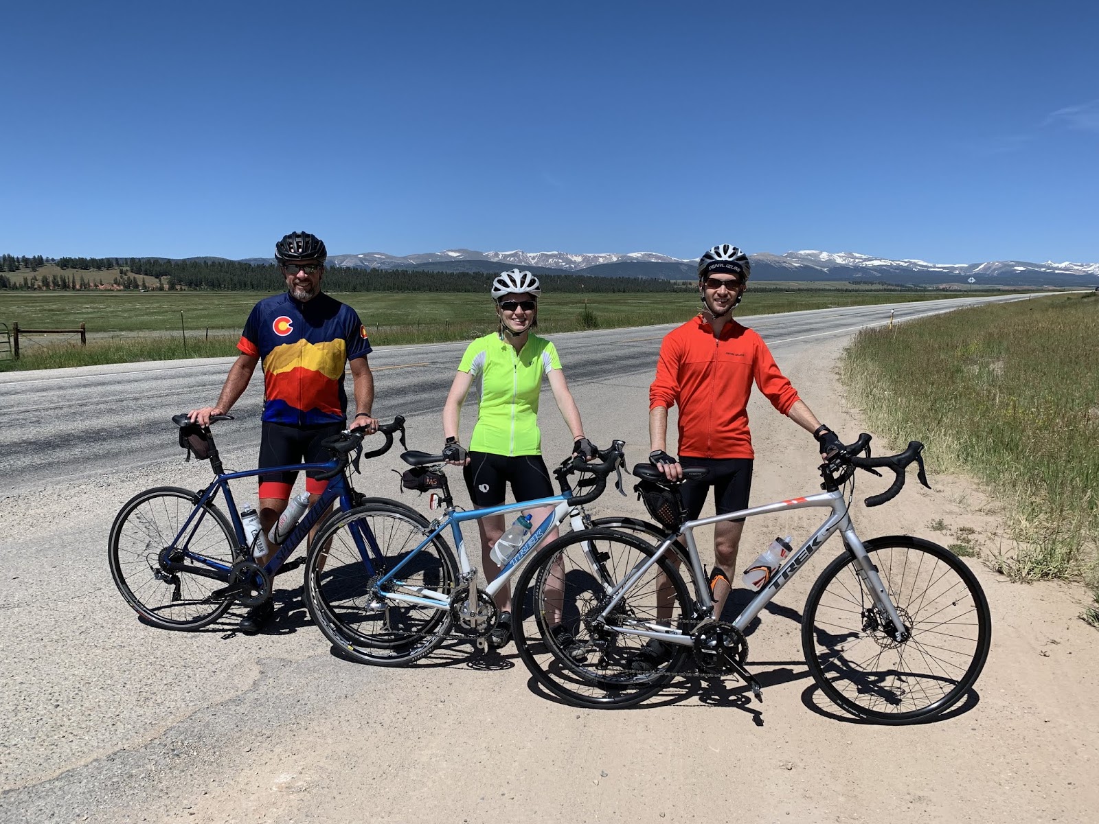
These are the three happy campers mentioned previously.  At the start of the day.  That's why we're all happy, and a bit anxious.  Ya don't hear stories about the highest point on the T/A and not get a bit anxious - no matter how many passes one has been over since the start of the trip.  And keep in mind, this is KnP's first big mountain pass.  We'll see how it goes.


Susan did what, at this point, has become our custom for dealing with mountain passes.  Drive a short distance ahead, find a pull-out and wait for riders to arrive - then see if they need anything.  We were 5.4 miles into the climb before we stopped for any length of time.


Just over half way up and still smiling.


Just over half way up and again...still smiling.  This is a good sign.  At this point I might mention the biggest disadvantage in any climb worth the name.  Weight.  Look at these two - just look at 'em.  Look at me in the previous pic - or in any pic taken of me after I reached the age of 28.  My guess is that between the two of 'em they total about 235.  I weighed in at 203 last time I checked. No wonder they're smiling.  I may be smiling on the outside - but I'm grumpy on the inside.


Yes - Delta was smiling as well.  Not normally known as the climber of the two, he did so well getting to Breckenridge that I decided to give him a shot today.  We both thought things went swimmingly.


Once again, the views fail to disappoint.  But I might also point out to the reader the road running across the bottom third of the pic.  This pic was taken after one of the 7 hairpin turns in the last few miles of the climb to Hoosier Pass.  At the time I didn't think much of it, but when we came back down, I was surprised at the elevation gain over such a short distance.


This is me, Kelsy and Parker approaching the summit.  Susan was kind enough to walk partway down in order to snap a shot of us nearing the top.  The reader should note that the only one of the three of us grimacing is in the lead.  Parker would occasionally sing along with the tunes he was listening to as he rode.  Weight...  (Used with permission of Susan Schoen Photography, LLC.)


After we blazed by at about 8 mph, Susan took this shot.  The reader should not speculate as to the reason for my grimacing.  Yes, I may have been working a bit harder at the moment.  When I see The Rig, I'm like a horse getting back to the barn - pick up the tempo.  There's a reclining love seat in there with my name allllll over it.


This is us with the obligatory pic at the summit.  Kinda a big deal.  And the last alpine pass of the T/A.


Sometimes ya just do what ya gotta do to celebrate.


And then there was this guy.  His name is Matt.  When we were taking pics, he stopped to chat us up.  Turns out that he lives on highway 9 just below the hairpin turns near the top of the pass.  He's mostly retired now and was out for a sunny 110 mile jaunt over three mountain passes before getting back home.


I wanted to get in on a pic with Susan at the top.  Without her support I'd not have made it this far.  This is true of today as well as The Thin Blue Ride in general.


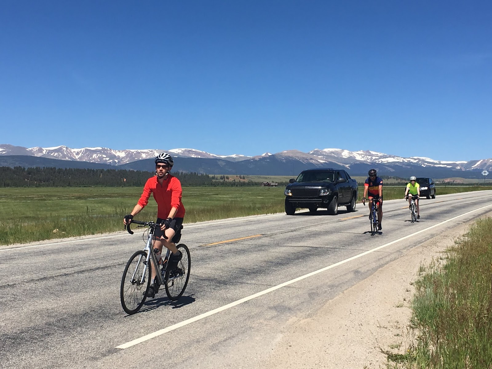
This is the back side of the pass coming down into Fairplay, CO.  At one point highway 9 went thru a couple of mild corners and then opened up for maybe 1.5 miles of straight downhill at 6-7%.  This is where weight is a plus - and also where the new course record was set at 48.9 mph.  We Clydesdales move rather fast downhill.  The greyhounds, however, are left in our wake.  Just sayin...


An action shot taken on the road South of Fairplay.  Everyone was feeling so good at the summit that we decided to ride 9 miles past Fairplay before returning to Frisco for our last night at the Heaton Bay Campground. At this point we had a 1-2% downhill and a moderate tailwind.  Net result - we cruised along at between 25-28 mph for most of those 9 miles.


This is Shaun from Seattle.  He's riding the T/A East to West with a couple of detours to see places he lived growing up.  These places included Taos, NM and Georgetown, CO.  Thus making his cross country trip about 5,400 miles.  On this day he was planning to stop in Fairplay.  When we got there on the way back to Frisco, he was at the gas station where we filled The Rig with gas.  We accosted him and forced him to take an ice cream sandwich.


The scene South of Fairplay.  Parker proclaimed that he wanted to live in this valley.  I can't say that I disagree - at least on a philosophical level.


And this is where the easy cruise South of Fairplay ended.  Susan picked us up at a good spot to turn The Rig around.  Total trip distance for today was 31 miles - thus considerably shortening the remaining two days to Pueblo.  We'll return to this point to start the day tomorrow. 


And...still smiling.  21 miles of downhill will do that to ya.  BTW - I will be sorely disappointed if every single one of you hasn't already noticed that I'm wearing my new Colorado jersey.  I'd been looking for one for some time and found one that fit yesterday.

Oh yes - and lest I leave the reader hanging...

...this is the wrecked camper.  The right side is submerged in the river up to the roof and a portion of the over-cab sleeper has detached.  We don't know what happened, but...


...if the reader enlarges this pic and looks closely at the dirt just to the right of the post on the left, the reader will note that the soil has been very recently disturbed.  Disturbed by something like, oh... an RV tire.   Amazingly, it appears that it was just driven into the river.  That's my conclusion anyway.  This one almost beats the pic of the logging truck that tipped over in Oregon and scattered logs like pick up sticks.  But only because, "There but for the grace of God go I."  And to be perfectly clear, this is not The Rig.

And let me close with this.  Life (and climbing mountain passes) is all about managing expectations.  If one lowers them sufficiently, one can never be disappointed.  We all went into the day expecting the pass to be miserable.  When it wasn't, we were all pleased.  So there ya have it, my recipe for a successful and happy life - go in with low expectations.

Till next time.


Thursday, July 18, 2019

The Thin Blue Ride - Part 2 Day 39 - Breckenridge, CO (Rest Day)

Thursday, July 18th, 2019

Ride Report: None (Planned Rest Day)  And I shall entertain no complaints from the peanut gallery, having ridden for 8 straight days to get here.  So, all you peanuts out there read on at your own risk.  On to other matters.

Kelsy and Parker (KnP) showed up yesterday evening at about 1845 (That's 6:45 PM National Guard Time - ask somebody on active duty) having arrived from Palmer Lake, CO.  It was about a 3 hour drive, they took the scenic route and avoided I-70.

And in a bit of an unusual move, I've elected to take the day of from blogging.  Calm down, calm down.  That was the bad news.  The good news is that I've located a ghost writer to handle today's duties for me.  From this point forward, I'm blameless...

I'm a big proponent of food.  Thus I recommended we find a local breakfast place to start our day off right.  Never mind the detour that delayed our breakfast.  We stopped by a local bike shop to get Delta's derailleur tuned up.  Having just meet Delta I can't make any judgments yet, however, he seemed happy to go in for a spa day.

Here we are at Bread + Salt.  Dad got pancakes with real maple syrup.  I was able to snag a sample and it was delish.  

Next on the agenda was getting the week's laundry done.  Mom put my usual laundry practices to shame.  We had several strategically sorted loads all with different temperatures.  I heard a scoff at the inability to adjust the intensity of the clean provided.  No gentle cycles here!  I refrained from telling her I have a pants and shirts load... all washed on cold.  :|  Once our four individual loads were started we went for a stroll around downtown Frisco, CO.  

Here's Dad looking.... touristy?  He claims this is his tourist face and asks the reader to enlarge the picture to view his "scrunched up nose," somehow this is imperative to the tourist motif.   
  
Following the laundry we were back to The Rig for a "break."  Breaks seem to be required 2-3 times per day here on The Thin Blue Ride.  Parker and I have no complaints regarding these breaks.  It feels nice to spend time away from the work grind doing nothing and enjoying each other's company.

Here is Dad taking nap number 1.  Nap number 2 was prevented by typical rest day chores, there was grumbling but no foul language was heard.

After a break from chores we headed off to Copper Mountain to try out the Alpine Coaster.

Here we are at the base of Copper Mountain, ready for adventure.

Come to find out that Copper Mountain is home to the longest Alpine Coaster in North America at 5800 feet with 10% grades.   Most of my father's avid readers will be used to % grades being used to define the agony of a mountain climb.  However, this 10% was pure fun!  We roared down the mountain, it was a blast.  Little to no breaks were used by all.  Below we'll start with everyone's mug shot prior to the ride:

Here I am, ready to ride!


Here's my handsome husband looking cool at first glance - backwards hat, Ray-Bans, right out of a B.O.B. song.  For the older readers in the crowd feel free to look that up for a shot of pop culture.  I will say the ticket clutched in his hand takes the cool factor down by 2.


Here's Dad on his way up.  Having listened to the aforementioned song he is now a backward hat kind of guy - got to fit in with the hype.  ;)


Yes even Sasquatch was spotted today.  However, now knowing the origins of the legend he seems to be pretty fair from home...

For those in the Cary Clan who will all be wondering (and will likely not be surprised) - Mom did not ride the Alpine Coaster.  There was mild prodding and convincing tried by the rest of us.  However, we all agreed given her prior "luck" with family adventures it was better she sit this one out. (See: nearly drowning on a rafting trip, riding a bike into a 6 foot hole while mountain biking, etc.) 

Following the Alpine Coaster we headed over to Breck (that's Breckenridge for those not privy to Colorado lingo) to "stroll" around main street.  It's very important that all ambulation be referred to as strolling.  Any mention of "hike" or "walk" causes instant low back pain for Dad. *insert eye roll*

Here we all are ready to explore Breck.  

The water is HIGH everywhere here.  Props to Dad for the gorgeous pic.  The flowers are prominent around these Colorado mountain towns and their colors are so vivid mom and I can't get over it.

I may have been the devil's advocate for the pick below.  Mom couldn't believe I was instigating this set up.  What can I say... If you can't beat em, join em.

Here's Dad kissing another statue.  Can't remember the guys name but he found a 11 lb gold nugget and this is the statue in homage of him.  The plaque states rubbing the nugget is good luck.  The rest of us felt comfortable with that type of statue interaction.

Downtown Breck is full of the standard tourist shops, local artist and jewelry shops, lots of t-shirts vendors, and homemade ice cream shops (yes we partook - recall I love food).

We came across this LARGE bear.  It e came across with signs stating you COULD sit on it.

Surprisingly the bear gave Dad a kiss as he approached.

After Dad's back was thoroughly tired from our trek *correction* stroll around Breck we headed back to The Rig.  The evening has consisted of picking up Delta from the spa, organizing ourselves for tomorrow's ride over Hoosier Pass, and eating Mom's delicious sweet and sour chicken.  Dinner was eaten at The Rig's dinning table with view of the mountains.

I'll pass the blog back over to Dad and see if it reaches the standard for his regular readers.  Wish me luck on the mountain pass tomorrow, having never done one I'm not sure how difficult it will be.  Needless to say the downhill will make it all worth it - that's what us riders live for. :P

Till next time.   

(Author's post script: Like I said - blameless.  I may need to explain further the concept of "ghost writer".)


Wednesday, July 17, 2019

The Thin Blue Rider - Part 2 Day 38 - Kremmling, CO to Breckenridge, CO

Wednesday, July 17th, 2019

Ride Report: 45 Miles, 1,903 Total Miles, 14.5 Avg. mph, 2,589 Ft. Climbing, 3,427 Calories and 1 bike path too many.

We decided to go ahead and come into Frisco to stay last night.  When we reserved a spot at Heaton Bay Campground, we had to take 4 nights in order to get the reservation.  Since we were paying for it anyway and it was only about 29 miles to the Campground it seemed the thing to do.  This, of course, meant that before the ride could start today we had to return to yesterday's stopping point at the N end of the Green Mountain Reservoir.  One could either take the long way around the lake (the ACA route for the T/A) on County Road 30 or take the more direct route on Highway 9.  After Susan and I discussed it, I opted for CR 30.  The problem with 9 is that it is very heavily trafficked and the section by the Reservoir had minimal shoulders.  Something about a lot of truck traffic and an 18 inch (at best) shoulder that just doesn't sit will when the option is light traffic.  Even if the option is a mile and a half longer.

And I guess I'll just vent my spleen now before we get to today's pics.  I've mentioned this before.  I hate bike paths.  The first half of the ride today was on roadways - just like always.  But traffic being what it is, the ACA folks put us on the bike path that runs from the North end of Silverthorne where Highway 9 enters the city all the way to Breckenridge.  It was the worst part of today's trip.  Among the laundry list of problems: (1) Some guy throwing a tennis ball in front of me for a (loose) dog to retrieve as I rode past. (2) Three separate occurrences of people sitting on the side of the bike path and then pulling out directly toward me going in the opposite direction and doing so from the wrong side of the path. (3) Children (not their fault - parents were present) crossing the path in front of me. (4)  Kids on skateboards riding on both sides of the path.  (5) Tourists on bikes (not tourers) with no idea of bike etiquette.  Need I go on?  Bah!  The next time the ACA puts me on a bike path I'll just look for the nearest divided highway. - and then drive down the center of the opposing lanes.

But enough of my incessant carping.  I've not even complained about riding uphill all day and fear I may have indulged the reader in enough whining before I even get to that.  So I guess I'll cancel the series I had planned on why I hate 45 mile uphill grades and just get on with the good stuff - and there was plenty today...


Susan took this pic of me as I left The Rig and headed out on County Road 30.  The reader should not be deceived, the slight downhill grade seen here lasted for all of about 30 yards.  I include this pic as a reference point for what comes later.


Within about three miles of today's start I went across the earthen dam that holds back water for the reservoir around which we're riding.  It has a simple spillway to control the level of the reservoir.  When I showed this to Susan she thought it looked like a giant water slide.  I agree - except for the concrete blocks they put at the bottom where the reader can (barely) make out water turbulence just before it goes into the river channel.  It was fun to watch.  But shortly, I had to move along. 


Susan took this pic when she stopped along Highway 9 on "her" side of the lake.  The shoreline the reader can see is "my" side of the lake.  She had a better view of the mountains than I did since I was traversing the hills and draws on my side.  Used by permission of Susan Schoen Photography, LLC.


This is the view from my side about 3/4 mile after leaving the spillway.  By then Delta and I had climbed to the top of a hill with a great view.  If the reader looks closely at the edge of the nearest hill on the left side of the pic, one can make out the road around the base of the hill.  In one spot along this road, the hill had obviously suffered a pretty significant collapse above the roadway and resulting land slide had covered the road and gone into the lake.  Glad I didn't happen to be riding past then!


A little ways further down the road (and up in elevation) Delta and I came across this.  This pic was taken looking back from the direction we came.  Some of those cracks are 2 feet wide.  Interestingly, there was a small stream on the uphill side of this mess which drained into the culvert on the left side of the pic.  The culvert drained toward the bottom of the pic.  After contemplating this and the earlier land slide, I concluded that in both instances, snow melt runoff had saturated the soil to the point that it lost cohesion and slumped.  Not sure how ya go about fixin that.  Maybe just let it stabilize and then throw some more dirt on top of it?  That seems to be the approach to handling pavement seams here in Colorado - and in several other states thru which I've ridden.  Just put some tar on 'em and throw on another layer of chat.  Just sayin...


This is the view from the South end of the lake shortly before CR 30 rejoined highway 9.  I liked this one because of the bluffs and the road along the edge of the reservoir.  The road the reader can make out would be the same on Susan took with The Rig.  It's really a pretty impressive pic if the reader cares to enlarge...


And for the paucity of good pavement early in the trip around the lake, the County got their act together for the last 4-5 miles.  Delta liked this one - it shows off his "Purple Phase" as he calls it.

I didn't take much in the way of pics for a while because all there was to look at was an uphill grade.  So, the next pic you see...


Is me pulling in to meet Susan at the North end of Silverthorne.  Check out that pic.  Mountains, trees, Delta, me.  For several years before The Thin Blue Ride I thought a lot about riding the T/A, the people we would meet, the scenery.  This pic puts me in the scenery.  Used by permission of Susan Schoen Photography, LLC.  (In the interest of full disclosure, when Susan showed me the earlier pic she had taken of me leaving for today's ride, I asked her why she was always taking pictures of my butt.  This may have prompted her to get one of me inbound for a change.)


I suspect a lot of readers will know about Dillon Lake located near Silverthorne/Dillon.  This pic was taken as I crossed Dillon Dam on the bike path mentioned previously.  The reader with an eye for detail will note the sail boat near the top, right edge of the water.  I was somewhat familiar with this path, having ridden it a couple of times when Susan and I were in Summit County for a week several years while I prepared to ride the Copper Triangle.  That particular ride was 85 miles and three mountain passes.  I wasn't in as good of shape then as I am now, but then again, I wasn't as old as I am now either.  They prolly about balance out.


This is a great shot.  The bike path wanders thru this wetland just North of I-70 and just West of Frisco.  As an interesting side note, the campground we're staying at is in the green peninsula the reader can see sticking out into the lake.  A great location.


Lest the reader forget, today's ultimate goal was Breckenridge.  And just like magic (45 miles worth of sweaty magic, but magic none-the-less) here we are.  We've already loaded Delta in The Rig and I've ditched the helmet for this pic.  What the reader sees in the near mountain in the background are the ski runs at Breckenridge.  We're breathing some rarefied air now at 9,600 feet.  Not as rarefied as Hoosier Pass at 11,542, but still pretty rare.  BTW, for the reader who doesn't care to do the math - the difference between the two is 1,942 feet.  When we tackle Hoosier Pass, those 1,942 feet will be gained in 10 miles.  Try it some time - just for fun...

Till next time...


Tuesday, July 16, 2019

The Thin Blue Ride - Part 2 Day 37 - Rand, Co to Kremmling, CO

Tuesday, July 16th, 2019

Ride Report: 64 Miles, 1,858 Total Miles, 16.8 Avg. mph, 2,533 Ft. Climbing, 4,829 Calories.  Today's top speed = 43.7.  The Thin Blue Ride has provided some fun descents lately.  I know I hit 40+ two other times today, but the Garmin only tracks the top speed unless I wanna go digging thru graphs.  Bah - not me.  I've not the patience for it.

Recall that today started with a climb to yet another Continental Divide.  I think this is 7 or 8?  Who knew we had such a divided country?  It was about 5 miles of 5-7%, and it was plenty cool when we started.  I think around 47 degrees.  I know I've said this before, but once the first 5 minutes passes, that's a perfect temperature for climbing.  The problem is with the descents - a bit nippy...

We stayed on Colorado 125 again today, and a more abominable imitation of a highway I've yet to meet.  From the time we got on it three days (?) ago there were pavement cracks every 30 feet.  An NFL down and distance crew couldn't be so regular.  And some of these cracks were 3 inches wide with a drop of two inches.  When ya hit a pavement crack and your helmet slides down over your eyes, you know you've hit a pavement crack.  Good riddance.  We turned off of 125 and onto US 40 just South of Granby, CO.  A much nicer road.  Most of the time with excellent shoulders upon which to ride as the people in four (and more) wheeled vehicles roared past on their way to do...stuff...stuff worth roaring past for.  I dunno.  This retirement thing has made me forgetful.

So here's the day in a nutshell...

The Continental Divide - I somehow managed to snag some excellent company for this pic.  She was there waiting.  What are the odds?


Again - excellent company.  Delta doesn't see too many Continental Divides, but this one wasn't especially strenuous.  And it was his turn.   Note the arm warmers, vest and tights.  (I can't believe I just said tights, much less that I'm publishing a pic of me wearing them.  Henceforth they shall be referred to as "riding pants that keep my legs warm".)


This was a cool rock outcropping that we ran across at another rest stop, where there was also a little bridge over...


...a creek.  Forty years and we still gotta learn those shadows how to behave in public.  Next thing ya know there will be gaggle of little shadows running around.  And no - I don't have a big head.  I'm wearing my helmet.


Starting to see some interesting rock outcroppings along the river we're following to Kremmling.  It's been a while.  Delta was tempted to go plant some sage brush on the side of that rock. 


It warmed considerable after we hit US 40 - note that all the outerwear has disappeared.  This narrow "valley" was entirely covered with grass - and was entirely filled with standing water - which was entirely filled with mosquitoes.  These things are a plague the likes of which hasn't been since wince hand carts worked the streets of Europe picking up corpses.


And there was also Byers Canyon.  It was narrow, had a high rock wall on the right along with a railroad track, tree covered slopes on the left, the Colorado River ran down the center, and it was all downhill.  Downhill enough that we only got passed by one car on the way down.  It also had enough turns to make it interesting, but not so many as to detract from the view.  And it went on for five miles.  We're still on US 40 South of Granby in case the reader is ever out this way.  It's worth a look.


I couldn't help myself - this another shot of me in Byers Canyon.  Once again the T/A route planners got it right.  Just amazing views.  Do those glasses make my nose look big?  I don't know that Susan would tell me if she thought so...


We stopped for lunch in the parking lot of the Parshall Inn.  Parshall is a pretty small town, but if you Google Map it, it shows up.  Good thing I have Willie on my contacts list.  I'm not sure he knows.  I'll have to text him and fill him in.  I hope he's not drunk again when he texts me back.  His messages are so scrambled as to make them incomprehensible at three in the morning.  I've been to Luckenbach Texas (See the Texas Test Flight) and just don't see what he gets out of the place.


Lots of uphill today.  This will be the case until we reach the top of Hoosier Pass.  


Speaking of which, now we're at least in the same County as Hoosier Pass.  I've gotta say, we spent a lot of time in Summit County as a family when the kids were little - mostly skiing every winter.  I've never seen the North part of the County before.  My assessment - it's quite striking and well worth the reader's time to make a trip out this way in the summer.

OK - so tomorrow gets us to Breckenridge in about 45 miles.  We hope to make it there in plenty of time to set up camp, clean the "house" up a bit (Got comp'ny comin' doncha know.), that sorta stuff.  We'll have to see if an early arrival comes to pass or not.  The winds aren't supposed to be particularly favorable tomorrow.  As a result, the reader should be prepared for a good bit of whining by...someone.

Till next time.