INTRODUCTION

Where to begin? It was a dark and stormy night...  (Snoopy).  No. It was the best of times, it was the worst of times...  ...

Saturday, September 28, 2019

The Thin Blue Ride - Part 3 Day 20 - Grand Isle, VT

Saturday, September 28, 2019

Drive Report: 0 Miles / 0:00 - Unless ya count the ferry ride...

Just So Ya Know Report:  I checked the rudimentary stats provided by blogger.com today.  Can't do a lot of analysis, it's not very sophisticated.  But I can report that I had readers from Russia, Ukraine and France in the last week.  The reader should know that this officially makes The Thin Blue Ride (and by extension yours truly) kinda a big deal.  I guess the other reason to read it is to find out what the Accounting Department/Teamster/Team Manager/Smuggler has been up to lately.  Now excuse me while I go buy her some bigger hats.

It rained for most of the morning, but that was fine because we read late last night and slept until (I hesitate to admit this) 1100 this morning.  I think the last time I slept that late was shortly after we married - we were living in either our first apartment or the mobile home we bought when I got out of the Army and went to K-State.  It’s been a loooooooong time.  Anyway - we didn’t lose much since, as I said earlier it was raining  - that sorta curtails any outside adventures with the scooter as our ride.

This is not to say that we didn’t get out.  There was supposed to be a break in the rain between about 1100 and 1600.  Since that information came from “AccuWeather” I looked at the radar myself and confirmed that there was a break in the rain which should last for several hours, so off we went.  Sometimes the day’s excitement is a curvy road to Smuggler’s Notch, sometimes it’s I-87 to the nearest Wal-Mart.  Today was the later since we were running out of milk.  Which is, admittedly, my fault.  Susan drinks milk like a kid drinks medicine.  I, on the other hand, consider it the nectar of life - right behind Diet Pepsi.  And since DP doesn’t do much for Reese’s Pieces cereal (don’t ask me how I know this) we made a milk run to Wally World.

The fun part was that we got to take a ferry to do it...

As we waited for the ferry to unload I noticed this - an ambulance.  I'm not sure how that works.  (911 phone rings)  Ambulance guy:  Can we help you?  Screaming wife:  My husband is having a heart attack, please come!  Ambulance guy: Sure thing ma'am - just let me check the ferry schedule, then we'll be there right after it docks and we debark.


(Since the Research Department checked on this earlier, I want to make sure I use the right terminology.)  This is the scooter on the ferry, right after we barked.  We're headed across Lake Champlain to Wally World.  This ride lasts about 15 minutes.


Which is plenty of time to go up to the poop deck hamming it up for the camera.  Stop rolling your eyes and Google it if you must.  Note the couple at the bow of the ship with the stroller.  I hope they have the brakes locked on that thing...


You know what the definition of a ferry race is?  That's right - two ferries.  We got ourselves a race.  Well - actually, they run three ferries at this time of day.  One is debarking, one is barking and one is in transit at any given moment.  We caught a pic of this one just as we left the dock.  (Side bar:  The California Research Department is headed up by a long time friend - Chuck Putnam.  I want to be sure to give credit for the terminology where credit is due.)


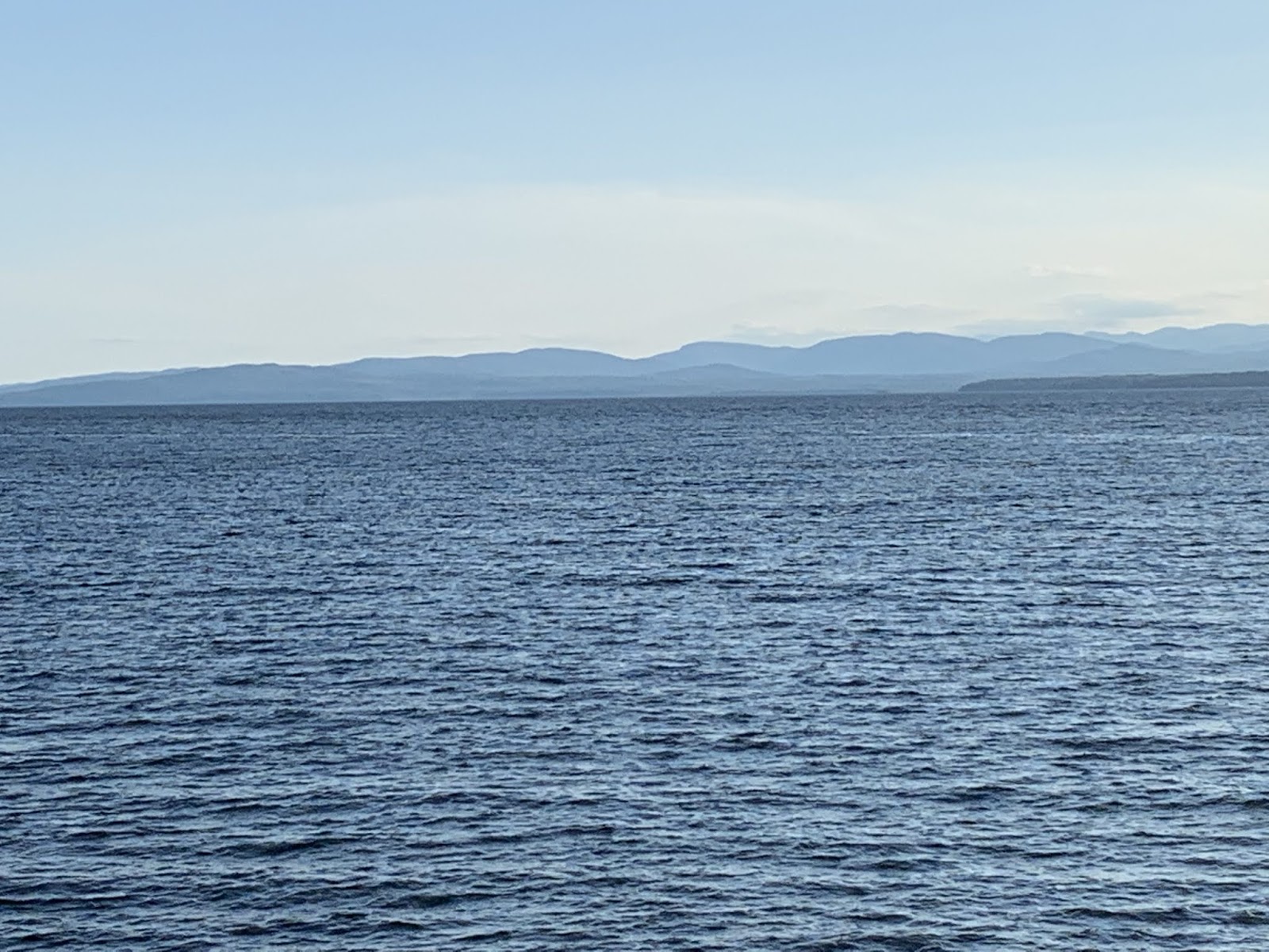
We also caught a glimpse of several sail boats plying the waters of Lake Champlain.  This one happened to have its sails furled.  I gotta say, sailing on a lake this large with those mountains as a backdrop - that'd be a blast.


The scoot wanted a selfie with a ferry.

The scoot's vanity aside, we now move on to weightier matters.  In that vein, I ask that the reader next consider the two pics below and then vote for the best Sea Captain pose...

The first pic is Susan standing at the bow of the ferry gazing off into the distance as she imagines Captaining the Mayflower in search of the New World and Plymouth Colony.  Note the windswept appearance, the storm clouds and the purple slicker.  These add to the ambiance of the pose.

The second pic is me auditioning for the lead in the remake of Master and Commander.  The reader should ignore the fact that I'm standing on the shore, the weather is bright and sunny, I have no slicker and am wearing cargo shorts and Merrills.

Let the voting commence...

And as we pulled in to the dock on the return trip, I thought the reader might like a quick look at where The Rig is parked...  

OK - that's not The Rig - the danged ferry got in the way.  It's about the same size as The Rig, but The Rig is parked on shore, to the left of the yellow house peeking out from behind the trees and is just hidden by the trees above the bow of the ferry.


With no ferry in the way we're just behind the trees to the right of the rock jetty protruding into the lake in front of the gap in the trees.  And the campground is pretty empty.  Most of the seasonal campers have left and there are very few of us short-termers.  As of today, I don't know where the nearest occupied camper is.

Oh - I got the first pangs of, "I'm ready to head home" today as we were walking thru Wal-Mart.  Understandable, I suppose, since we left on May 22nd.  The timing is probably about right.  First, it was just a momentary sensation.  Second, we're due to pull up stakes here at Lake Champlain on Monday morning - less than two days hence.  I sense that I'll spend some time in the future reflecting on the trip and that I may then be better able to better describe it's impact.  But for now, let me just say that I think it was a great way to start retirement.  And finally, since the rest of the day will be spent planning the various legs of the return trip and doing some reading, I'm gonna go ahead and post early today.

Till next time.

Friday, September 27, 2019

The Thin BlueRide - Part 3 Day 19 - Grand Isle, VT

Friday, September 27th, 2019

Drive Report: None - we went exploring today, but on the scooter instead of in The Rig.

Tis a wee bit chillier up North than we were accustomed to in the Southern latitudes of Cape Cod and Rhode Island generally.  The extra blanket went on over the comforter from the get go last nite - and was a welcomed addition.  Lows for the following three nights are 58 (not bad), 50 (well - OK) and 43 (I’d just as soon not).  And before ya start with the "What a sissy" comments - remember that we're in The Rig - the walls are a might thinner than your typical residence.  That’s compared to 59, 66 and 74 in good old MHK.  But we still got out today - we just ended up somewhere completely different than we had planned.  It was all good tho.

Originally we had intended to hit the South entrance to the bike/pedestrian causeway that runs thru the Lake Champlain from the Island toward Burlington.  Burlington is at the South end and we intended to walk it a ways to the North.  We couldn’t get on it at our (North) end because it was closed.  Apparently a big storm hit when the water was high this spring and washed a bunch of it out.  It’s under repair right now.  So - we drove all the way to the South end only to find that it was closed there as well.  Rats.  However, while we were there, two local riders (there were a ton of cyclists out today) stopped and chatted us up. They eventually recommended we take the back roads (described as curvy) to Stowe, VT as they were very scenic and went right past “Smuggler’s Notch”.  They weren't kidding about the "curvy" part.  And Susan?  Well naturally, she was all for anything involving smuggling - so off we went.  I just hoped those two plastic bottles of "water" she packed in the saddle bags were actually water and that the Revenuers would leave us alone...

I was standing near the parking area for Smuggler's Notch when I took this pic.  The bluffs were incredible.  As is typically the case, the picture doesn't do it justice, but from where I was standing they went pretty much straight up.


We took this pic at the base of the bluffs.  Just to the left, out of the pic some guy was teaching a young lady how to rock climb.  She was hanging off some big rock like a sloth on a South American tree branch - which is to say, pretty much upside down.


At the base of the bluffs these huge boulders had either separated from the mountain where they sit or had rolled down here from above.  I tend to believe they just separated right here - low on the rock face.  It was quite an interesting sight because of the trees that had taken up residence here.  Their roots had in some cases wrapped right around the boulders.


The Smuggler and me at Smuggler's notch.  So named, BTW because during the Embargo Act of 1807 which forbade trade with Canada, Vermonters would smuggle everything from livestock to goods thru the pass.  The name was reinforced when, during Prohibition, Canadian liquor was smuggled thru the pass to those same Vermonters.  Maple syrup for booze - seems equitable enough.


Right across the road from the parking area was this sign.  Pffffftt - A measly 14%.  I climbed 16% - this is hardly worth mentioning.


However, on the way down the other side we found this.  A respectable 16% grade.  And they weren't kidding.  The road narrowed to one lane and had a series of switchbacks equal to those I climbed while on the ride.  Having gone down them on the scoot, I'm amazed I was able to climb them on a bike.


On the way thru Stowe, which lies on the other side of Smuggler's Notch, we saw a sign for the Von Trapp lodge.  If you don't know the name, just Google "The Von Trapp family".  Apparently they're all related to Julie Andrews. 


This shot was taken while at the Von Trapp Lodge and is our bobblehead pic of the week.  And for only $19.95 (plus shipping and handling) you too, can have one of these hilarious bobbleheads for your home or office.  But hurry - quantities are limited.  The reader should also note the meadow behind us bobbleheads in this pic, because...


...this is the very same meadow that Susan headed for after she got her helmet off.  There were cows grazing placidly here.   Until she started spinning around and singing, "The hills are alive with the sound of music..."  Even the cows were embarrassed, that's why you don't see them in the pic - they all fled. 

After a Security detail from the Von Trapp Lodge helped me get Susan back to the parking lot, the helmet went back on and we headed back to Grand Isle and The Rig. 

But on the way we stopped at a local pub for dinner.  The reader should not the rather large double barreled shotgun hanging over the bar.  Not sure what statement management is trying to make here, but I agree with them wholeheartedly.

It was only three miles back to The Rig after dinner, and a good thing it was.  The sun had gone down as we dined and I got cold riding the scoot.  If I was cold, you can imagine how the Smuggler felt about it.

Till next time.


Thursday, September 26, 2019

The Thin Blue Ride - Part 3 Day 18 - Grand Isle, VT

Thursday, September 26th, 2019

Drive Report:  0 Miles / 0:00  We’re here for the next four days.

For the first time in months (since May 22nd, actually) there was no agenda today.  We had decided that after the trip to the West coast to commence the ride, the ride itself, and then touring Yorktown, Newport, Cape Cod, and the Southern Maine coast; our time here at Lake Champlain would be nothing but recovery time.  No agendas and what we do each day - well, we’re gonna make it up as we go along.  This was all made easy for us today as we stayed in bed till maybe 0900, it started raining at 1000, didn’t quit till about 1700 and only got to 68 degrees today.  We did get out and about a little both before and after the rain.  But only walking distance stuff.   Given that I think the reader (1) knows what wet trees look like and (2) isn't interested in 15 pics of the interior of The Rig, there are a very limited number of pics today.  But here they are...

This is what we were looking at first thing (well - if 0900 is first thing) this morning.  We’re the white dot at the leading edge of the rain storm.  The storm itself was nothing serious, but it moved to the East very slowly and as I said earlier didn’t clear us till about 1700.  This was fine since we had already decided that today we weren’t going out much, if anything at all, away from The Rig and had a few minor things to take care of around the “house”.  One of the things on my list was a nap.  No pics tho - my nap photographer was in full Accounting Department mode while busy catching up on our personal finances.  This involves much staring at a computer screen and no small amount of entreaties to the accounting gods that everything “balance”.  Apparently Accountants as a lot value this  "balance".  It's quite ethereal and mysterious - involving mitocalculions.  In this respect they’re much like Jedi Knights in their quest to balance the “force”.  Fine - but if she starts making dinner by using “balance” to stir stuff on the stove while sitting on the couch, I might have to say something.


One of the things we did do was take a walk down to the Ferry Dock to check it out.  On the way we walked right past this old house.  Y'know, somebody should do a TV series on fixing up these old places and call it "This Old House".  Since there are so many of 'em in the NE, maybe hire a carpenter with a New England accent to host the show.  I think it would fly.  Anyway - This Old House was built in 1824.  It belonged to the family that ran the ferry just across the road.  Quite impressive.  It now belongs to the Vermont Fish and Game guys who run the "Ed Weed Fish Culture Station" right behind it  With a name like "Ed Weed" he had to be good to get anything named after him.


Another shot of the ferry.  This was after today's rain storm.  I just love watching this thing.  But we went down to the Ferry Dock this morning to check out the loading ramp.  The last (only other) ferry we were on had a quite steep ramp and it caused the rear end of The Rig to drag considerably when loading - no damage tho.  This one looks like a much more efficient operation overall.  I think this one carries maybe twice what the one that took us over the Ohio River could carry.  There are also two of them and they're in constant operation.  Ya usually can't hear them, but when they reach the dock and reverse the engine to slow, it can get loud enough for us to hear inside The Rig. 


The lake itself is just gorgeous.  The "mountains" in the background are cool - even if they only reach maybe 1400 feet in elevation.  The water is crystal clear and you saw the rocky shore line in yesterday's post.  While we were down enjoying the view after the rain and before sunset, we ran into Greg and Cindy, from Pennsylvania, who have the space two over from us.  We chatted 'em up for a while, traded stories, etc.  Turns out that Greg enjoys reading the genre of books known as "space opera" like I do and he was able to give me a couple of good authors to check out.  He's also a Stephen King fan (as am I) so I pointed him to the Gunslinger series.  I think it was an even trade.

So like I said, not a lot going on today.  Tomorrow we hope to get out on the scooter and use the ferry to head over to Plattsburgh, NY and check it out.  First, we want to check out the other ferry landing.  Second, we're just gonna go exploring.

Till next time...

Wednesday, September 25, 2019

The Thin Blue Ride - Part 3 Day 17 - Wells, ME to Grand Isle, NH

Wednesday, September 25, 2019

Drive Report: 252 Miles / 3:54. The drive was blessedly free of heavy traffic.  We sort of expected this given where we were headed - when ya pull it up on Google Maps, it just doesn’t look like there’s much out here.  This was affirmed by the State of Vermont’s liberal application of “Moose Crossing” signs to the shoulder of I-89 and US-2 along the route.  About time.  It’s a well know moose factoid that they frequent places where people are few.  The long time reader will recall that it was with much bitterness and acrimony that the mountain West and I parted ways having seen neither hide nor hair of even a single moose - let alone a flock of moosen (the plural of moose).  But here comes the Vermont DOT with signs purpose built to renew my flagging hope in moosekind.  Today, TODAY, I was gonna see a moose.

As the reader may have surmised, today was moving day.  After three nights in Wells, ME, (where I had no difficulty finding lobster, BTW. And there weren’t even “Lobster Crossing” signs.) today we’re off to Grand Isle, VT, which sits in the middle of Lake Champlain, which sits in NW Vermont.  In fact, when we look across the lake from our campsite the opposite shore is New York.  Canada is 27 miles to the North on US Highway 2.  We’re debating on heading up to Canada just so we can say we did.  But first we’ll need some assurance that they’ll let us come back.  Rumor has it that those crazy Canucks are still smarting over the US capture of Montreal in 1775.  C'mon - the British invaded Washington and burned the White House for God's sake, and we still let 'em come and go as they please.  So, I've asked the The Thin Blue Ride's Foreign Affairs Department to put out some feelers to their Canadian counterparts - we'll see where it goes.

Oh - and we saw two, no four, whales today...

Vermont came quickly today even though we had to backtrack along the route we took to get to Wells, ME.  Basically, we went South to go West, then headed North to Vermont.  In the Midwest, a lot of Interstate Highways run East and West.  But where we were today, mostly North and South.  So, the route we took involved backtracking for a bit in order to avoid small rural highways.  Susan saw quite enough of those during the ride portion of the trip, thank you.


Yup, ya gotta love Vermont, they arranged for all the moose to cross in the next 6 miles just to make it easy for us tourists.  At this point, optimism reigned.


I don't know about you, but to me this looks like prime moose habitat.  There were little swampy areas all along the highway.  And as an added bonus, the colors were just starting to change, making the trip even easier on the eyes.


For this shot I took a mirror image of the pic above and used it.  I tell ya, I almost regret that we're about two weeks too early to enjoy the colors.


Cool old barn - apparently they're spread across the entire country.


WOW!  Now there's not even six miles to wait.  They're likely just around the next corner.


Well, this river was right around the next corner.  And moose like water, from what I hear. (I've been researching moose habitat.)  This one looks like its just a bit too rocky tho.  So we decided to pull in to put "some" (this means "a tanker full") gas in The Rig and switch drivers.  I wanted to be rested for when the moose showed up. 


While we were at the gas station, Susan spotted these two whales cavorting across the highway.  Hey - if that doesn't look like cavorting to you, have somebody explain it to ya.  Anyway, when we went to investigate we met Harold.  Harold is a local who gave us the story behind the whales.  Apparently they're the idea of a local artist and this is the second pair.  The first being up around Burlington, VT.  Harold himself is an interesting guy.  He came to the US from Sweden at 16 when his parents moved here.  He spent 20 years in New Jersey (yes - I apologized on behalf of the US generally.  He graciously accepted) then moved here and has been here since.


After checking out the whales we had lunch in The Rig, then headed over to McDonalds for dessert.  Hey - all that watching for moose takes a lot of energy.  I couldn't believe they sold me a cookie with a bite out of it already.  When I went back to the store, they denied it.  Susan looked guilty, but I didn't bring it up.  Better to let her conscience work on her.


This is when I knew my moose sighting had died the death of a thousand cuts.  We had been seeing road work signs all day - but never much in the way of actual work.  Just like moose, Vermont was promising road work in six miles.  We saw exactly NADA.  JUST LIKE MOOSE!  I give up.


There was this cool old barn built in 1903.  It has been restored and is now used as a wedding venue.  It's called the West Monitor Barn.  A barn is not a moose.


Sigh - two more whales at Burlington.  The reader should note that there is no moose standing next to them.


We even saw a cool old RR bridge with a spillway dam.  Lotsa water - no moose.


This was our first look at Lake Champlain.  The reader who looks closely will note the box like duck blind located just on the far side of the reeds.  I hunted a lot of ducks in my former life, but never in a setting like this.  Look at that - the water is blue instead of muddy brown.


Oh sure - 1500 feet - like I believe that.  Bah!


Susan and me down at the lake shore after getting The Rig set up for our stay.  Note the hazy mountains in the distance.  Their elevation is probably about 1200-1300 feet.  About the same elevation as Manhattan, KS.


This is a little better shot of the shore line.  Very scenic.


I took this pic standing just outside the front (who am I kidding - the only) door to The Rig.  We'll be taking this ferry across the lake when we start the long trip back to Manhattan from here.

With the sole exception of the State of Vermont lying about the whole moose fiasco, it was a good day.  I later researched the moose population of Vermont and learned that it has crashed over the past few years due to a tick infestation.  Yes - you read that right.  Apparently necropsies of dead moosen have revealed that anemia is a wide spread problem.  Mostly in cows and calves.  Cows due to the stresses of pregnancy and a smaller frame than bulls.  Calves solely because of their small frames.  Regardless of size, up to 50k ticks can infest one moose.  Kinda hard to blame 'em for not showing up if the ticks have killed a lot of 'em off.  I guess Vermont is off the hook.

Till next time.

Tuesday, September 24, 2019

The Thin Blue Ride - Part 3 Day 16 - Kennebunkport, ME

Tuesday, September 24th, 2019

Drive Report: None - we spent the day in the shadow of 41 and 43...

Kennebunkport, ME - Where Bush 41 went to remove himself (as much as a President can) from the travails of office.  We checked out the spread where he hung out as President - and a lot of other stuff today as well.  And yes - you can still buy ball caps with an American flag, "Kennebunkport", "41" and "43" on ‘em.  Place your orders and I’ll bring them back to MHK with me.  No checks or credit cards, just mail $16.95 in cash per hat to:

The Thin Blue Ride
c/o Accounting Department
2235 Alta Drive
Manhattan, KS. 66502

And my thanks to the Research Department's California branch - we've got some pretty smart folks out there in the Land of Nod.  Recall that yesterday, I didn't know the word to use when describing that we had gotten off our tour boat.  Well then - Research Department to the rescue.  They contacted me via private message (OK - they left a post on the blog) and let me know that when one leaves a means of conveyance, it is referred to as "debarking".  If I understood correctly, that means when ya get on you're "barking".  Again, my thanks to Research for clearing up my egregious use of the Queen's English.

We had a bit of a slower day today, not leaving the RV park till Susan had a couple loads of laundry done.  But this was OK since the day started out a bit cooler than previous days and we have just the scooter to get around on.  For my part, I came up with a new “Maine” ball cap while out and about today, as shocking as that may be.  And as I type this, it’s sprinkling outside with every indication that said sprinkles have the intention of persisting.  Time will tell.

Tomorrow we head to Lake Champlain, but that’s tomorrow.  Before tomorrow came today.  First, we headed over to Cape Porpoise from which one can see Goat's Island.  This is a big deal, because the goats apparently built a lighthouse on their island, and we wanted a pic of it.  And from the shoreline where the lighthouse was visible, the fine folks of Kennebunkport had placed this...

This is me practicing for the remake of "Master and Commander".  I struck my best Sea Captain pose.  The reader should note my stately manner and how I appear to be gazing off into the distance at some hazard yet unseen by my intrepid crew.  Everybody tells me I look like Russell Crowe.  I tried to get Susan to throw a bucket of salt water on me as she took the pic, but she refused mumbling something about me looking more like the Skipper on Gilligan's Island.  Stately Sea Captains are immune to grumbling by the crew.


Once Susan apologized and affirmed that I was indeed stately, I forgot all about it and we got this shot of the lobster boats in Kennebunkport harbor.  It's a bit unusual as far as harbors we've seen,  consisting of the channel of the Kennebunk River.  There's a lot of water to either side of the channel, but no boats were moored there - it looks too shallow.  So, the lobstermen all row out to their boats in ...smaller boats... then anchor them in place and go lobstering (?), then reverse the process when they return.  


This would be the fabled Goat's Island Lqaighthouse.  Sorry - but this is the best shot you're gonna get of it.  I think the goats did darned fine work.


The Pier in this shot would be he same one to which the lobster boats come to unload their catch.  We got to watch one do it.  There is a big winch farther down the pier.  The lobster boat pulls in, a guy goes up the ladder to the pier, the guy still on the boat hooks up what look like 35-50 gallon barrels to the winch and up they go.  The guy on the pier then wheels them over to a nearby building on a two wheeled cart.  The boat we watched unloaded three barrels.  We think they keep the lobsters in these barrels of water to keep 'em alive till they get back to the pier.


After we'd seen all there was to see at Kennebunkport, we headed over to Kennebunk.  No - I'm not kidding.  And yes - they have a cool sign.  The bridge we're standing on used to be a draw bridge back in the day.  Apparently there was quite a ship building thing going on here back in the days of sailing ships and the drawbridge was necessary to let them pass.


I saw this sign for the Psychic By The Sea and told Susan I'd go.  It was then that I learned she'd been saying "psychiatrist" for all these years.  If she'd enunciate better I'd be a lot less confused. 


Once we got that little misunderstanding cleared up, we checked out this sign pole to decide where to head next.  It reminds me of that one they had in the TV series MASH.


We settled on heading over to Walkers Point - this is it.  The significance of this little detour is that the house you see here is where President Bush 41 spent his time away from the White House.  I remember the press following him mercilessly - even when he'd go out fishing with a buddy.  This, of course, was followed by the, "Doesn't he have something better to do?" story.  It's a beautiful location is it not?


But then that's pretty much true of the entire shore line around here, as evidenced by this pic.


While we were there we also ran across this memorial to 41 erected by locals - apparently after his passing.  The anchor is, no doubt, in honor of his service during WWII.  He was a carrier pilot who was shot down and later rescued.


Then it was off to St. Ann's Episcopal Church.  This thing looks amazing.  From what I could see, it was made from the same rocks you see on all the beaches around here.  There is no finish to the rock walls on the interior and the walls appear to be quite thick.  The corner stone was laid on August 22, 1887. 


Interestingly, the interior supports for the ceiling are nearly identical to those inside the church we toured in Plymouth, MA a few days ago.  But given that they were built in the same time frame, I guess it's probably to be expected.  It was absolutely beautiful - and quaint at the same time..


This is us with Gooch's Beach in the background.  I dunno - maybe some guy named Gooch gave it to the City.  It remains a public beach to this day.  We followed Ocean Drive to St. Ann's and are still in the Church's open space for this pic.  Ocean drive runs from the Bush compound to well past Gooch's beach and provided some very scenic views of the Atlantic.  


We're still on St. Ann's property.  The large, open, grassy space to the side of St. Ann's church was acquired by the Church in 1970 - they then opened it to the public.  They're quite up front about it and even invite people to picnic there while they enjoy the view.  Pretty surprising in today's world.


This is "Oaks Neck".  While you couldn't see it it the previous pic with Gooch's Beach in the background, it was at the far left just out of the pic.  Oaks Neck is mostly a rock outcropping jutting out into the Atlantic.  We wandered out onto the tip of the outcropping and sat to watch the waves for a bit.  It was relaxing.  We didn't find any oaks.


I couldn't talk Susan into dipping her feet in the Atlantic in a reprise of our pic from yesterday, but she did agree to this pic.  Somehow it just ain't the same.  And then she got her foot all over mine.  I told her not to play footsies in the pic, but she just ignored me.


And in the best tradition of tourists everywhere, we hit the trinket shops.  Susan has made a habit of buying Christmas Tree ornaments when we travel.  I think this one is the 5th or 6th on this trip.  Yes, a lobster claw.  I think it looks very festive in that neon shade of red.  Betcha nobody else in Kansas has one - and not for lack of wanting either.

After that we were pretty much done for the day.  Susan decided to do two more loads of laundry, I needed to dump tanks (don't ask) and get the scooter ready for loading.  There's always plenty to do the night before we move.

Till next time.