INTRODUCTION

Where to begin? It was a dark and stormy night...  (Snoopy).  No. It was the best of times, it was the worst of times...  ...

Saturday, September 7, 2019

The Thin Blue Ride - Part 2 Day 91 - Ashland, VA to Charles City, VA

Saturday, September 7, 2019

Ride Report:  52 Miles, 4,186 total Miles, 18.5 Avg. mph, 1,332 Ft. Climbing, 4,056 Calories.

Check out that average speed for today.  52 miles, with some climbing, and I averaged 18.5.  While the climbing numbers have decreased as we approach the coast, this was by no means a flat course.  I’m 59 years old - I’ll take 18.5 - and live to tell the tale.  Probably repeatedly - even if no one asks.  But please ask, it’s just less awkward for all of us that way.

So - it was a good day today.  The only drawbacks were getting around Richmond and the increased traffic, but that's not gonna get any better before the ride concludes, so ya just kinda suck it up.  Even at that, given that the ACA established this route in 1976, I think it's amazing that they managed to find roads back then that are still serviceable for riders today.

Tomorrow is the big day - we complete the ride at Yorktown.  But before then, there's still today to examine.  Examine away...

This shot was early in the ride.  I believe we were still in Mechanicsville.  If ya ever wondered where all those guys that fix cars come from, this is the place.  Must be something in the water.  When I asked around, nobody seemed to know Flo - the guy who fixed our discombobulator in Hays, KS.  I did, however, ride past the Mechanicsville School of Discombobulating (MSD) where he received some of his training.  Their mascot is the "Wrenchers".  Looks pretty good on the side of a football helmet.


Those of you who are regulars here at The Thin Blue Ride know that this guy has been with me from the start.  I've managed to catch a couple of shots of him during the course of the ride.  Normally he's a pretty diligent worker, but today I caught him loafing.  We can't have that now, can we?  I lectured him and warned him that his continued intransigence and sloth would get us nowhere fast.  Apparently he listened because we went fast for the rest of the day.


There were a lot of cast iron roadside signs commemorating this or that battle of the Civil War along the route today.  In all honesty, if I'd stopped to check them all out we might still be on the road.  But this one was hard to pass up - for reasons that will be made clear below.


That's right - it was Sig and his penchant for "militaria" pics again.  He just can't help himself when he sees a big gun.  You shoulda seen him.  He was at the back of the cannon peering down the barrel pretending to aim it,  shouting "BOOM" at the top of his lungs, asking how big a team of horses it took to pull it.  Good Lord - it was embarrassing.   


But not so embarrassing that I didn't ask him to take a pic of me with the cannon also.  I think I pull it off much better than Sig, but didn't say anything.  I specifically didn't shout "BOOM" as a lady with a baby walked by, making the baby cry - like somebody else I know.


Susan stopped short of one of our planned breaks - and for good reason.  She stumbled across a national cemetery.  There was no one else there and the visitor's center wasn't open.  We went in and looked around.  The oldest stones dated from the Civil War, but there were markers there from WWI and WWII as well as some later stones.  Susan even found a husband and wife named Carey (close enough she said) buried there.  Of course she did...


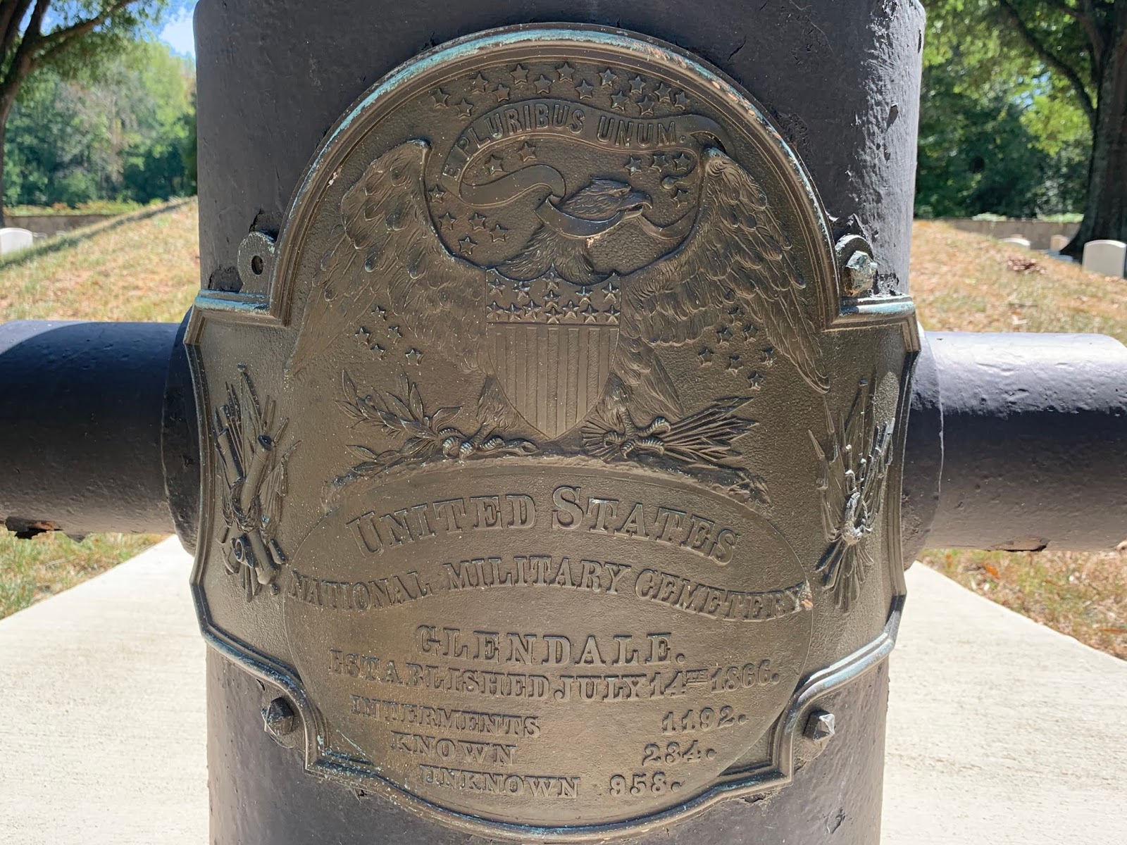
I don't know if the reader can make it out, but the brass plaque on this cannon says, "Interments 1,192    Known 234    Unknown 958"  These numbers, no doubt, speak of the Civil War dead buried here when the cemetery was established in 1866.


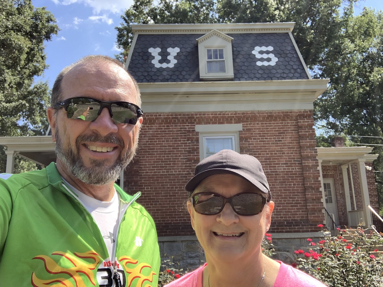
The house behind us is the visitor center for the cemetery.  I can only imagine that it was "appropriated" at the time of the burials and the cemetery later commemorated after the war.  However, they knew we were coming.  Look - that's "us" in front of the house.  Don't blame me, Susan made me put that in there - thus proving that there are bad "Mom jokes" too.


After leaving the cemetery we proceeded to our original break location - which was right across the street from the Virginia Capital Trail.  This thing is a bike trail something like 50 miles long that runs all the way to Williamsburg.  We got on the trail near the West end and will follow it all the way to its starting point before taking the Colonial Parkway to Yorktown tomorrow.  The trail was fairly heavily used, but I saw only two runners - and NO ONE walking yappers.  My guess is that this will change as we get closer to Williamsburg tomorrow - Sunday morning.  With my luck it will be yapper central.


Susan snagged this pic of me riding away from that very same break.  So, this is Sig and me on the Virginia Capital Trail.  Note the casual one-handed wave.  Used by permission of Susan Schoen photography, LLC.


The Virginia Capital Trail about 10 miles later.  It really was in good shape, and once we got away from our break location, less traveled as well.


There were a number of these wooden bridges over creeks and rivers on the way to Charles City, VA.  They make a great sound when ya ride over them at about 20 mph - which was pretty easy to do since they were always at the bottom of a small hill.


That's my "I'm enjoying myself at 19 mph" smile.


This is another in a long line of accidental screen shots that happen when I put my phone back into my jersey pocket.  Must have something to do with the way I hold my phone when I put it away.  Note that I was listening to Bon Jovi's "Living on a Prayer" at the time.  I've heard this song so many times across the country that I hallucinated on a climb in Kentucky and thought I was John Francis Bongiovi.  That's his given name, his friends just call him John.  He's known professionally as Jon Bon Jovi


This is Johnathan.  When I got to The Rig at Charles City this afternoon, Susan was already chatting him up.  She saw him riding toward Charles City as she passed him and since The Rig is parked maybe 30 ft. from the trail, she hailed him and got him to pull in as he came by.  After refilling him with water and letting him use our pump for his leaky back tire, he told me that he's a veteran (US Army) who suffered a broken neck during his service.  And he had the (huge) scars to show for it.  He described how when he woke up he was paralyzed and he still refers to himself as a walking quadriplegic.  It was obvious he had some physical limitations, but he was also at the tail end of his 600 mile tour and getting close to home.

Can't beat that for inspiration and a great way to close the day.

Till next time. 

This just in here at The Thin Blue Ride...

Saturday, September 7th, 2019

Verizon (spits on floor) is even unreliable in its unreliability.  When I tried to add the remaining pics a short while ago - it worked.  Devious jerks.

So - tonight's post will go out as usual.  We're on tight deadlines here at The Thin Blue Ride, and my editor was after me about my responsibility to the reader.  The long and short of it is that tonight's post immediately follows this one.

The Thin Blue Ride - Supplemental Report

Saturday, September 7th, 2019

My apologies to the reader, but the typical post will not be forthcoming tonight.  I've spent the last 2.5 hours trying to load pics from today and it just ain't happening.  This despite Verizon telling my phone that signal strength is running at two bars of LTE.

Verizon, bah! (Spits on floor.)

(Susan objects - to spitting - not my assessment of Verizon.)

A bigger collection of dissemblers has never been known to man.  I'll catch everyone up tomorrow night.  Maybe...  Verizon.  (Spits on floor.)

(Susan objects)

Friday, September 6, 2019

The Thin Blue Ride - Part 2 Day 90 - to Tabscott, VA to Ashland, VA

Friday, September 6th, 2019

Ride Report:  58 Miles, 4,134 Total Miles, 16.3 Avg. mph, 2,205 Ft. Climbing, 4,481 Calories.

The ride report itself is largely unremarkable - except that I can now say I rode thru a hurricane.  That the hurricane force winds were farther East is, to me at least, irrelevant.  It was a bit blustery here today, especially early, even if not as bad as it was on the coast.  And given the rotation of the storm the wind was generally out of the North, which just happened to be the direction I was heading for the first 15 miles.  This, of course, resulted in those miles sucking wind - so to speak.  But it was really no worse than a windy day back home in Kansas.  We encountered no rain, no downed trees or branches and the sun made an appearance about an hour before riding ended for the day.  I haven’t checked the forecast for wind tomorrow, but understand that the storm will be far enough out to sea that it won’t negatively impact tomorrow’s ride.  We thought that before the last day of riding we’d call the RV park near Yorktown where we plan to stay and see what they have to say about local conditions, then decide what to do. I think we’ll be OK to finish the day after tomorrow, but have read reports of some localized flooding being possible.  More on this as it develops.

Of note: As I passed thru a creek bottom today I looked at Mr. Garmin.  He was saying that the current elevation was right around 100 ft. - ABOVE SEA LEVEL.  Holy Cow!  At that elevation, if someone threw a good sized rock into Chesapeake Bay we might see the ripple in the creeks around here.  I’ll try and include a pic of the remaining elevation chart.  It’s hilarious.  That the ACA completed the elevation chart all the way to the Atlantic Coast and doesn’t have one for Kansas should be an affront to reasonable thinking Kansans everywhere.  Break out the pitchforks and lanterns, and mark your calendars - we meet at the ACA HQ in Missoula Montana on November 9th at noon.  I picked a Saturday at noon in order to increase participation.  Ya can’t just organize a protest like this willy nilly - some serious thought has to go into it first.

In fact, why wait for it.  Here's the elevation chart right now.

Just look at that "elevation" chart.  It runs from Ashland, VA (our current location) to Yorktown at the Chesapeake Bay.  There's no way Kansas shouldn't have one too.  Hey - if you're gonna get the populace all riled up, no sense leavin 'em hanging.  Best just to go for it in the moment.  My local Teamster's rep. is an expert in transportation.  Call her to arrange ride sharing to Missoula. 

But even with all this excitement over the protest at ACA HQ, one still must take care of daily business.  So, I shall commence giving you the business for today...

Me and Sig first thing this morning in front of the Mount Gideon Methodist Church where we all spent the night.  It's a neat looking building, and it appears that it was expanded at some time by the addition of the entrance behind me.  From the side you could see that different brick was used in the expansion.  Not surprising, since it was first constructed in 1852.  That's pre-Civil War for you history buffs.  The vestibule and steeple were added in 1969.  I bet they saved and paid for it with cash.


This is the parking lot and The Rig.  The little house across the street was very well kept.


It was like this a lot today.  Susan and I were just discussing last night how one of the things that we eventually tired of when last in Virginia over 30 years ago was all the trees obstructing our view.  They also interfered with Mr. Garmin on several occasions today.  So, when reflecting on the ride report as I know readers do, take the Average mph with a grain of salt.  The trees never make your speed faster, always slower. 


Another old tractor alongside the road - this one a bit more dressed up than the last one.  I believe this to be a JD 730 - although I am unsure of the variant.  The reader should be impressed that I am aware that tractor models have variants and leave it at that.  Is that a variable width row crop front end under that thing?


OK - this is a big deal.  I waited over 4,000 miles for this and there was no way I was gonna miss out on a pic with the name of the City of Bumpass on it.  For some reason (gee - I wonder why) they didn't have a big sign that said "Welcome to Bumpass, VA - Population 8,972"  This was the best I could do - the sign for the Post Office.  Susan and I have no idea where all the people are since the town didn't look like much.  My guess is that they're all embarrassed and in hiding.  Just imagine what that would be like.  "Oh look honey!  We got our annual Christmas Card from the Hildebrands.  
Yup - they still live in Bumpass."  Moving along...


Not far from Bumpass (get used to it) I ran across this old barn.  I thought it looked pretty cool.  Probably belongs to someone in Bumpass.


We also stopped in the parking lot of the Mount Olivet Baptist Church - it dates to 1849 and is in the town of Beaverdam.  (Don't ask me.)  We got to go inside.  It was way cool.


This is the view from the door to the sanctuary.  The reader should note the balcony.  Susan went inside with the Church Secretary before I got there and the Secretary told her that the balcony was used by slaves before the Civil War.  Then after the War, former slaves left the Church and started Ebenezer Baptist Church about a mile down the road.


When I got there we went inside with Pastor Dale.  We discussed the possibility of me delivering a sermon to the faithful on Sunday, but when I tried out the pulpit, it was a bit short for my taste - so I declined.  They've been here since 1849, I'm sure they'll do fine without me.  BTW - that chandelier is original and was converted from gas to electric.


This is Forks Church - named after the confluence of several local streams near which it is located.  Construction on this building began in 1736 and was completed in 1740.  That, boys and girls, is pre-Revolutionary War.  Yowza!


This is another Church on the way in to Ashland.  In all honesty, there was a sign back up the road, but I was too lazy to go back and get a pic of it.  That this is an original log building should tell the reader something about its age.  There is a wing attached to and located behind that portion of the building that appears in this pic.  It was bigger than what you can see here.


This (for a change) isn't a church.  At least not so far as I was able to determine.  Just a small log building sitting on the edge of a harvested corn field.  I thought it an interesting pic.


This is Central Street in Ashland.  There is a set of RR tracks running between the streets on either side of the tracks.  The streets are one way in opposite directions.  And in a bit of an unusual move, it appears that some of the larger (and nicer) older homes in town may be located across the street from the tracks.  I thought it odd anyway.  In this shot, I happen to be near what I'm guessing is the original business district.  In all my travels across the country on The Thin Blue Ride, this is the only time I've encountered this arrangement.


And to close out the day - this is the shot out the front window of The Rig.  RV Parks can be a case study in contrast.  Note the Allegro Bus with the full body paint to the left.  Then get out your magnifying glass and look at the small fiberglass tow behind camper by the red truck to the right.  I think the small camper would fit in one of the bays under the Allegro Bus.

So - two riding days remaining.  It's official, I'm now starting to get excited...

Till next time.


Thursday, September 5, 2019

The Thin Blue Ride - Part 2 Day 89 - White Hall, VA to Tabscott, VA

Thursday, September 5th, 2019

Ride Report: 53 Miles, 4,076 Total Miles, 15.4 Avg. mph, 3,150 Ft. Climbing, 4,441 Calories.

As the reader can see, still plenty of climbing today.  But in a bit of an improvement here at The Thin Blue Ride, it wasn't kick your butt climbing.  Just a lot of "small" hills.  And as expected, the grades are easing.  The steepest grade I saw today was 11% - on two occasions.  And both for very short distances - 6-8% was far more typical.  Those are like - kindergarten climbs.  As I was climbing one of those kindergarten hills today I actually told the hill, "Ha - I laugh at you." and spit down beside my shoe on it.  There was no response from the hill.  Typical.  They're bullies when they get bigger, but the little ones ya can still intimidate.  They are decidedly unlike Kentucky dogs - all of whom are bullies - from yappers to the larger breeds.

The wind however, made its first appearance in quite some time.  Maybe as far back as Kansas?  I can't recall for certain.  Anyway, it got a bit breezy today, probably due to Dorian coming up the coast.  Many times there were enough trees around to block the wind, but when the trees disappeared, the wind showed up.  Since we're now getting into more open countryside, the wind had plenty of shots at me today.  And it was either a straight on headwind or a quartering headwind at best.  Naturally, the last ten miles were the worst.

And speaking of wind and weather...  We're still keeping an eye on Dorian.  As of now it looks like our ride into Ashland tomorrow risks a 51%  chance of .02 inches of rain at 0800 hours and again at 1500 hours.  This according to "AccuWeather".  The last time "AccuWeather" gave me odds that good, I shoulda built an ark.  So, the plan is to ride tomorrow, be prepared for rain delays, make it 58 miles to Ashland, and lay over there a day if Dorian causes so much havoc around Yorktown that we need to let things clear up a bit.  Let the reader not forget that the terrain around the Chesapeake Bay is rather flat.  Right now the forecast calls for 2-4 inches of rain there.  I've no idea how long it takes for that much rain to drain away - that's my biggest concern right now.  We'll just have to see how it all shapes up.

Speaking of which, today shaped up quite nicely and it went like this...


First thing this morning we met this guy in the parking lot of the small grocery store where I started the day in White Hall, VA.  Susan and I both think his name is Alan, but each of us thought the other was gonna write it down.  So "Alan" - if we got it wrong, forgive us and please post a reply correcting us.  Anyway, he formerly worked at UVa which is in nearby Charlottesville.  He was a good  guy and also gave me some tips on what sort of traffic to expect getting thru town.  And he advised Susan on the route to take with The Rig, since she wasn't gonna follow me thru downtown Charlottesville.  He also knew my jersey was a K-State jersey and asked me if I knew Ron Prince!  For those who don't follow such things, Mr. Prince coached at UVa before coming to K-State.


Speaking of UVa, I think this is the main "entrance".  Hmmm... kinda looks like Jeffersons' place over at Monticello, past which the T/A route will take me shortly after leaving Charlottesville.  I decided to show some KSU pride while in town.  It worked out - neither insults nor physical objects were hurled my direction.  But I must say, students at UVa are as oblivious to traffic as they are in Manhattan.  On more than one occasion I watched them walk right in front of cars going down the street at 20-30 mph without even a glance sideways to see if a car was coming.  I've heard that the human brain isn't fully developed until one reaches their mid 20s.  College students here and in Manhattan are good evidence of that - at least as far as traffic is concerned.


University Drive, running past UVa.  I followed the van ahead of me in this pic for probably a mile or more, catching up at every light.


Lewis and Clark!  I haven't seen these two hoodlums for a while.  They're like a bad cold, I just can't shake 'em.  Who knew they discovered Charlottesville?


Highway 53 after leaving Charlottesville.  One of the steeper and more lengthy climbs of the day.  It also ran right past the entrance to Monticello.  Another of those places we need to come back to.  We'll add it to the list.  


We got a later start today than anticipated, so our second break of the day was gonna be lunch in the parking lot of the Woodridge Market in Woodridge, VA.  Instead, this is Susan paying for my cheeseburger, diced watermelon, and chocolate cake.  The reader should note the sign over Susan's head.  It reads, "ATTENTION  ATTENTION Everyone must pay before leaving the store.  Thank You."  Right after I read the sign a young man walked in and grabbed a Mountain Dew, walked to the front door, and waved the Dew at one of the proprietors, who responded, "I gotcha Boob."  "Boob" apparently being the young man's nickname.  I remember stores like this from my younger days.  One can purchase everything from a meal, to Alpo, to Night Crawlers - stored in a separate refrigerator, of course.  The burger was great, the watermelon disappeared in short order, and the chocolate cake followed suit.  


Right after I left, this guy turned off my route just before I hit the road.  We just started seeing logging trucks again over the last couple of days.  They seem to be of a kinder, gentler variety than those encountered in the mountains of the Northwest.


Ah yes - one can never get away from old machinery in rural areas.  The farmers here are like those across the country, old machinery is valued as yard art.  So it's official, old machinery as yard art is a phenomenon from coast to coast.


Shortly, I ran across this place.  According to the sign, a fully restored Victorian house.  Way cool...


...and also for sale.  If you're interested, the number is right there.  Just give the agent my name so I can be sure to get my commission.  Gotta pay for the trip somehow.

And as an added bonus, this cemetery is nearby.  These things dot the Virginia countryside.  Just think of the convenience; buy the house and when your time comes its just a hop skip and a jump (Well, not for you, but for everybody else.) to the cemetery.  This is why I'm so good at sales.

So - we made it to Tabscott, even if a bit later than planned due to our late start.  It was an uneventful day - which is always good, and we'll hit the road early again tomorrow.  This pattern will persist for three more days, then we may hit the road late for the rest of the trip so I can catch up on my beauty rest.

Till next time.


Wednesday, September 4, 2019

The Thin Blue Ride - Part 2 day 88 - Misty Mountain Campground (Rest Day)

Wednesday, September 4th, 2019

Ride Report: None - Rest Day

By this time the reader knows that we do laundry, wash bikes and other miscellaneous chores on our day of sloth.  As a result, I shan’t bother repeating that blather.  Instead, I thought I’d provide a snapshot of the remaining 4 riding days, give you all a quick look around the campground, and briefly discuss our post ride plans.  Said plans being, at this point, still in the formative stage.  But first, a confession.

Last night I got the first of what I suspect will be repeated occurrences of the butterflies concerning the end of The Thin Blue Ride.  Nothing earth shaking, mind you, but they made a brief appearance none-the-less.  In the run-up to the ride, the trip to get to Oregon and subsequent riding; life has pretty much been consumed by the ride.  No time for butterflies.  And tho there may be among you those who will scoff and suspect I am self aggrandizing, I’ve concluded that it takes considerable mental discipline to ride one’s bicycle across the good old USA.  But, what happens when the very action necessitating that discipline abruptly ends?  This was the nature of my angst last night.  The ride has been a struggle at times and a thing of beauty at others.  But in my assessment it has, mostly, been worth the effort.  “One thing that cycling has taught me is that if you can achieve something without a struggle it’s not going to be satisfying.” (Greg LeMond).  Is it possible to miss the struggle?  Upon reflecting on The Thin Blue ride, will I be satisfied?  That is what the butterflies were settling amongst themselves last night.  I suspect they’ll let me know when the time is right.  And when they speak, I’ll pass it along.

Holy cow - heady stuff there readers.  My apologies.  So, try and keep your confusion in check, it’s still me here.  I just wonder if I’ll miss it.  I think the answer is probably yes and no.  But I can say that I’m looking forward to the post ride trip home.  For reasons that will be made evident below.

Speaking of which - here’s what remains of the ride...

This is a screenshot of a Google Maps route to Yorktown.  The route starts at the top left and works to the bottom right.  The blue dot at the top left is our current location at the campground.  Susan will drive me back to White Hall where I stopped yesterday so that I can continue from there tomorrow.  While the stops listed at A (Tabscott), B (Ashland), C (Charles City) and D (Yorktown) are accurate, the route - not so much.  But it does get the point across. 


And now on with today...

The Rig at the campground.  Just when ya think you've finally arrived in life, ya look across the street...


...and realize that no matter how many apples are in your pie, there's always somebody with a bigger pie.


It's hot and humid (again) here today, so it was a good day for a Rest Day.  But it was still cool by the creek that runs thru the campground.  It's just a small creek, but it's clear and I like the ripples in the foreground between the leaves.


Nobody out there in the sun right now, but this is a campground with some pretty nice amenities.  In this shot there is a tented meeting space to the left, a kid's playground in the center, a clubhouse and office, and an elevated stage to the right.  What doesn't show up is the pool and the splash park behind the clubhouse/office.  That's right readers, all this for only $55 per night.  It's enough to make me want to open an RV Park.  If I do you're all invited - for $55 a night.


This is the park's tenting area on the other side of the creek.  Each of these sites has electricity and an elevated platform to get either your tent or your picnic table up off the ground.  Maybe both - if ya have a small tent.


Me - standing on the bridge over the creek.  C'mon.  By now the reader should know that I'm a sucker for the bridge/water combination.  They make me...serene...


This, readers, is how ya can tell the high class RV Parks from the pretenders.  That's right - ducks.  It works like this: ducks are better than no ducks,  more ducks is better than a few ducks, white ducks are better than non-white ducks - unless the non-white ducks retain their wild counterpart's colors.  Then, multi-colored ducks are better than white ducks.  Net result - this place is moderately upper crust.  Now excuse me while I go hob-nob with the neighbors in the tiny house.

Right now the post ride plans have us hitting Yorktown for several days to see the sights and have some time to unwind from the trip.  It will be unusual to spend more than a day and a half in one location.  Then on to Newport, Rhode Island for a bit.  And with Cape Cod just around the corner (both figuratively and literally) we'll spend some time there.  Then it's off to Lake Champlain in Vermont for several days.  Finally, a stop over in St. Louis on the way back to visit Tim and Glynda Gasser - friends from BK (Before Kids).  As it stands now, we will have maybe three additional days to burn in there somewhere and we've yet to figure out what to do with them, but I'm sure something will come up.

Till next time.


Tuesday, September 3, 2019

The Thin Blue Ride - Part 2 Day 87 - Vesuvius, VA to White Hall, VA

Tuesday, September 3rd, 2019

Ride Report:  47 Miles, 4,023 Total Miles, 13.0 Avg. mph, 4,511 Ft.Climbing, 3,958 Calories.

Well, let’s get right to it readers.  There are really three stories to the day.

First, and as expected, Vesuvius sucked.  I had done the math on the total elevation gain and figured the average slope to be 8.8%.  When the first half mile ran 4-6%, I knew the mountain was gonna make that up somewhere.  Somewhere turned out to be pretty much the rest of the mountain, save for the last .2 miles.  Everything between the first .5 and the final .2 was between 9% on the low end and 13% on the high end.  Though I did see 14% for a brief time.  If I had to pick an average slope for those 3 miles, I’d say 11%.  I covered the total 3.7 miles in 41 minutes.  What a sufferfest.  I’ll have some pics that will tell the tale...

...but the story starts here.  This is the elevation chart for today.  We started at Vesuvius on the left and went about as far past the red line to the right as Afton is to the left of that same line.  FYI - the black horizontal lines represent 1,000 ft. of elevation.  We won't see anything approaching 1k of elevation until we start the post ride trip.

Second, The Thin Blue Ride surpassed the 4,000 mile mark today!  Thank you, thank you - please hold your applause until all the awards are announced.  Speaking of the 4K mark, Delta and I had the honor to reach that lofty mark while on...

Third, The Blue Ridge Parkway.  Wow!  The ACA nailed it by putting the Parkway on the route, if only they could figure out some sort of shuttle service or something to get ya up there.  The Parkway numbers its miles from North to South.  We came on at mile 27 (South) and rode to mile 0 (North).  We were doubly fortunate because there were observation areas all along the route.  Susan had mapped them out and knew how far it was from one to the next.  (The Teamster's motto is apparently, "Always be prepared.")  I told her last night that today was gonna be treated like a vacation day from a ride perspective once we reached the Parkway.  Meaning that we were going to take time to stop and smell the roses - and to get some pics like we did on the Oregon coast.  Oh yeah - and the Parkway was basically empty for the first hour.  It was amazing.  Even later when the traffic picked up, it was never so much as to be a bother. 

There was a lot that was photo worthy today, so (for a change) I'll try not to be too wordy with the scenery pics and let them speak for themselves.  All other pics are still fair game tho...

These three showed up for today's early start.  When I asked, they said another deer sold them tickets to watch some idiot try to ride up Vesuvius today.  I dunno... they're deer - the same animals that run in front of cars - who knows where they get these ideas.


Mr. Garmin asked to be included in today's post.  This is what he had to say before the first pedal stroke of the day.


This is me about half way up Vesuvius.  I had to stop...for some water.  Yeah, that's it - water.  Actually, I was a bit winded, sweat was running into my eyes and mouth from my headgear and ya really do have to stop to drink when the grade is so steep.  It's hard to get the bottle out of the cage and back in without tipping over when you're goin' so slow.  There was no smiling to be had.


This sign marked the final .2 miles where the grade lessened to maybe 6-7%.  It felt like I was going downhill.  I really did try and smile for this one, but it just wasn't gonna happen.


Susan snagged this one of me passing under the bridge for the Parkway.  That's one impressive bridge.  I don't know that I've ever been happier to see her and The Rig on this entire trip.  (Used by permission of Susan Schoen Photography, LLC)


This is what Mr. Garmin had to say when we reached the top.  And no - it wasn't raining today.  This climb was so tough that even Mr. Garmin sweated it up.  He was moaning and complaining.  I told him to wipe down and rub some dirt on it.  The reader can do the math on the elevation gain.  Interestingly, Garmin showed both the starting and ending elevation of the climb as being a few hundred feet less than the ACA map.  The difference is about the same tho. 


Scene #1 from atop the Parkway.  This gives the reader some idea of the lay of the land.  BTW - the Parkway is not flat once ya get up there.  There was still plenty of climbing to do.


Delta and me at a pull-out Susan couldn't get into with The Rig.  Some family of bicycles on vacation happened to pass by and Delta asked one of the kids bikes to take a pic for us.


Susan and me with a nifty valley in the background.


Susan also snagged this one of me arriving at another of the pull outs on the Parkway.  Check out the backdrop between the trees.  (Used by permission of Susan Schoen Photography, LLC)


Delta happened across this - the Appalachian Trail.  It crosses the Parkway several times.  He thought that once we finish the T/A we should do the A/T.  I tell ya, the bike has more energy than brains.


The view from the Three Ridges pull-out.  The A/T came out over to the right of the pull-out...


...and went back into the forest on the other side of the road.  Unlike Delta, Susan and I can now say that we've hiked a portion of the A/T.  "Portion" apparently being Latin for "20 yards".  I wore my helmet for safety reasons.  Susan?  She's a daredevil.


Delta - with the Shenandoah Valley to the West and 1800 feet below.  This was an amazing view.  Reminder: the climb to this height was on a bike!  Holy mother of pearl!


It went on - the valley is quite long and there several pull-outs from which one could view it.

Susan and me with the Rockfish Valley behind us.  This view is to the East and came shortly before we exited the Parkway.


I hadn't had one like this taken in a while, and I was wearing my Trans/Am jersey, so the timing seemed good.  That's the same Rockfish Valley in the background.  (Used by permission of Susan Schoen Photography LLC)  But she forgot to ask me to sign a waiver so there may be issues later.


From left to Right: Angelo, me, Frank and Ray.  Angelo and Frank were traveling together and just met Ray a half hour earlier.  They're on a road trip - and as it turns out two other bikers showed up after we took this pic.  It was then that they learned they were going the wrong direction on the Parkway.  They took it in good humor - probably better than I would have.  Frank picked Delta up and was surprised how light he was.  I didn't try it with his bike.


After we came off the Parkway, there were a number of small state highways which led to White Hall - our destination for the day.  This was one.  I tried this shot to give the reader of the slope of the roads around here...


...but maybe this one does a better job.  And no - this is not a pano shot of a straight road.  I think the inside edge of that hairpin drops 6-7 feet.  And at both ends of the visible road - you guessed it - another hairpin.  This was a really steep section of road.  Fortunately, after coming down off the Parkway, most of the rest of the day was down hill - as was this road.  Thankfully, Susan had taken a different route.

So - a tough start to the day, but that was expected.  When I got into The Rig after Vesuvius I told her, "This Blue Ridge Parkway better be all it's cracked up to be."  It was.

Till next time.