Ride Report: 64 Miles, 1,858 Total Miles, 16.8 Avg. mph, 2,533 Ft. Climbing, 4,829 Calories. Today's top speed = 43.7. The Thin Blue Ride has provided some fun descents lately. I know I hit 40+ two other times today, but the Garmin only tracks the top speed unless I wanna go digging thru graphs. Bah - not me. I've not the patience for it.
Recall that today started with a climb to yet another Continental Divide. I think this is 7 or 8? Who knew we had such a divided country? It was about 5 miles of 5-7%, and it was plenty cool when we started. I think around 47 degrees. I know I've said this before, but once the first 5 minutes passes, that's a perfect temperature for climbing. The problem is with the descents - a bit nippy...
We stayed on Colorado 125 again today, and a more abominable imitation of a highway I've yet to meet. From the time we got on it three days (?) ago there were pavement cracks every 30 feet. An NFL down and distance crew couldn't be so regular. And some of these cracks were 3 inches wide with a drop of two inches. When ya hit a pavement crack and your helmet slides down over your eyes, you know you've hit a pavement crack. Good riddance. We turned off of 125 and onto US 40 just South of Granby, CO. A much nicer road. Most of the time with excellent shoulders upon which to ride as the people in four (and more) wheeled vehicles roared past on their way to do...stuff...stuff worth roaring past for. I dunno. This retirement thing has made me forgetful.
So here's the day in a nutshell...
The Continental Divide - I somehow managed to snag some excellent company for this pic. She was there waiting. What are the odds?
Again - excellent company. Delta doesn't see too many Continental Divides, but this one wasn't especially strenuous. And it was his turn. Note the arm warmers, vest and tights. (I can't believe I just said tights, much less that I'm publishing a pic of me wearing them. Henceforth they shall be referred to as "riding pants that keep my legs warm".)
This was a cool rock outcropping that we ran across at another rest stop, where there was also a little bridge over...
...a creek. Forty years and we still gotta learn those shadows how to behave in public. Next thing ya know there will be gaggle of little shadows running around. And no - I don't have a big head. I'm wearing my helmet.
Starting to see some interesting rock outcroppings along the river we're following to Kremmling. It's been a while. Delta was tempted to go plant some sage brush on the side of that rock.
It warmed considerable after we hit US 40 - note that all the outerwear has disappeared. This narrow "valley" was entirely covered with grass - and was entirely filled with standing water - which was entirely filled with mosquitoes. These things are a plague the likes of which hasn't been since wince hand carts worked the streets of Europe picking up corpses.
And there was also Byers Canyon. It was narrow, had a high rock wall on the right along with a railroad track, tree covered slopes on the left, the Colorado River ran down the center, and it was all downhill. Downhill enough that we only got passed by one car on the way down. It also had enough turns to make it interesting, but not so many as to detract from the view. And it went on for five miles. We're still on US 40 South of Granby in case the reader is ever out this way. It's worth a look.
I couldn't help myself - this another shot of me in Byers Canyon. Once again the T/A route planners got it right. Just amazing views. Do those glasses make my nose look big? I don't know that Susan would tell me if she thought so...
We stopped for lunch in the parking lot of the Parshall Inn. Parshall is a pretty small town, but if you Google Map it, it shows up. Good thing I have Willie on my contacts list. I'm not sure he knows. I'll have to text him and fill him in. I hope he's not drunk again when he texts me back. His messages are so scrambled as to make them incomprehensible at three in the morning. I've been to Luckenbach Texas (See the Texas Test Flight) and just don't see what he gets out of the place.
Lots of uphill today. This will be the case until we reach the top of Hoosier Pass.
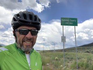
Speaking of which, now we're at least in the same County as Hoosier Pass. I've gotta say, we spent a lot of time in Summit County as a family when the kids were little - mostly skiing every winter. I've never seen the North part of the County before. My assessment - it's quite striking and well worth the reader's time to make a trip out this way in the summer.
OK - so tomorrow gets us to Breckenridge in about 45 miles. We hope to make it there in plenty of time to set up camp, clean the "house" up a bit (Got comp'ny comin' doncha know.), that sorta stuff. We'll have to see if an early arrival comes to pass or not. The winds aren't supposed to be particularly favorable tomorrow. As a result, the reader should be prepared for a good bit of whining by...someone.
Till next time.


No comments:
Post a Comment