
I know I typically start with a ride report. Today I'm gonna start with two ride reports. And while I understand that I said supplemental ride reports would remain an anomaly, the second is not a supplemental report. They're both part of the same long day. I'd like to delude the reader into believing that I did this intentionally, but the truth is I accidentally shut off the Garmin and had to restart it - which created the second ride. This was fortuitous as the point at which I shut it off was at a distinct divide in both the geology and climate encountered during the day. Additionally, the first report encompasses the climb and descent of Mt. McKenzie - nothing more, nothing less. So - the ride reports:
Ride Report 1: 30 Miles, 334 Total Miles, 2,904 Ft Climbing, 2,463 Calories, AND Mt. McKenzie. More on this vile monstrosity later...
Ride Report 2: 46 Miles, 380 Total Miles, 1,040 Ft. Climbing, 3,618 Calories. And one forgiving wife. More on this later as well...
So, all in all 76 miles, 3,944 Ft. Climbing and a 6,081 calorie day.
Well, as the reader knows I've been carping about Mt. McKenzie interminably. Today was the day. Susan dropped me at the turnaround point for over sized vehicles and I was off. Closed road to the contrary, I tried to convince her she should just follow me with The Rig. I was rewarded with this look...

Its a look I'm familiar with. Unless I've been misinterpreting this look for the last 40 years, she's makin googly eyes at me.

This is the road up McKenzie at the start. The grade isn't too bad here yet - running 4-6%. Forgive the hazy nature of the pic. The phone was in my back jersey pocket and I think the lens was fogged from the sweat. This is a combination which bodes ill, the grade isn't steep yet and already the lens is fogged...

But in short order the grade kicked up. Within a half mile of starting I was looking at minimum 6%. If I had to say, I'd peg the average at 7-8% with some pitches up to 10%. And this went on up to the 8 mile point. Ouch. The discerning reader will note several things concerning this pic. 1. I'm still smiling. The reader should not be deceived. I've learned how to smile between gasps of air. 2. Note all the undergrowth in the forest behind me. This is actually a rain forest. There are ferns everywhere. 3. Note the patch of grey between the two big tree trunks. That's the road I just came up. There is a hairpin curve behind me (out of the pic) and I'm looking down some 80' to where I was just moments ago. That, readers, is steep!

At 4,000 ft. its game on baby! Reader's choice: I'm either making my mean face, or I mistimed the pic and am gasping for air again...

Wait a minute - what's this stuff doin here in June?

Interestingly, at the 8 mile mark the pitch leveled out and ran thru what I guess I'd call a meadow that had suffered a fire recently. There was still some work to be done, but the heavy lifting was pretty much done in the first 8 miles.

Once past the burned area, the meadow looked like this. It was stunning. Only problem was that when one stopped for a pic, the mosquitoes latched onto you like ticks. Except that they were larger and meaner.

As we neared the summit, we started seeing the lava flow that apparently covers the summit.

Just before the summit there was an observation area where one could take in the "Sisters" mountains. The juxtaposition of the snow capped Sisters with the lava field in the foreground was stunning.
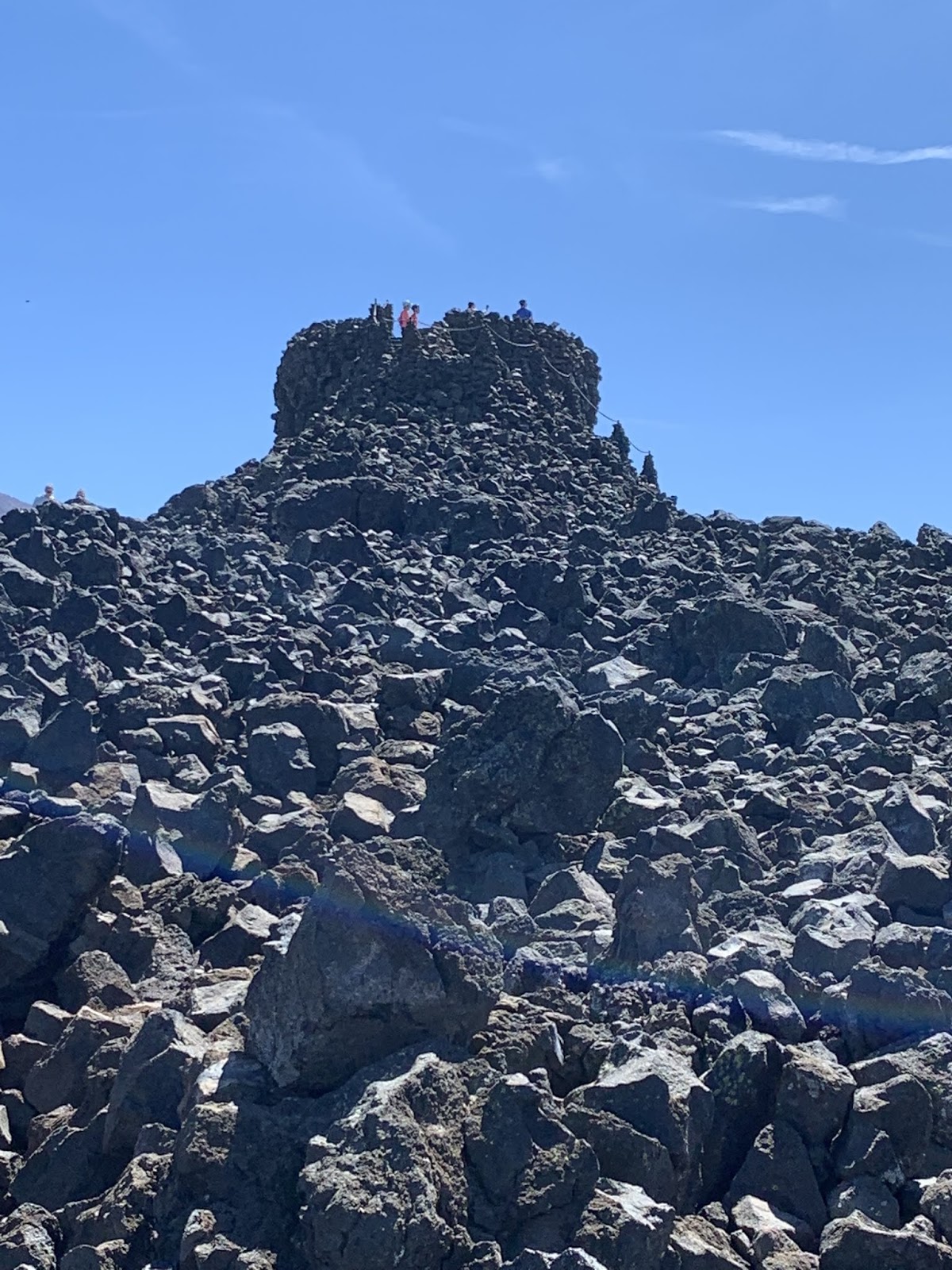
There was also this just before the summit. It's the Dee Wright observatory. I'd heard of it, and anticipated a star gazing thingy. Nope, it's there to keep an eye on the lava field. There were what looked like flagged survey markers out in the lava field. My ACA map says that its been determined that the lava flowed about the same time the Pilgrims were getting off the Mayflower. Interesting.

And here we are at the summit. The inquisitive reader may have been curious as to my choice of jerseys in which to climb the mountain. When I bought it , it was sold as the "Global Warming" jersey, and yes - that's the fireball from a nuclear explosion on the front.
So, my McKenzie report. It was a tough fight. I clearly held sway in round one, the first half mile. Round two was a slugfest with both McKenzie and I getting in our licks. But by round three, the big guy wore down and I'm smiling at the top. For real smiling. The pic below is part of the print on the back of the jersey. I wanted McKenzie to see it as I coasted away downhill.

We know how this fight turned out. 'Nuff said.
The downhill was interesting in that the climate (and hence the forest) changed completely. Gone were the frequent rains - and with it the ferns. No rain forest on the East slope!

Within 25 miles of the peak of McKenzie, I was looking at this. That, readers, is sagebrush. Oh - and some spindly looking sorta cedar tree thing. Nasty. And as an added bonus, it was hotter as well.

They also have some interesting crops in these parts. I'm a ways off from this field, but to my discerning eye, these appear to be marijuana plants. That's right reader, the devil weed, wacky tobaccy, mary jane, the list goes on. I don't think we're in Kansas any more Toto...

At one point I turned around and looked West. This is where we came from.

And this is where we're going. Pretty much sums it up.

Which is not to say that the area was bereft of neat photo ops. Eastern Oregon thus far appears to be a story of "where's the water"? Along the river its very lush. Away from the river - not so much...

One last look at the cascades. Used by permission of Susan Schoen Photography, LLC. She took this one at Sisters, OR. Gorgeous.
I believe I mentioned earlier that it was hotter East of the Cascades. So after leaving Sisters, I had 26 miles to go to get to Terrebonne, OR. where I was scheduled to meet Susan. We thought it a good idea just to check in before she headed on to Prineville some 20 more miles down the road. This turned out to be a good thing. I had run thru most of my water by the time I got to Terrebonne and had been rationing it for the last 5 miles. It was hot and I had to wait 10 minutes to turn left onto 97 highway due to heavy traffic. I thought I got lost in Terrebonne (a city of - well - not very many people). I find it prescient that just a few days earlier I had described myself as cranky when I get hangry. Susan said no - I get cranky when I'm dehydrated. I was dehydrated now. I later apologized to Susan for being cranky when I got to Terrebonne. She said it wasn't a problem because she knew what was going on. I have this maxim - All men marry up. I certainly did.
Anyway, we both decided I needed a break and some time to cool down before the last 20 miles in to Prineville. Fortunately for us there was a restaurant right across the street from the church parking lot where she had stashed The Rig. It resulted in this

The reader will note that half of my elkburger is already gone in this pic. You read that right - elkburger. Half is gone because I wanted to be able to report on its merits rather than just posting a pic of some plate of food. I'd give it 4 stars. After about an hour, two Diet Pepsis, Two Diet Cokes, and a glass of water that I looked at, I felt much better. On to Prineville!

The remainder of the ride followed the Crooked River (No - I'm not describing it. That's its name.) into Prineville. This is always a good thing as it means a steady downhill slope of at least 1%. Just what the Doctor ordered at the end of a long day. But first I had to descend to the river bottom. The bluff you see in this pic was right out of the church parking lot and followed me all the way to Prineville. Very scenic.
Till next time.
You are tramping around near my ancestoral stomping grounds. My great-great grandfather arrived in Oregon in the early 1840s. Keep an eye out for the Applegate name as he married the daughter of Jesse Applegate.
ReplyDeleteChuck Putnam
Just googled his name. So one of your relatives married into mid 19th century fame eh? Whodathunk? So -are you in line for any Applegate inheritance fortune?
DeleteThese photos are breathtaking!! Wowza! What a beautiful mountain.
ReplyDeleteThis is Melissa Harstine. Not sure why it says Unknown, because my name/email is listed below "reply as" and above the button that says Publish. Hmmm....
DeleteYeah - this is a mystery to me. I've checked the set-up of the page several times and can't find anything that would let me control it. I may have to check with technical support (Kelsy - our daughter) when we see her in Breckenridge. Apologies.
Delete