
Ride Report: 65 Miles, 3,746 Total Miles, 13.5 Avg. mph, 5,390 Ft. Climbing, 5,381 Calories.
I have several observations concerning today's ride report. 1: Given how today shaped up I was nervous going in what with my melt down the other day. 2: Apparently each foot of climbing roughly approximates one calorie - at least for today. 3: That's a pretty darned good average speed for me given... 4: The amount of climbing today - Garmin says that's the biggest daily total yet for this trip. I may have had more climbing in one day a number of years ago when I rode the Copper Triangle in Colorado and did three mountain passes in one ride. But that Garmin died and the numbers are lost to history.
I am also pleased to report that despite all the climbing and the longer ride distance today, Virginia is starting to grow on me. When we talked about it, Susan said she felt the same way. And we both attribute it to the same thing - ya can actually see some scenery instead of just the trees beside whatever hill ya happen to be standing next to. Speaking of hills, they are by all appearances less severe. The climbs less short/sharp and seem to be more gradual and a bit longer. The highest slope I ran across today was 12%. A far cry from yesterday's 16%. It also didn't hurt that the sun came out fairly early after the ride started today - and that it did so with no resultant increase in the temperature. I think today's high here in Damascus, VA was 79 degrees. Tho my nose is a bit red tonight. (Yes daughter of mine - I put on sun screen. But apparently it sweats off quite easily. And I sweat a lot today.)
But the big plus in Virginia is that while people still have dogs outside their residence, they either leash them or have fences that prevent them chasing me. So today when they ran (inside the fence) barking at me, I barked back. So there.
So since it was such a good day today, let's get right to it...
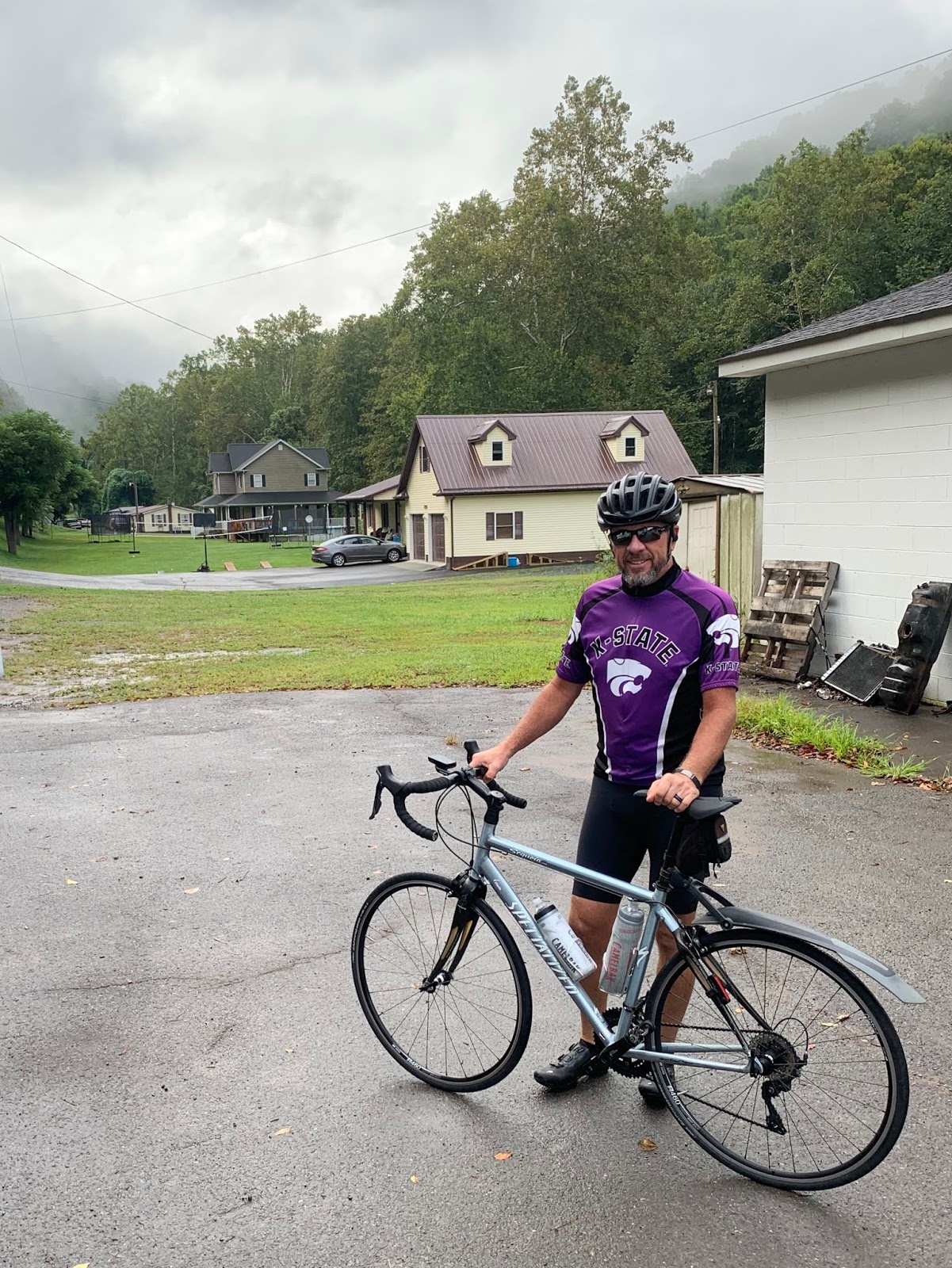
The morning started out like this. In all honesty, I was not looking forward to the day. It rained off and on most of the night last night. As the reader can see, it was wet out of the gate today. This resulted in resetting the alarm (which was good) and a later start to the day (which is bad) thus putting us in Damascus later in the day than I would have preferred. So, it was wet and I was cranky early. Good thing Sig is a mudder (a horse racing term). Note the long rear fender. He hates wearing it.

But between 10-15 miles down the road I ran into this guy. For those interested in such matters, I believe this to be an excellent example of the Eastern Red Spotted Newt (notophthalmus viridescens - God bless the internet) in its eft stage. Note the lack of gills. He was actually the second one I saw. I was moving fast downhill the first time and didn't stop. But this one I saw on an uphill, hence the pic. I would say he's about 2.5-3 inches long. When I asked, he said he'd hold up for a pic if I'd make sure he made it to the other side of the road. Deal.

This small stream beside the road was very interesting. The rocks, having been shaped by water, almost looked like ripples themselves. It should give the reader what underlies the top soil around here as well as how thin the layer of topsoil is.

This is what I meant about being able to see for a distance again. Ignore, for the time being, that we'll eventually have to climb that range of hills behind me and the pic is very cool. I don't recall which climb it was today, the Garmin told me that the summit was 3,006 feet. that's the highest we've been since western Kansas. I always find it amazing that tho the altitude is approximately the same, the topography is so much more severe here.

OK - I'm a sucker for a good lookin caboose. I found this one leaving Honaker, VA. I think the last one I saw was somewhere in Montana, maybe?

One of the few sections of relatively flat road around here. And as always, we eventually need to get over those hills in the distance. As an aside, the reader may note that Sig has reappeared in the blog. I was beginning to experience some fairly severe pain in both shoulders. As is typical, when I told Susan she inquired quite extensively and then concluded that it might be that my riding position on Delta is OK for a while, but could eventually cause the sore shoulders. When I started thinking about it, I realized that with the exception of two days in Kansas, I'd been riding Delta exlusively since before Breckenridge, CO. Sig sits a bit more upright than Delta - this apparently helps. After riding Sig for a few days now, I've noticed that the soreness is already dissipating. Susan missed her calling - but now that the Teamsters have their hooks in her, I fear it's too late.

This pic was cool enough when I stopped to look at the clouds. The reader should really look at this pic full size. I've never seen clouds that look so...bubbly? I don't know what to call that. But when combined with the road disappearing into a dark hole in the trees? It was just eerie. I expected to be accosted by trolls, or goblins or something.

Yet another scenic vista. I can't describe how nice it is to be able to see things, anything, in the distance. Even if it's just more hills.

I really liked this old tin roofed barn what with it being back stopped by the tree covered hill.

OK - this is a big deal. The reader should note how the two mountains in the distance taper toward each other, creating a gap. The old church sitting there is kinda cool too. This is Hayters Gap. The small town of Hayters Gap is about a mile behind me. These naturally occurring "gaps" in the mountains facilitated westward exploration and expansion. It's also a big deal for T/A'ers as there's a heck of a climb to get here.

This was just so fun I had to take a pic. It was amazing to enter these areas. The ambient temperature would drop considerably - maybe as much a ten degrees. The dappled light is also on the cool side. I smiled all the way thru this part of the route today. That's been a while coming.

This was the final rest stop of the day. I'll quote Susan's consideration of the two possible sites. "Well, there was a church and a truck stop. The obvious choice is the truck stop." Of course it is...
From this point she took a different route because the T/A route was questionable for The Rig. I met her 13 miles later in Damascus. And while I'm on the subject of The Rig and the roads upon which she drives it, I've been quite proud of her recently - and especially today. On a couple of occasions today she was driving on one lane roads with switchbacks going up and then down the side of mountains. On both occasions she had gone on ahead of me and when I saw the roads she was on I prayed. On the second occasion (a downhill) I was relieved to meet her at the next scheduled break location. I was greatly worried that even if she had made it successfully, she'd be all fretted up. She was fine. Those Teamsters are a tough bunch. Pretty much nothing phases 'em.
Till next time.
I wouldn't worry about trolls or goblins. But if you hear banjos playing, I'd probably shift gears and start pedaling. Lol
ReplyDeleteI sent Susan thru with The Rig first - scared 'em all off. Nobody argues with a Teamster.
Delete