
Ride Report: 68 Miles, 3,069 Total Miles, 15.7 Avg. mph, 4,331 Ft. Climbing, 5,816 Calories. Author’s thoughts: With 4,331 ft. of climbing and a 68 mile day, I’ll take that 15.7 average speed, baby, all day long and in spades.
The main action today had us leaving Missouri and headed into Illinois. The reader can anticipate the appropriate state line pics below. It didn’t take long to leave the major hills behind in Missouri. Tho the climb out of the Mississippi River valley on the Illinois side was no piece of cake. But from that point on, the % grade of the hills became less and less severe. Oh sure, there was the occasional rogue hill with an attitude, but even they were posers compared to Missouri.
But before we commence, let me say that I took a highly unusual pic just before leaving Missouri. I already had my phone/camera in hand when I came around a wooded corner and saw a naked lady. Right there in the front yard of the house by the road! Well - ya don't see that every day. So I did the only thing I could think of... I took a pic. C'mon! If I didn't, nobody would believe it. However, in the interest of keeping things here at The Thin Blue Ride family friendly, I have elected to post this particular pic at the end of the blog. I've also put it a good bit lower and after the usual closing line. If you want to see it, you'll have to scroll down. If you have small children who read the blog, send them to bed before continuing...
With that out of the way, today's adventure looked like this...

Parts of Missouri open up and one can see for a good distance. On the T/A, those parts are the "plateaus" between river or creek valleys. This is one of those places. I thought it worth a pic. Additionally, the pic serves as an excellent segue to my discussion yesterday concerning the confusing array of numbered/lettered highways in the state of Missouri. The following list was compiled from just one map segment out of the three we traversed today: N, 21, O, 32, 221, NN, U, BB, B, 67, D, EE, OO, F, H, and finally, AA. First, these highways are arranged in a manner much similar to that of a bowl of spaghetti thrown wantonly on the floor. Second, it appears that a dyslexic fourth grader was hired to name them.
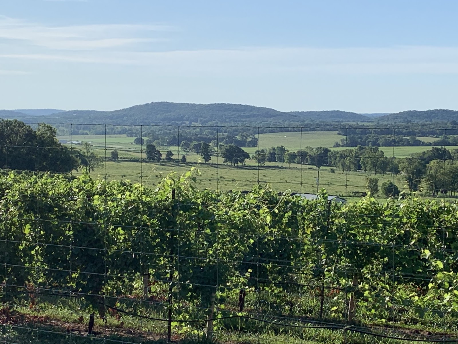
Still in Missouri - and if my trip thru California in Part 1 of The Thin Blue Ride taught me anything, it is that these are grapes. I'd heard rumors of a burgeoning wine industry in Missouri. Apparently they're true.

I think this was the last 12% hill I encountered in Missouri. I now know why we Kansans refer to Missouri as "Misery". That's my best Michael Jordan tongue hanging / hill climbing face.

The reader may recall Delta in a pic with a downhill curve disappearing behind the trees from yesterday's post. This is the opposite - an uphill curve disappearing behind the trees. These aren't as much fun - the only question being for how long the uphill goes on behind the trees. The answer: too long.

This, readers, is our first peek at the Mississippi River Valley. Kinda a big deal. BTW - there's a lotta corn down there.

See - a lotta corn. Finally - some flat land. Blessedly flat. I cruised along at 20-23 mph here.

OK - we're gettin close now. Delta was all excited.

OK - I was a little excited too.

And here it is. That's right readers; The Mighty Mississippi, The Ole Miss, The Old Man. (Internet bonus points to the first reader to name the movie and character from whom I purloined that line.) BTW - taken by yours truly while riding across possibly the worst bridge between two states in the ENTIRE United States of America. It was horrible. Concrete spalling, rusted re-bar visible in numerous locations, potholes, humps where there were formerly potholes, narrow. Wow - it was a mess. Thus making even more amazing that I got off this great pic - which was also...

...shot between the girders in this pic. I really need to take this up for a living.

But once we made it to the other side, we had our chance at the "Welcome to Illinois" sign.

Which, of course, necessitates bringing in Susan and her spare hand. State number eight! Two more to go. The reader will just have to tune in every day to find out which ones. Hey - it's either that or go find a map on the internet. Personally, I think the reader will learn a lot more here on The Thin Blue Ride. It will certainly be more interesting. Especially today...

And did I fail to mention that Chester, IL (the town at the Illinois end of that horrible bridge) is the home of Popeye? Well it is. So there. If'n ya don't know Popeye, Olive Oyl, Bluto, Swee'Pea, Wimpy and the rest of the crew, your education is sorely lacking. Either that or you were born after about 1965.

This is me beside the Mississippi River. Right beside the river. I wasn't supposed to be here. Susan prolly thinks I got lost again. I don't know how that could be since I was right beside the biggest river in North America, right at the line between Missouri and Illinois, and in Chester Illinois. Lost. Bah! How hard could it be to find on a map? Besides, I got this great pic. And it only cost me an extra mile and one additional 12% hill. I choose to call it an adventure.

I earlier mentioned the climb up out of the river valley. At the top, there was some sort of Popeye Museum on State street where it joins highway 150. I think this is a statue of Wimpy, though it looks nothing like him if one knows him personally.
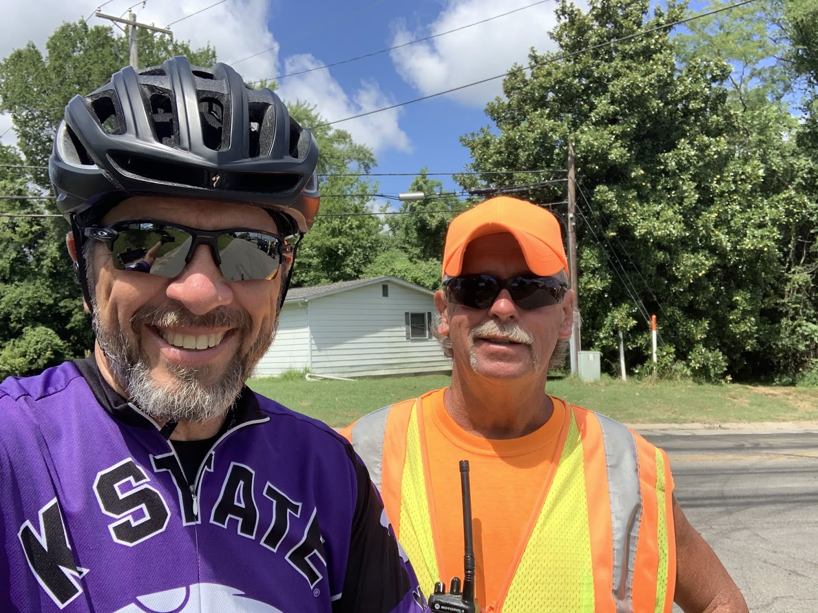
This is Dan. He was at the corner of highway 150 and "County Farm Road". He was controlling traffic continuing on 150. At the time I thought I was lucky to be turning on to County Farm Road (CFR). I soon learned that the same guys in charge of the bridge were in charge of CFR. When Susan (ahead of me in The Rig) texted me and told me to look out for the half mile of gravel at the bottom of a hill a short distance out of town, I knew the next 10 miles were gonna suck. I was not disappointed. By the way - that Dan really knows how to wear a ball cap and sun glasses, eh? The reader should note the 180 degree bend to the brim and the extra dark shades. I like this guy. He reminds me of somebody...

CFR - Lotsa soybeans hereabouts. Tall ones. They must get plenty of rain out here. Of course, that might also explain the washed out, graveled, half mile of road I just walked thru.

And in Susan's continuing saga of narrowing roads... When I got back to The Rig tonight, she was raving about even narrower roads. Then she shows me this pic. Mmmmmmyeah - there might be something to this. I'll contact the Road Width Measuring Department here at The Thin Blue Ride and see if they have any ideas about what's going on. BTW - she just stops in the road to take these pics. For such a low risk, safety conscious person this is inexplicable. I don't wanna hear any more about me taking pics while riding a bike. She's standing in the middle of the road to take a pic, for God's sake.
And here we are in Illinois.
Till next time.
*
*
*
*
*
*
*
*
*

See - told ya - naked ladies.
Hahahahahahahaha - I'm hilarious!
Hahahahahahahaha - I'm hilarious!
Clark Griswold in National Lampoon's Vacation.
ReplyDeleteDing, ding, ding. We have a winner. IPBs have been added to your Amazon account. On your next Amazon purchase, use the coupon code BS (my initials) at checkout.
DeleteI am also guessing that your final two states will be Kentucky and Virginia.
ReplyDeleteWhen I lived in Illinois I ran in the annual River-to-River Relay twice. 80 miles across southern Illinois from the Mississippi river to the Ohio river (Wolf Lake to Golconda). I have an idea of the terrain you will be riding through.
I just Google mapped your run route. It’s darned close to the
DeleteT/A route. You already know we’re in Murphysboro. We head to
Cave In Rock to cross the Ohio River on the ferry.