
Ride Report: YOWZA - THERE WUZ SOME HILLS TODAY!!!!! Sorry readers, Delta started the blog today and I caught him just in time. Gonna have to change my password I guess. Now for the real ride report: 59 Miles, 2,938 Total Miles, 14.6 Avg. mph, 4,636, Ft.Climbing, 5,225 Calories. I earned my whopper with fries today, let me tell ya. Unfortunately, there isn’t a BK within probably 50 miles of Ellington, MO - population 960ish. But I must say that while I don’t appreciate Delta’s form (who wants to be yelled at on-line) his sentiment is spot on. There were some whoppers today. Who’da thunk that I’d get climbing numbers to rival, and in some cases exceed, the mountain west? And the fat lady ain’t sung yet - there’s more to come before we get out of Missouri and the Ozarks. More on this as it develops.
But on with the day in pics…

Just in case the reader has been wondering how I fuel these
multiple thousands of calorie days, it isn’t all fun and games. Nor is it all Oreos, Hostess Cupcakes and
chocolate chip cookie dough.
No-siree-bob. There’s actual food
involved. It was baked potato night at
The Rig last night. Just take a look at
all the goodness a guy can stack on one plate.
Ya start with a layer of baked potato, slather on the fake butter and
sour cream, diced rotisserie chicken from Wal-Mart, diced onion, some sliced
mushrooms (just cause they’re in the fridge),
then top it off with cheddar cheese and nuke it till the cheese glows. Heaven on a plate. The reader should be aware that I usually
have a green vegetable on there as well (typically broccoli) but we had none
available. So – you health food types -
if the only thing wrong with dinner last night was a lack of vegetables, stow it.

Camp last night was the Big Creek Freewill Baptist
Church. That’s a mouthful. But it was located right on the route about ¾
mile South of Yukon. Couldn’t ask for a
better set-up. When we pulled in, sitting
by the church was a WB tourer. I chatted
him up enough to find out that he was a welder in his previous life (now
retired) and on his way to California to see the Sequoias. Well then - I can't think of a better reason to ride a bike coast-to-coast. Readers? Typically I’d have a pic with him and his
name, but honestly – I was so beat I mainly wanted to get to The Rig and cool
down. Susan forced an ice cream sandwich
on him – he was grateful.

This, readers, is a wild turkey. No – not of the guzling variety, for those of
you who imbibe, the gobbling variety. There were two of ‘em
running around in a field next to the road as I went past. I stopped for this pic and they got edgy, so
I could only get one in the pic. BTW –
it was wildlife day today. I saw
lizards, deer, a woodchuck (boy was he surprised when I got about 20 feet away)
and fish. And in an unusual move for
Missouri, they were all alive – as opposed to road kill, of which there is
plenty around here. I’m pretty sure the
state smell of Missouri is decomposing opossum or armadillo.

I thought this was nice.
Summerville, MO has “Veterans Park Square” – it says so right there on
the sign. Which also reminds the reader,
“If you love your freedom THANK A VET.”
Speaking as a veteran myself, you’re welcome.

I had an idea what this sign portended. And I was right. Rivers in hills like this are like the Sirens
of Greek mythology. They sing a sweet
downhill song getting there, then ya gotta pay the piper for that downhill
ride. And today we paid dearly for that
47 mph downhill: two miles of 6-15%. Did
the reader catch that? FIFTEEN PERCENT!
I was turning the pedals at about 45 rpm during those stretches. And this happened multiple times today. But as the reader can see from the pic, we
from Kansas were here today to teach these hills a lesson. Turns out it was a lesson in swearing at
hills by the time I got to the top. All
under my breath, of course.

In fact, this is what the elevation chart for today’s ride
looked like on the ACA map. We went from Yukon, on the left, to Ellington, on the right. If you’re
unfamiliar with these things, any time a line goes straight up, it spells
trouble…

This is the first one of these we’ve seen in Missouri. By this time Delta was like, “What? Now?
We’ve been doing this for three straight days and now they have a sign?”

This was one of those pics I just had to take. I don’t know if they look the same to the
reader, but a sweeping downhill curve that disappears into the trees is cool in
my book. Delta’s too, apparently. Ya just don’t know what to expect around that
corner. Which is why they’re fun to take
at speed.

But it’s obviously not all downhill. I’ve named this pic, “Top of the 15% hill
face.” I think it captures my sentiments
nicely. I don't remember if this was the second or third iteration of this face. It doesn't really matter.

First, not the difference between this face and the face in the previous pic. Rivers always come at the bottom of hills. This is me and the Current River (I know, I know, but I
don’t name em) just before reaching Ellington today. It also happens to be one of Missouri’s “wow
factor” moments. It was clear enough one
could see the bottom of the river…

…and clear enough that I could take a picture of this fish
in the water 100 ft. below me and maybe 50 ft. to the side. So, one of you geometry geniuses out there -
use that Pythagorean Theorem stuff and let us all know how far away from me
that fish was when I took the pic. And
you all wondered why I mentioned fish earlier in the post when I said I’d seen
a lot of wildlife today. Unfortunately,
…

…not everything I could see on the river bottom was supposed
to be there. Who drives over a bridge
and says, “Hey – let’s take a tire off our car and throw it down there just to
see what happens?” They must have called
a wrecker afterwards since the car wasn’t still sitting on the bridge. I can't imagine anyone like that bothering to carry a spare. Only in Missouri.
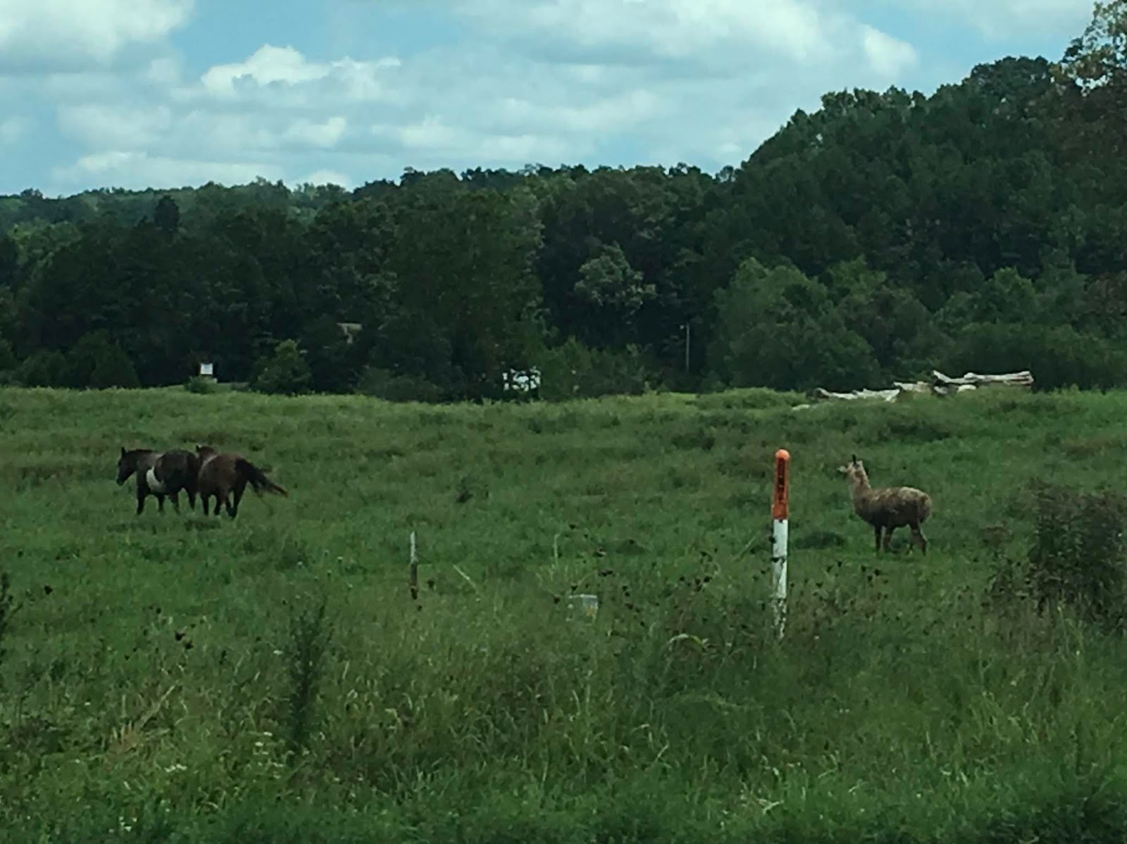
Susan stumbled across this today. I guess we can all tell who the odd man out
is in this threesome. Sucks to be a
llama in a horse’s world, I guess. Poor
llama, abandoned by horses. (Used by
permission of Susan Schoen Photography, LLC.)

This is Susan – abandoning me and driving away. I’m gonna go hang out with the llama – he’ll
understand.
Again, from Wikipedia: The Battle of Fort Davidson, also known as the Battle of Pilot Knob (note from Chuck: Civil War battles were named by the by the Confederacy based on the name of a nearby place while the Union named the battles based on a geographical place - a river or mountain.), was the opening engagement of Price's Missouri Raid during the American Civil War. This engagement occurred on September 27, 1864, just outside Pilot Knob in Iron County, Missouri. Although outnumbered by more than ten-to-one, the Union defenders managed to repulse repeated Confederate assaults on their works, and were able to slip away during the night by exploiting a gap in the Southern siege lines. The attacking Rebels took possession of the fort the next day, but Price's profligate expenditure of men and ammunition ended his goal of seizing St. Louis for the Confederacy.[citation needed]
ReplyDeleteNo word on annual reenactments.
Hey, thanks. I knew about the naming convention, but hadn’t looked up the battle details.
ReplyDelete