
Ride Report: 58 Miles, 119 Total Miles, 14.1 Avg mph, 4,154 calories, 2,907 ft climbing, 1 Wife who saved the day. (I'll not be adding to that number, BTW.) More on this later...
Today was basically Rockaway Beach Oregon to Otis, OR. But I always list the actual starting point - which was the campground. Its about 4 miles South of Rockaway Beach. I include this information here in order that the reader be better able to approximate our location. I'll try and remember to do so in the future. It was a gorgeous day today: sunny, cool when on the coastal side of the mountains, a bit warm on the back side of those same mountains, only a mild wind in my face for most of the ride - I could go on. Instead, I'll sum it up with this saying (I stole it form a plaque at a gift shop and modified it slightly) "A bad day riding is better that a good day at work." And most of my day was good. I'll detail the bad below. But on with the pics...

Shortly after setting off I was right along the shore and rounded a corner to see this. I loved the one dead tree poking out of the top of the rock on the left. Note the big smile - no "bad" yet.

Then we ran across this. I'd been hankerin for a good chance to get a shot of one of these since we were driving North on 101. I knew today might be my last chance.

Shortly thereafter we ran across this! I'd also been wanting a pic of one of these. Man - today was going well...

And then the icing on the cake was this. I hope the guys driving the logging trucks can read. Note the even bigger smile. Today was going swimmingly...

The uninitiated reader may inquire as to what this is and why I bothered with a pic. While it may be difficult to tell from the pic, its the hull of a boat - and made of concrete. I included it here because one of the posters to my site (Curtis) responded to one of my earlier blog comments about boats and mentioned that they're made of a variety of materials, to include concrete. So - here ya go Curtis, proof of your outlandish claim. I've no idea why it was washed up along the bank of what is, at best, a minor river. If Curtis answers that one in a post, I'm just gonna have him start writing the blog for me.

Interestingly, the ACA map put me on some back roads out of Tillamook. This pic was taken on one of those roads. Though its prolly impossible to tell, there is a tractor towing a hay rake in the center of the top edge of the tan stuff - which is grass that has likely been mowed for cattle feed. It was a picturesque scene. I just stopped and watched for a while.

This is the same road maybe a mile later. I might add that the ACA folks were kind enough to alert riders that there is a half mile of gravel ahead. At this point the road is very narrow and severely crowned, but this spot took my breath away. I stopped again to soak up the view. It was cool and VERY quiet. By that I mean that I could hear no sounds produced by man. The birds were making...whatever sounds birds make. I dunno I'm not a birder. But I stood there in the middle of the road for five minutes. The pines were so big they formed a complete canopy over the road. Beautiful! Now I know why the ACA guys put us on this route. Note the huge smile...
However, this is where Mr. Smiles was put to the test. I may be grinning here, but let me assure the reader that it was forced. We came out of the valley behind me. As it turns out, the route headed up severely when the road surface went to pot. Not only was it gravel, but it lasted for prolly a mile and a half, with portions pitching up at 13%. It was a steady 10%. Why? Because the area had been logged recently and the road had basically been turned into a logging road. Until, that is, I got on the actual logging road portion of the route. It had never been paved at all. At one point the pitch was steep enough that I walked for 200 yards because I knew there was no way my back tire would have enough traction to keep from slipping as I went up. On the bright side, I did have excellent cell reception up there. I used it to verify my location fearing that I had gotten lost. Nope. BTW - Google Maps called it "unpaved unnamed road", which was certainly reassuring...

Eventually we made it back to pavement. The Sequoia was so glad to see rocks held firmly in place by petroleum products that he took this pic. God bless him, I was right there with him. We had a pleasant few miles until the next hill. Which was a doozy...

I took this pic one mile up "Doozy Mountain". I've renamed it and will be informing the State of Oregon tomorrow. Whoever they named it after is prolly long dead anyway, having been the first to ride a bike up it and dying at the top. At this point it had been a mile of 4% to 6%. OK- I can hang with that. I figured it must be about over.

NOPE! I was singing a different tune THREE MILES later. The grade pitched up as the hill went on. After the first mile, there was a lot of 8.5%, 9%, 10%... Let me put it this way, the steepest grade Garmin reported to me was 13%. Good Lord! I kept looking for the top knowing that I was only about four miles from lunch at Sandlake (yes its all one word - a grocery store and a post office) with Susan. I figured that I'd probably go downhill for about the same distance I went up. Nope. Plus, I ran out of water about 1.5 miles from the top - this couldn't be good... I screamed downhill at 40+ for about 1.5 miles till I was close to the bottom. I was wiped. I saw a couple loading jet skis on the downhill and pulled into their driveway. The guy looked up at me and said, "Need some water?" They were very nice and gave me two bottles of ice cold water. Turns out I was only about a mile away from Sandlake at the time. When I met Susan for lunch my hands were shaking. I think that was the most miserable I've been on a bike in a long time. I'm not a climber. Those guys are like 135 pounds. I was 204 this morning. We'll see how that goes if this continues.

I'm sure I looked like a beat mule when I pulled in at The Rig for lunch. Susan just looked at me and started shoving food and liquid at me. She also shoved an ice cream treat at me. She ate this one, which was produced locally at the Tillamook Creamery. But she got me a much bigger ice cream sandwich. (God bless her.) I haven't had one of those in years. Hence my earlier "Wife who saved the day" comment.

She also went up the road a bit and found yet another great pullout from which the Pacific was visible. Turns out that this is our last pic of the Pacific since the route turned inland shortly after. The reader will note that one of us has as a bald pate. Hence you always see one of us in a ballcap or a helmet...

Finally comes the end of the day's ride. This is an action shot of me pulling into Otis. Used by permission: Susan Schoen Photography, LLC.
Sitting here in The Rig as I draft tonight's post, it occurred to me to look at the elevation profile of today's route. I know it sucked since I rode it, but I thought the reader might like to take a gander...

One word: OUCH. The first little spike is us getting over the logging road, the second big spike is us getting over Doozy Mountain the first hill. The final spike is the last big hill.
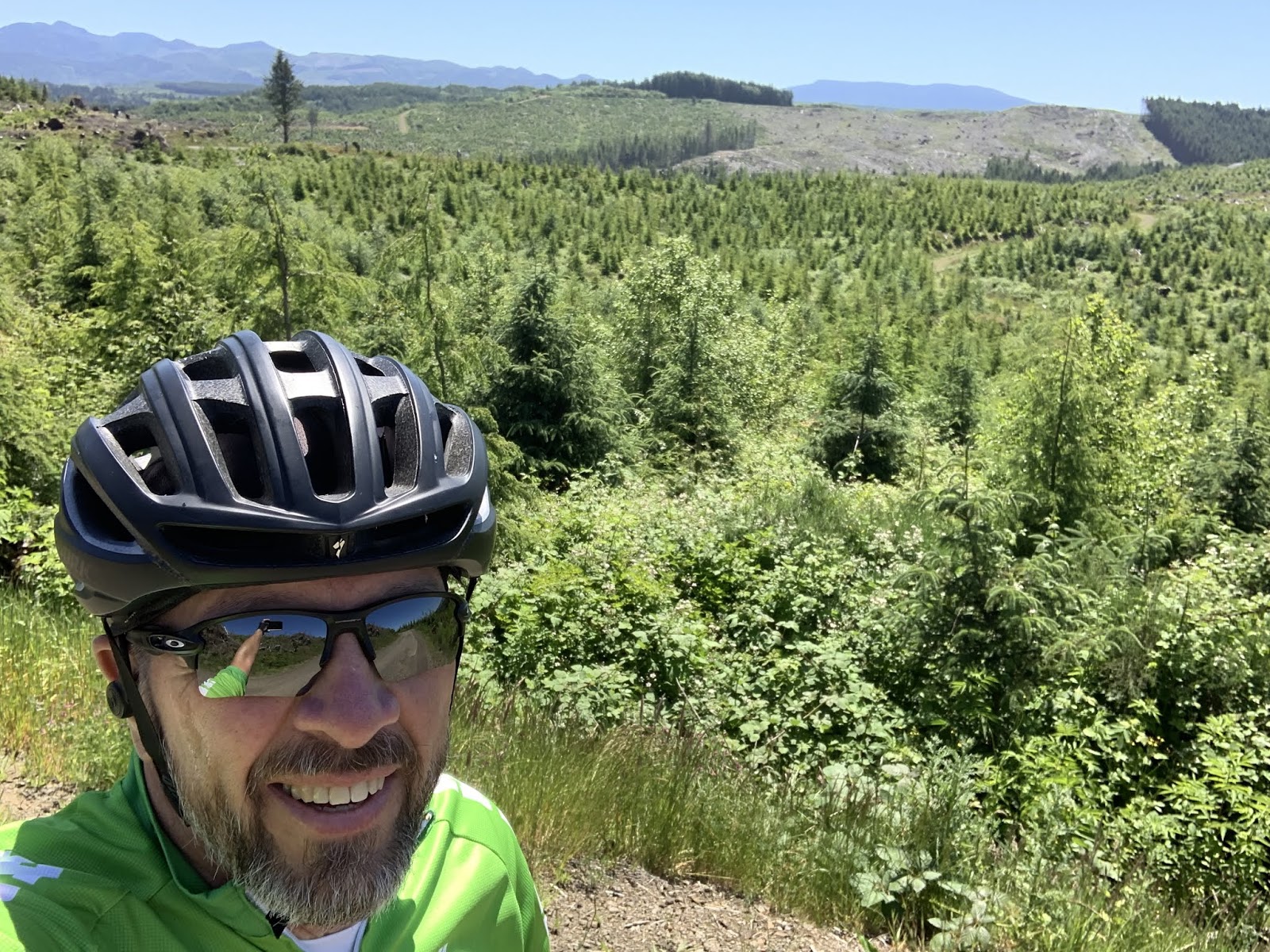
At the conclusion of the second big hill I looked like this...
The observant reader may note that this pic looks remarkably like the one I took when I topped the first big hill. There's a reason for that. I looked the same at the top of second hill. I'm just too lazy to go fetch another pic and download it to the blog. Besides, I didn't wanna waste film...
Till next time.
No comments:
Post a Comment