Ride Report: 45 Miles, 1,903 Total Miles, 14.5 Avg. mph, 2,589 Ft. Climbing, 3,427 Calories and 1 bike path too many.
We decided to go ahead and come into Frisco to stay last night. When we reserved a spot at Heaton Bay Campground, we had to take 4 nights in order to get the reservation. Since we were paying for it anyway and it was only about 29 miles to the Campground it seemed the thing to do. This, of course, meant that before the ride could start today we had to return to yesterday's stopping point at the N end of the Green Mountain Reservoir. One could either take the long way around the lake (the ACA route for the T/A) on County Road 30 or take the more direct route on Highway 9. After Susan and I discussed it, I opted for CR 30. The problem with 9 is that it is very heavily trafficked and the section by the Reservoir had minimal shoulders. Something about a lot of truck traffic and an 18 inch (at best) shoulder that just doesn't sit will when the option is light traffic. Even if the option is a mile and a half longer.
And I guess I'll just vent my spleen now before we get to today's pics. I've mentioned this before. I hate bike paths. The first half of the ride today was on roadways - just like always. But traffic being what it is, the ACA folks put us on the bike path that runs from the North end of Silverthorne where Highway 9 enters the city all the way to Breckenridge. It was the worst part of today's trip. Among the laundry list of problems: (1) Some guy throwing a tennis ball in front of me for a (loose) dog to retrieve as I rode past. (2) Three separate occurrences of people sitting on the side of the bike path and then pulling out directly toward me going in the opposite direction and doing so from the wrong side of the path. (3) Children (not their fault - parents were present) crossing the path in front of me. (4) Kids on skateboards riding on both sides of the path. (5) Tourists on bikes (not tourers) with no idea of bike etiquette. Need I go on? Bah! The next time the ACA puts me on a bike path I'll just look for the nearest divided highway. - and then drive down the center of the opposing lanes.
But enough of my incessant carping. I've not even complained about riding uphill all day and fear I may have indulged the reader in enough whining before I even get to that. So I guess I'll cancel the series I had planned on why I hate 45 mile uphill grades and just get on with the good stuff - and there was plenty today...
Susan took this pic of me as I left The Rig and headed out on County Road 30. The reader should not be deceived, the slight downhill grade seen here lasted for all of about 30 yards. I include this pic as a reference point for what comes later.
Within about three miles of today's start I went across the earthen dam that holds back water for the reservoir around which we're riding. It has a simple spillway to control the level of the reservoir. When I showed this to Susan she thought it looked like a giant water slide. I agree - except for the concrete blocks they put at the bottom where the reader can (barely) make out water turbulence just before it goes into the river channel. It was fun to watch. But shortly, I had to move along.
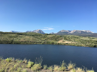
Susan took this pic when she stopped along Highway 9 on "her" side of the lake. The shoreline the reader can see is "my" side of the lake. She had a better view of the mountains than I did since I was traversing the hills and draws on my side. Used by permission of Susan Schoen Photography, LLC.
This is the view from my side about 3/4 mile after leaving the spillway. By then Delta and I had climbed to the top of a hill with a great view. If the reader looks closely at the edge of the nearest hill on the left side of the pic, one can make out the road around the base of the hill. In one spot along this road, the hill had obviously suffered a pretty significant collapse above the roadway and resulting land slide had covered the road and gone into the lake. Glad I didn't happen to be riding past then!
A little ways further down the road (and up in elevation) Delta and I came across this. This pic was taken looking back from the direction we came. Some of those cracks are 2 feet wide. Interestingly, there was a small stream on the uphill side of this mess which drained into the culvert on the left side of the pic. The culvert drained toward the bottom of the pic. After contemplating this and the earlier land slide, I concluded that in both instances, snow melt runoff had saturated the soil to the point that it lost cohesion and slumped. Not sure how ya go about fixin that. Maybe just let it stabilize and then throw some more dirt on top of it? That seems to be the approach to handling pavement seams here in Colorado - and in several other states thru which I've ridden. Just put some tar on 'em and throw on another layer of chat. Just sayin...
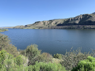
This is the view from the South end of the lake shortly before CR 30 rejoined highway 9. I liked this one because of the bluffs and the road along the edge of the reservoir. The road the reader can make out would be the same on Susan took with The Rig. It's really a pretty impressive pic if the reader cares to enlarge...
And for the paucity of good pavement early in the trip around the lake, the County got their act together for the last 4-5 miles. Delta liked this one - it shows off his "Purple Phase" as he calls it.
I didn't take much in the way of pics for a while because all there was to look at was an uphill grade. So, the next pic you see...
Is me pulling in to meet Susan at the North end of Silverthorne. Check out that pic. Mountains, trees, Delta, me. For several years before The Thin Blue Ride I thought a lot about riding the T/A, the people we would meet, the scenery. This pic puts me in the scenery. Used by permission of Susan Schoen Photography, LLC. (In the interest of full disclosure, when Susan showed me the earlier pic she had taken of me leaving for today's ride, I asked her why she was always taking pictures of my butt. This may have prompted her to get one of me inbound for a change.)
I suspect a lot of readers will know about Dillon Lake located near Silverthorne/Dillon. This pic was taken as I crossed Dillon Dam on the bike path mentioned previously. The reader with an eye for detail will note the sail boat near the top, right edge of the water. I was somewhat familiar with this path, having ridden it a couple of times when Susan and I were in Summit County for a week several years while I prepared to ride the Copper Triangle. That particular ride was 85 miles and three mountain passes. I wasn't in as good of shape then as I am now, but then again, I wasn't as old as I am now either. They prolly about balance out.
This is a great shot. The bike path wanders thru this wetland just North of I-70 and just West of Frisco. As an interesting side note, the campground we're staying at is in the green peninsula the reader can see sticking out into the lake. A great location.
Lest the reader forget, today's ultimate goal was Breckenridge. And just like magic (45 miles worth of sweaty magic, but magic none-the-less) here we are. We've already loaded Delta in The Rig and I've ditched the helmet for this pic. What the reader sees in the near mountain in the background are the ski runs at Breckenridge. We're breathing some rarefied air now at 9,600 feet. Not as rarefied as Hoosier Pass at 11,542, but still pretty rare. BTW, for the reader who doesn't care to do the math - the difference between the two is 1,942 feet. When we tackle Hoosier Pass, those 1,942 feet will be gained in 10 miles. Try it some time - just for fun...
Till next time...


No comments:
Post a Comment