Ride Report: 66 Miles, 1,794 Total Miles, 16.2 Avg mph, 3,219
Ft. Climbing, 5,199 Calories. Max speed
today was 47.1 mph. Which, by the way,
was a hoot. I don’t think this is a new
record for the trip as I believe there was one mountain in Oregon where I hit
47.2. I will check and verify to sate
the reader’s prurient interest.
OK - I'm back. Sorry for the 24 hour delay. When I typed that up we didn't have service. But I checked today and the actual high speed was 47.5. So - I was in error. don't tell your children.
OK - I'm back. Sorry for the 24 hour delay. When I typed that up we didn't have service. But I checked today and the actual high speed was 47.5. So - I was in error. don't tell your children.
As we’re getting closer to Breckenridge, both Susan and I
are eager to get there as early as possible on the Wednesday the 17th. This for a couple of reasons. First, we get to see Kelsy and Parker
(KnP). Second, both the bikes need some
work and I’ve arranged with a shop there (on the one day when we did have cell
service recently) to take the boys in for tune ups. The net result of this desire on our part
will be to stretch the remaining riding days (as I did yesterday) in order to
shorten the trip from Kremmling to Breckenridge, thus arriving earlier in the
day. We do that by riding past our
destination, setting up for the night where we can, and starting early the next
morning to have more ride time.
This plan ran afoul of Mother Nature today when we had about
10 miles to go to reach Rand. A
thunderstorm intervened. As it happened,
Susan and I had arranged to meet half way between Walden and Rand. When the rain hit, I had about two or three
miles of wet riding before reaching The Rig.
Once I went in, I didn’t come out for an hour and a half. We’re in the mountains – it would rain, stop,
the roads would start to dry out, repeat – about four times. When the roads finally dried out for the last
time, I took off and ten miles later was in Rand. We talked briefly there and agreed to ride about
half way up the pass to the Continental Divide before calling it a day. And that’s where we sit now – on a United
States Forest Service (USFS) road about a hundred yards off Colorado 125, which
is the road over the pass.
Thankfully, the view changed late today, though the terrain
in which we were riding didn’t. What
this means is that the real mountains came into view again. This is good because it means that I get to
look at something other than sage brush covered hills. This is bad because we’re intentionally
heading toward these mountains in order to go over them. But this is the way of things on the
T/A. One of the tourers I met today
responded with this when I asked how bad the pass to the Continental Divide
was, “It’s a mountain. It wasn’t as bad
as some of the others.” That pretty much
sums it up. On with today’s pics…
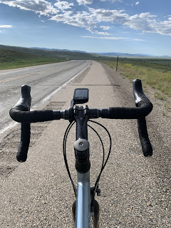
Yesterday’s stopping point meant that the first thing on the
agenda was a four mile climb ranging between 4-7%. Not my favorite way to start the day. Frankly, I’d rather eat oatmeal for
breakfast. But as you can tell by the
pic what with the road running out in the valley below the crest of the hill,
it’s gonna be a fun descent.
The sign didn’t lie – it was 7%. The bonus was that it was relatively
straight. This meant that I could get down on the bike to avoid as much air resistance as possible and let gravity do
its thing. The result was the previously
mentioned top speed of 47.1 mph. The
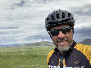
observant reader may notice something different about me in this pic. The safety conscious reader will wonder where
my helmet is. I think the answer to this
last question is obvious. It’s in The
Rig. I forgot to put it on. Susan forgot to notice. What with no cell
service, I couldn’t call her and she was long gone by the time I noticed. But
her failure to notice only lasted until I met her at the Colorado line at mile
17 of today’s ride.
This was my reaction to my own stupidity. I couldn’t believe I’d forgotten my
helmet. I included this pic for the
clueless reader.
Sig wanted this one included. He couldn’t wait to get going.
I’d been seeing these for some time now and wanted to wait
for a great pic before posting. I think
this pic is great. The entrance made out
of pine logs, the white gate, the buildings centered in the gate, the hills in
the background. Just great. BTW – they don’t ponder creek names much in
these parts. It was a creek. It was big.
It’s a ranch. Its near Big Creek.
And related to ranching... I went past one pasture today that was filled with black Angus. Not unusual along this section of the T/A. But as I got closer, I noticed that they were all bulls. Now I'm a ways removed from my farm days, but I recognize a bull when I see one. There must have been 150 of 'em. What on earth does a rancher need that many bulls for? Yes, yes, yes - I know. I took particular note of that part of biology class. What I'm getting at is the size of the ranches in these parts. I mean, how many cows can one bull "service"? Whatever that number is, multiply it by 150 and you'll know how many cows that particular ranch has. Wow!
And just 17 miles into the ride we arrived at the Colorado
border. Time for the obligatory
pic. I have several of these from riding
BAKs over the years. Some even have
sagebrush in the background. So far as
I’m able to determine, they’re interchangeable.
The reader may be wondering how many states we’ve ridden thru. The answer…
…is FIVE. It dawned
on me today that when we hit Kansas, I won’t know what to do. I hold the camera with one hand and have only
five fingers on the other hand. Kansas
will be state 6. And what of all the
states that follow? I recruited Susan to help out today. This is just an audition. She seemed to handle the responsibility well,
but can’t commit without checking her Teamster’s contract regarding secondary
employment. If that turns out to be a problem,
I’ll just have to take off a shoe and work with what God gave me when we hit
Kansas.
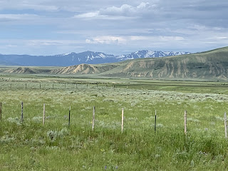
OK – the ones in the distance are the real deal – and
they’re starting to make themselves known.
We’re headed straight at ‘em. No
fear left in any of us any more when it comes to mountains.
A close up of the same bunch of characters.
Oh yes – we stopped in Cowdrey (aptly named) for lunch. A lunch made more difficult by virtue of what
the reader sees all over the ground in this pic. That, my dear readers, is none other than cow
poop. That’s right – cow pies strung
about the main drag thru town as if, well…a bunch of cows had just “passed”
thru. My brother in law, Chris, says
that’s the smell of money. I dunno – all
I know for certain is that I had to look twice at my sandwich before taking a
bite. Susan says I should have paid an
equal amount of attention to where I stepped on the way into The Rig. The highway outside town was in the same
condition – and for a good distance. For
my part, I was just glad it wasn’t a rainy day…
This is Theo. He’s
from Boston and has a limited amount of time left to finish his ride this
summer. Though we met on the T/A, he’s
not been on it for his entire trip. He
aims to get to Glacier National Park and points West before he has to call it a
ride and return to real life. As always,
we had a nice chat (in which I warned him about the construction on I-80) and
headed our separate ways.
When I saw this scene I just had to stop and take a pic for
Susan. I hope the reader appreciates it
as well, but you all weren’t my target audience with this one. Check out those yellow and purple flowers in
the foreground.
They’re getting closer…closer… Somewhere in there with the big boys is Willow
Creek Pass. There are really only two
major passes left in the Western half of the T/A. Willow Creek is one and Hoosier Pass is the
other. They will require three more
riding days. But lest the reader forget,
once we make it to Breckenridge, we’re taking two Rest Days before tackling
Hoosier Pass.
Stay tuned.
Till next time.
Till next time.


No comments:
Post a Comment