Ride Report: 55 Miles, 3,562 Total Miles, 13.4 Avg. mph, 4,452 Ft. Climbing, 4,437 Calories.
Compared to yesterday, just about the same amount of climbing but check out the average speed. Significantly lower than yesterday over a shorter distance. The answer to this mystery is that the same amount of climbing was packed into less miles. Meaning a higher percentage of my time was spent climbing than yesterday with no off-setting time on “flat” roads with which to pull the average back up. And the biggest climb of the day came at the end, it was probably 4-5 miles long and ran mostly 10-12% - though I did see some 13%. Good Lord. I’ve included Garmin’s elevation chart for the day immediately below, just to give the reader an idea.
To really understand this ya probably need to enlarge it. The gradations on the left side are 200 ft. It was the climb up to the three headed monster to the right side that was at the end of the ride and ran 10-12%. I bled off average mph at a serious rate going up that thing.
Let’s see, what else happened today. Oh yeah, I was chased by dogs 5 times today.
There were the two who got in the road ahead of me and made perfectly clear their intent. I dismounted and began my standard “NO” conversation with them. They weren’t buying. The owner heard the commotion, opened the door of his trailer, worked his round form out the rectangular door, looked at what was going on and went back inside. Well, that was helpful. Although I tried my handy dandy dog repellent it only worked moderately well, since they still tried to chase me as I left. But this brings up an ancillary thought. Why use dog repellent on dogs that, of their own volition, are already quite repellent? Just a thought.
There were the two Australian Shepherds just over the crest of a hill who tried to sneak behind a bush from which to ambush me. They were eventually out in the road and were so aggressive that I had to walk past with the dog spray in hand.
Then there were the two terrier mix yappers who managed to pull off an ambush. Fortunately I saw ‘em coming from just behind my feet as I went past. When one of them lunged at my left foot, I raised my left pedal. To my great satisfaction, he missed my foot and collided with my rear wheel - which was moving at 20 mph along with me and the rest of the bike. I felt the thump, heard the yelp and can only hope that he stuck his snout in the spokes and got a seriously bloody nose. And that's the kindest thought I have about him.
I won't even bother to recount the rest. Dog owners in Kentucky are just plain irresponsible. But I have developed a sense of where these things tend to happen. I look for disheveled properties (mostly trailers) packed fairly close together, right along the narrow and little used roads. Throw in several old cars which are clearly not running and other assorted junk, and ya have prime dog chasing territory. Complain and think less of me or believe that I'm stereotyping if you will, but those are the common denominators. My main goal is just to make it out of Kentucky without extra holes in my leg.
Now - on with the day.
This is me standing at the top of the first downhill of the day. Which just happens to be from the school parking lot where we stayed last night down to the highway where I turn left to head to Chavies, KY. And as far as I can recall it's the ONLY 11% DOWNHILL I've ridden on the entire trip. But then, I'm a bit too busy to check out Garmin going down these hills. Hey - It's early, it's cloudy and cool, and I wasn't chased by any dogs in the first 50 yards getting here - so far the day is all rainbows and unicorns.
See all that squiggly stuff just to the left of Chavies? Now go back and look at the elevation chart and find the three headed monster at the end. Yup. I had a clue going in.
The first climb of the day up out of McKee, that's why I'm still smiling. It only ran 6-7% for maybe two miles.
I should insert here that upon learning of my former life in Law Enforcement, the ACA asked me to see if I could learn anything about the three riders who disappeared in Kentucky several years ago under mysterious circumstances. One of the tidbits of information I had was their bike descriptions. I sent them my report today...
I found their bikes and concluded that they were eaten by Kentucky dogs. Further, that the dog's owners put the missing rider's bikes on display as trophies. I didn't dawdle here as I didn't want my bike added to the line.
Then I came around a corner and saw this. It was just too good to pass up. And since I know some of my readers are mostly into picture books, this is for them. You know who you are...
And these would be wild turkeys. While there are only six in the road, there were probably 15 or so total. These are all poults, but I saw two adult hens with this crew. I was a bit surprised they still had so many poults as predation usually reduces their numbers significantly by this time of year.
As we work our way further into the Eastern Kentucky hills, scenes like this are becoming more common. Agriculture is pretty much confined to these narrow valleys, as are the highways - unless of course the highways need to go over a ridge line to get to another town. They seem to mow a lot with what I call brush hogs here. I'm not sure what the purpose is, other than maybe keeping the growth under control?
This, readers, would be Boonville, KY. Yes - that Boone. Susan looked at the pic and said I should edit it to straighten it since all the buildings appear to be leaning to the left. I explained that there was nothing wrong with the pic. It's the town that leans left. All these Kentucky towns in the hills do that. They're built on hills for God's sake. It being easier to live with a pic of a leaning town than returning to straighten everything up, she was satisfied with the status quo.
Not one of the bigger hills of the day, but ya can always tell when they go from 6% to 9%, eh?
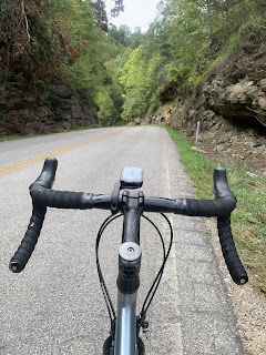
It looks like this a lot around here since they have no choice but to cut roads into the side of the hills. If nothing else, it gives the highways some visual appeal.
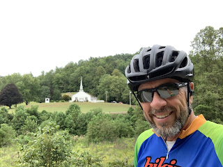
This was a great scene. It being Sunday morning today, everyone was just pulling into the church parking lot when I got there. I was struck by the scene and stood to look at it for a while. I've noticed that there are a lot of churches seemingly in the middle of nowhere out here. But then, the towns spread up and down the valleys since that's where the buildable space is. Additionally, this church has been here for a long time according to the historical marker at the entrance. It's just as likely that when it was built, there were a lot of small farms in the area, I guess.
This sign was especially...puzzling...since we are in hill country and there was no cell service here. Maybe they mean to say that one should call when one reaches the top of the hill? I can't breathe then, let alone talk.
This would be the top of said hill - the first of the three headed monster on the elevation chart. Note how rapidly the road disappears from the reader's view.
This is me nearing the top of the next hill of the three headed monster. Readers who look closely will see a rider wearing yellow coming down the hill just to the right of the bend in the guard rail. No, that's not a road sign. The look on my face was due to the slope in front of me. But when the rider whizzed past, I was equally as surprised. That guy was moving - and he was skinny! I must move faster than him on downhills - that's all I'm saying. The reader can figure out the rest.
I gotta tell ya, this was a tough day. Thankfully it was cloudy and cool all day. I don't know that I'd have made the entire 55 miles if the heat index was 104 like it was last week.
Stupid dogs.
Till next time.


No comments:
Post a Comment