INTRODUCTION

Where to begin? It was a dark and stormy night...  (Snoopy).  No. It was the best of times, it was the worst of times...  ...

Tuesday, June 4, 2019

The Thin Blue Ride - Part 1 - Day 13

Elk Grove, CA to Indian Creek RV Park N of Redding, CA:  212 miles (RV)

Ride Report:  27.6 miles,  97.0 total miles,  17.3 mph avg, 1,950 calories, 170 ft. climbing.  The reader may note that this route was especially flat.  Given that, the reader might rightfully inquire as to the reason for my relatively low average speed.  The reason for this anomaly will become apparent later in this post.

The day started off well and ended the same way.  First up was a ride.  It had been a few days since Delta got to spin his cranks, so he was ready and rarin' to go.  So let's get to it...


We left Les and Irene's place and within just a couple of miles ran across this odd dandelion.  It piqued our curiosity.


Until we saw two shorter, bushier versions.  Clearly something was afoot...


But we are nothing if not easily distracted and this sighting of the Sacramento River quickly removed all thoughts of giant dandelions from our minds.  Interestingly, the river was apparently widened for commerce, largely by virtue of the efforts of man and beast when doing so was the way of things.  However, we understand that it has since been supplanted by a larger waterway a few miles to the West.  So - not much boat/barge traffic here nowadays.


AH-HA!  So this is how they spread.  By infecting the brains of intrepid cyclists and thus being transported to locations previously not afflicted by this blight.  Now that the cycling public is aware we should take steps to stop the spread.  Unless of course, we want sunny skies and temperate conditions to overtake the country.  I think not.  I shall be doing my part from today forward.
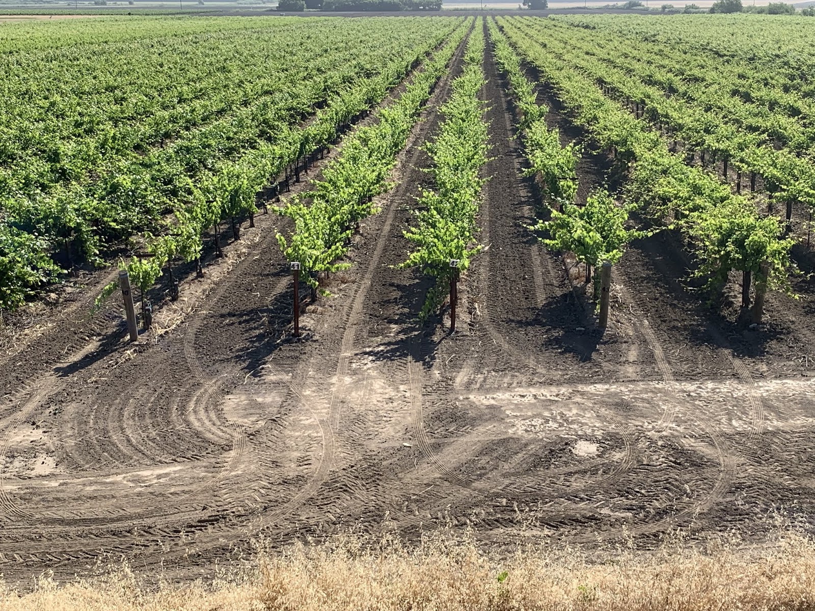

More grapes.  What are they - groves, fields of, gaggles?  I'm clueless, but there are miles and miles of them hereabouts.


These, good reader, are pears.  I hear from a local that the shrubbery around the field has the purpose of reducing wind amongst the pear trees.  So, if this is wrong - blame Irene.  Just sayin...


Note that there are no pear trees sprouting from my noggin.  Thus proving that only tall, awkward dandelions are spread thusly.


Delta just couldn't pass up this river shot.  The road we're on is on top of the levee.  Very flat.


The bridge at the turnaround point.  There is another about 10 miles south of where we joined the levee road, but to cross and go that far South adds another 10 miles to the ride - and we need to get back to we can get The Rig rollin down the road toward today's destination.


These two are Rudy and Caroline.  Rudy being the bearded one in front.  As I was headed North on the levee road and about to arrive at the previously mentioned bridge, they passed me headed South.  After I turned around to go back South I eventually caught up with them.  This necessitated a slowing of the pace to chat them up.  Turns out that Rudy is Dutch and Caroline is from the Philippines.  They had previously lived in San Francisco, but moved to this area in order to get away from the high prices.  According to them, everyone is trying to leave.  That should prove interesting.  Who, for example, would paint the bridge?  I see disaster in the offing...  


Les and Irene's place and our place.  Ours is the one on the right.


Brad, Irene, Susan and Les.  Good Lord, I feel like Gandolf...
OK - Susan is gonna insist that I report that she squatted for the pic in order not to obstruct the reader's view of Irene.  That's her story and she's sticking to it.  Take it up with her if you must.


This is the same Sacramento River along which I rode this morning - albeit further North.  This pic was taken, interestingly enough, just West of Sacramento.

Rice paddies.  Never seen these before, but there were a bunch as we worked our way North in the Central Valley.


It was interesting to watch the mountains grow closer to I-5 on both sides as we worked North.  By the time we got to Redding it was apparent that we were gonna have to go thru them (not that we were previously unaware) to get to where we wanted to be.  I think the snow capped one is Mount Shasta - elevation 14,179.  Pretty impressive given that we're still about 70 miles away.  But at that elevation, I guess it makes sense.  Its roughly the same height as Pikes Peak in Colorado, which we can see from our daughter's back deck in Palmer Lake, CO.

And sure enough - we know the drill...


And finally, a couple of shots of a lake up in the mountains after passing thru Redding, CA.


Unfortunately it looks like a wildfire blew thru the area not too long ago.  When we checked in to the RV part, Steve (who manages the place) told us that there had been a couple of different fires in the area last August.  They even had to evacuate.  The best known of these fires was the Camp fire, named after Camp Road where it started.  According to Steve, the Camp fire burned over 100k acres and caused significant damage, though that's not the burned out area in our pics.  Regardless - terrible.


And finally readers, our home for the night.

Till next time.

The Thin Blue Ride - Part 1 - Day 12

Yosemite, CA to Elk Grove, CA: 151 Miles (RV)

Ride Report: None - which is unfortunate,  I had wanted to ride the road beside the river which would have been handy since it runs right past the RV Park.   But yesterday afternoon's rain put the kibosh on that.  But that's life.  So, on with today's report...

When we left the Park, we headed West on 140.  Its worth mentioning that the State (or the Park?  Who knows.) is working on 140 and as a result had to close down the road on "our" side of the river.  This, of course, necessitated moving all traffic to the other side.  To do so, they installed two temporary bridges...

Ingenious.  And also the reason that traffic on 140 into the park was restricted to vehicles under 45 feet.  A wise move regardless, if you ask me.


While Susan was driving on the way to Elk Grove, I decided to pull up Google Maps for kicks just to see where we were.  This screen shot gives the reader the same view I got at the time.  It made me giddy.  Why?  Because - I'm NOT AT WORK!  I know I've said that once before and and henceforth will try and restrain myself in deference to those still slaving away for the man.


Oh yes - and then there was this.  We stopped for lunch at a truck stop (Susan never tires of their food) and she decided to work the line on the teamsters side of the fueling stations there.  I think she was wanting to check and see if any of her buddies happened to be there.  I knew nothing good would come of this...


And sure enough, a few minutes later she came back all a twitter over one of her buddy's rigs.  This is it in the background.  The literate reader will note the name of the rig on the side of the sleeper.  That's right, the "Hillbilly Mansion".  She told me she had talked to Bubba who had agreed to trade for our Rig straight up.  While it is a good looking "mansion", I refused.  She's just gonna have to get it the old fashioned Teamster way - win it in a poker game.

After that it was back in The Rig and on the road again.  We reached Elk Grove (and the house of Susan's brother Les and his wife Irene) in good order and are invited to spend the night there.  This is good news because we get to visit them and because they have a REAL shower.

We had enough time to run an errand to (where else) Wally World for some necessities and then Les and Irene took Susan and I on a brief tour to the countryside near their house.  I viewed it as a scouting mission for (hopefully) a ride before we hit the road tomorrow morning.  Time will tell...  I'll post some pics tomorrow.

And finally, Irene has been threatening to send Susan a pic she says I have to use in the blog.  Its apparently from Wally World.  It's not here as I complete this blog, but Susan says I have to give Irene time to send it before posting the blog.  Irene???  (Added later) Apparently, to my good fortune, she has forgotten to do so.  Dodged a bullet there.

OK then - I think that's more than enough for today.  Hillbilly Mansion - Good Lord.

Till next time...

Monday, June 3, 2019

The Thin Blue Ride - Part 1 - Day 11


Yosemite – Day 3

Yosemite, CA: 0 Miles (RV)

Ride Report: None

Today’s report begins with a 1.5 hour scoot over to the Mariposa Grove of Giant Sequoias.  It was a beautiful day.  On the drive over we felt like we had the road to ourselves.  Prolly because everyone was coming to the Valley here in Yosemite, while we were in the Valley and headed WAY down South, near the exit.  Kinda like driving out of (insert big city here - take your pick) in the morning.  Everyone else wants in.  It was great.  Susan was mildly unnerved on that section of 41 where the edge of the highway was near the edge of the mountain.  As I write this, its raining outside, but when we arrived at the Mariposa Grove everything was bright and sunny…

OK - Susan has always wanted to see these, and I'm right there with her.

And it didn’t take long to run into a Giant Sequoia.

This is a small one.  The reader should take note of my photographic talent what with the sun "halo" surrounding the top of the tree.  That was by design.

Next thing we ran into was this…

If that last one was a baby, this one is like visiting the cemetery.  Apparently its been around since before the first European settlers arrived and may take several more centuries to decay.  Gotta love me some Park guys – they give ya all the details.


This is the root ball of the previously pictured dead Sequoia.  Apparently even the dead ones are named.  This is “Fallen Monarch”.  The Park guys/gals also claim it was in this condition when the first Europeans to the area saw it.

OK – this one is a teenager.  Apparently one can use the "pano” feature on an iphone while holding the phone in landscape position.  Pretty cool.

Next up on the hit parade were these...

Note the sign in the lower center of the pic - "Bachelor and Three Graces”.  He sounds like a skirt chaser to me.  I plan to call some of my feminist friends and have them get after the Park guys...

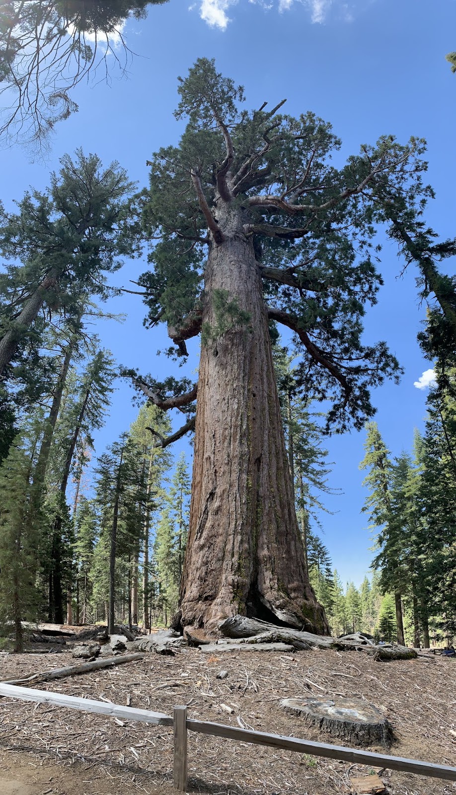
This next one is one famous tree.  Not being a Giant Sequoia guy before arriving I learned that this one, known as “Grizzly Giant” and was here when TR (that would be Theodore Roosevelt for those of you who slept thru history class) showed up with John Muir.  Mr. Muir was a naturalist and motivated TR to protect the Mariposa Grove by federal edict.  Hence, its part of Yosemite.  That big branch you see sticking out at 90 degrees on the right side of the tree is 7 feet across where it connect to the main trunk.  WOW!

Hey – if you’re a famous enough tree to have a name, you deserve a solo shot.  This, by the way, is the Giant Sequoia version of your Great Grand-pa: wrinkly, broken down, needs a cane, you get the idea.


This is the “California Tunnel Tree”.  Good thing the Park guys thought to include the state where the tree is located in the name.  At first I confused it with the one in Kansas and thought they stole ours.  Those Park guys think of everything.  The reader is obliged to forgive the cheesy tourist nature of the pic.  I mean really – why put a tunnel in it if we aren’t supposed to do the tourist thing?

The observant reader will have noticed that to this point, there has been no pics of either Susan or I in contact with an actual Giant Sequoia – well, absent the tunnel tree thing.  We saw several small signs 
at the base of the Sequoia’s saying that the site was “under repair” and thus “closed”.  We saw other signs saying that the multitude of tourist feet around the base of these giant trees could harm the tree leading to their eventual demise.  Apparently, Ponderosa Pines aren’t similarly affected since we could run circles around one if we wanted and no one would care.  However, the Park guys deigned to permit mere mortals to approach this tree and actually stand near it…


Yes – that’s an actual Giant Sequoia behind us.


As a side bar - I've been to California a number of times before this trip.  But all were enforced trips, meaning that they were work related and I didn't necessarily come voluntarily.  This trip was purely by choice.  Having now been in the state for a number of days, I think it obvious that I've been here too long.

C’mon now, use your imagination…


If the baby and the great grand-pa pics came earlier, this one is the middle aged Mom.

We spent several hours with the Giant Sequoias and I must say that it was time well spent.  I'd encourage anyone who has a chance to make the trip.  But while I could have stayed longer, I had the feeling that the Park guys/gals stirred the Sequoias up against me.  I can imagine no other reason that they would begin grumbling for me to depart.  But depart I did.  I suspect one of the Park guys/gals has taken umbrage at my mention of them in this blog.


Us, saying good-bye to grand-pa on the way out.


Bah - it was time to go anyway.  The scooter was feeling neglected by this time.  So much that so that upon arriving at Tunnel View overlooking the Yosemite Valley, he insisted on this selfie.

Not bad, but clearly not up to my standards.  See pic below...


HOLY COW!  Can you believe I took this with a phone!!!  WOW!  After taking the pic we headed down this narrow valley to the valley floor.  BTW – “Bridalveil”.  And don’t get after me about the spelling.  That’s how the Park Guys have it on the map.


Another waterfall... I believe this one is called “Ribbon Fall”.  How original.


This is us with Bridalveil in the background.  I thought Susan's smile was killer in this one.  The only reason I put it in the blog is because we look like a couple of geeks with the helmets on and it might embarrass the kids.

Till next time…


The Thin Blue Ride - Part 1 - Day 10


Yosemite – Day 2

Yosemite, CA: 0 Miles (RV)

So – here’s the cliff notes version of a day at Yosemite National Park:  Drive into the valley, park scooter, look @ map and get on shuttle bus, get off bus, hike up-hill to amazing view of mountain/waterfall, hike down-hill to shuttle bus.  Repeat as desired.  Take shuttle back to gift shop, buy cool ball-cap, walk to scooter, return to RV – tired and with sore feet, but happy.

For those of who want the view from 30,000 feet, there ya go.  You can go back to checking your e-mail and text messages.  For those of you interested in a bit more detail, check out the rest of the blog below.  The reader should be advised that this post may have more than the normal number of pics as the day was…

AMAZING!

Here we go…


The Muir Trail on the way up to Vernal Falls.  Bah - this is a cake walk.  Dunno what they mean when they describe this hike as "Strenuous".  The smile means we don't know what's coming.


We thought this was just a good photo-op.  A very nice lady agreed to take this one for us.


Hmmm....  The grade is pitching up, but I'm still smiling!


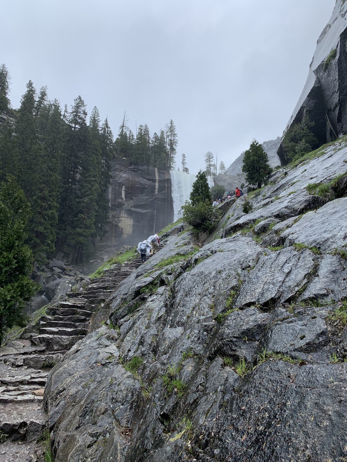
OK - now things are getting serious, but at least the Park guys were kind enough to make steps for us.  Still easy peasy...  "The Mist Trail"


Susan was so eager to get there that she was racing ahead.  Typical...  Still on "The Mist Trail".


OK - this is serious.  The last person in line is my lovely bride - who is afraid of edges.  How she pulled this off I've no idea.  Gumption?  It had to be hard for her, but there she goes.  She later described the rail as "wobbly". Still on "The Mist Trail."


When they said we'd get wet on "The Mist Trail" they weren't kidding.  Those Park guys/gals know what they're talking about, by gosh - at least occasionally.  I suggest they re-name it "The Downpour Trail" and will be recommending same to the Park guys/gals. Check out the jacket and the beard.  This is all mist blowing back from the waterfall.  Thank God for Gore-Tex.  Readers who look closely will note flecks under the brim of my hat and in front of my face.  If it were falling down instead of moving up/sideways, I'd call it mist.


Still on "The Mist Trail" below Vernal Falls.


We finally made it.  Time for lunch!  And a great spot for it too.


After lunch it was up, up, up.  The Park guys/gals discourage anyone going back down "The Mist Trail" for fear of people slipping and falling on the wet granite.  The long and short of this "suggestion" is a slightly longer, but much drier trip back to the trail head.  We're both already dry.


Still above Vernal Falls.  This is Nevada Falls in the background.  Same river creates both.  The trail continued on up to Nevada.  Susan was game, but my left foot was killin me.  Fortunately I married a sympathetic woman.

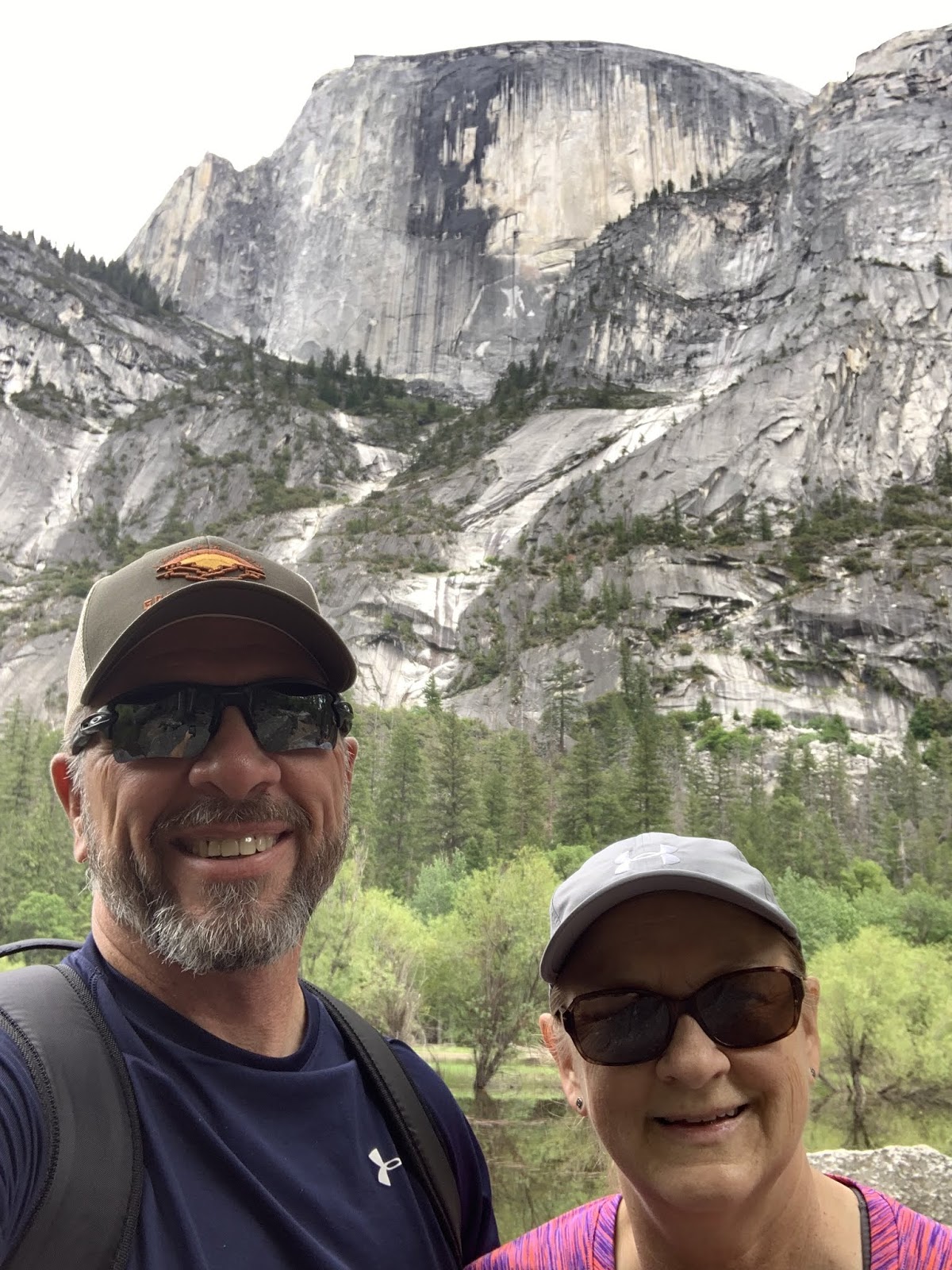
After visiting the falls it was off to Mirror Lake.  A misnomer as the Park hydrologists (who get paid to know these things) have decided that its really not a lake.  Its just a shallow pool of water created by a granite slide blocking the creek long ago.   Sounds kinda like a lake to me, but far be it from me to argue with a Park hydrologist.  I've heard those guys are an opinionated lot who don't take kindly to non-hydrologists mucking up their stuff.  Anyway - it looked like this...

That's the Mirror (non) Lake in the background with us getting in the way of the view.


OK - we're still in the way, but this time you can see why they call it Mirror (non) Lake.

I told ya, mostly pics this time.

Till next time...

The Thin Blue Ride - Part 1 - Day 9

Bakersfield, CA to Yosemite, CA: 201 Miles (RV)

Ride Report: None

I know that there are those among you pining away for your daily dose of happenings in my life.  Just know this, I tossed and turned at nights worrying about all 9 of you.  Seriously.  (Nose grows)

Most of the trip up to Yosemite was spent transiting California’s Central Valley.  Its largely an agricultural area dominated (at least along highways 41, 99 and 49 where we traveled) by vineyards, almond and pistachio groves, oranges, and not insignificantly the raisin capital of the world.  For the uninitiated, that would be Selma, CA.  I’d put money on an annual raisin-fest with a parade, speeches by local politicians in honor of the raisin, raisin pie, and a raisin queen – complete with wrinkles.  Rumor has it that to be elected one must be over 85 and able to raise one’s arm above the height of one’s ear and wave obligingly to an admiring public.  The competition must be fierce, among those still alive.  But on to other weightier matters.

Oh yes – and we now all know where those “Halo” oranges come from.

They come from right here in river city.  It was a new experience for us to pull in to get gas at truck stop and see an entire semi load of oranges go by.  In Kansas semis haul wheat and cows.  BTW - this is not a road sign.  Its a huge (processing?) building.


We passed field after field of these.  We eventually determined that they are nut bearing trees.  Almonds, pistachios, etc.  All in very orderly fields with nary a weed to be seen.

We also noted that the State of California pays an inordinate amount of attention to highway medians.  These things were everywhere on the route today – at least until we closed in on Yosemite…

Gotta admit, this is impressive.  And these are just the pink ones.  In several places they were mixed colors: white, yellow, red.  Pretty cool.


And then there was this pic.  Just too good to leave out.  Used by permission: Susan Schoen photography, LLC.

If only the State would pay as much attention to the paved stuff.  Though in California’s defense they do have a LOT of traffic and even MORE truck traffic.  All that traffic has to wreak havoc on the roads.  But curiously, I’ve begun to note that even in areas where the highway has been recently “remodeled” they never do the portion under a bridge.  This is curious as these areas, at least in my experience, have accounted for some of the worst sections of pavement we’ve seen.  I personally blame one such section for the trailer tire failure we had yesterday, but if you're Susan's pessimistic brother Jim you'll say, "I told ya so.".

Anyway, the trip up was largely unremarkable until we started climbing toward Yosemite.  For some reason Google Maps put us on a couple of sections of what had to have been (at best) minor state highways and (at worst) a very short section of County Road – if that’s what they call em here.  Poor Susan. We had arranged for her to drive the last section up to Indian Flats RV Park located just 8 miles outside the gates to Yosemite.  This in order that she get some experience with steep grades.  She got that in spades.  My phone has been ringing off the hook ever since.  All New Jersey numbers.  Thus far I’ve not answered.  My guess is that this got bumped all the way up to the Teamsters National Organization, and I doubt that they’re calling to wish me a happy retirement.  Check out some pics of the action that put me on the Teamsters hit list…

A relatively benign up-hill section.  But these up-hill sections went on and on.


Thus, we eventually encountered this..


And this...


And this.  Holy Cow - she hit the trifecta...

Despite the signs, it didn't look too bad.  At first...


But on second look, there was this.  Susan immediately noted the dirt bank on the outside of the curve and was calculating how best to use it to her advantage.  I dunno, maybe this goes back to her dirt track days.  I politely insisted that she just slow down and stay on the pavement - if one considers a blood curdling scream polite insistence.  OK - maybe I exaggerate, but I was nervous.  Side bar: note the olive green trees in the valley below.


These are the same trees as we careened (sorry - "went" ) around the corner.  Those babies are prolly 100 feet tall.  And I'm looking down on em.

But Susan handled it well.  At this point I anticipate her taking on “drivers in waiting” in order to train the next generation of our nations truck drivers.  So, when some guy named Guido shows up in South Dakota and rides along for a week with us, the reader will know what’s going on.  If my posts stop shortly after Guido shows up, the reader will know to call the police and report me missing.

On the way in to the RV Park we stopped to admire the Merced River, which is flowing quite vigorously right now.  No doubt due to this years snow pack.

They don't make em like this in Kansas.  Well - OK - Us they do, but not the river.

Before dark we went on a walkabout of the RV Park and its environs.  It was a notable trek and there was a very nice park along the river's edge just across the street from the RV park.  I encountered a couple of bears and Susan managed to snap a pic of me with them.  See below…

Wild river bear.  A rare sighting.


C'mon! How many other guys do you know who have kissed #angelbear?


Then there was this guy with the camera.  Next thing I knew he was making a pass at me.  But I was having none of it…

I told him I was an old fashioned guy from Kansas and to keep his paws off me.

In reference to these last three pics - The new reader is advised to check some of my old posts.  I believe that in the first 2-3 posts I lay the basis of my penchant for kissing statues.  Hey – gimme a break.  I can quit any time I want.  I just don’t want to.  It doesn’t help that Susan is an enabler…  
One of us is clearly dysfunctional.

Tomorrow is our first day in Yosemite.  We’ve already got the Scooter unleashed and will be ready to take off first thing in the morning.

Till next time…


The Thin Blue Ride - Part 1 - Supplemnent Report 2

OK - my apologies again.  Turns out that the proscription against cell and wi-if has spread beyond The Grand Canyon.  It’s like a virus.  The long and short of it is that when we made it to Yosemite - no service.  We thought about paying $9.99 for 12 hours from the hotel next to our RV park, but when we went to sign up their disclaimer was that it might not work.  Let me get this right, we pay $9.99 and it might not work? Pass.  So - Being back in civilization again, the posts shall re-commence.

Here’s a taste of what’s to come...

Susan doing her impression of Samson - a biblical reference - read the story.  They used to be straight.

Till next time...